


Summary
This is a list of the National Register of Historic Places listings in Marion County, Texas.

This is intended to be a complete list of properties and districts listed on the National Register of Historic Places in Marion County, Texas. There are one district and 17 individual properties listed on the National Register in the county. Sixteen individually listed properties are Recorded Texas Historic Landmarks while the district contains many more including one that is a State Antiquities Landmark.
This National Park Service list is complete through NPS recent listings posted April 12, 2024.[1]
Current listings edit
The locations of National Register properties and districts may be seen in a mapping service provided.[2]
| [3] | Name on the Register[4] | Image | Date listed[5] | Location | City or town | Description |
|---|---|---|---|---|---|---|
| 1 | Alley-Carlson House | 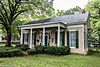 |
October 28, 1969 (#69000206) |
501 Walker St. 32°45′34″N 94°21′00″W / 32.759444°N 94.35°W | Jefferson | Recorded Texas Historic Landmark; part of Jefferson Historic District |
| 2 | Birge-Beard House | 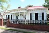 |
August 25, 1970 (#70000754) |
212 N. Vale St. 32°45′27″N 94°20′46″W / 32.7575°N 94.346111°W | Jefferson | Recorded Texas Historic Landmark; part of Jefferson Historic District |
| 3 | Epperson-McNutt House |  |
October 28, 1969 (#69000207) |
409 S. Alley St. 32°45′27″N 94°21′06″W / 32.7575°N 94.351667°W | Jefferson | Recorded Texas Historic Landmark; part of Jefferson Historic District |
| 4 | Excelsior Hotel |  |
October 28, 1969 (#69000208) |
Austin St., between Market and Vale Sts. 32°45′21″N 94°20′44″W / 32.755833°N 94.345556°W | Jefferson | Recorded Texas Historic Landmark; part of Jefferson Historic District |
| 5 | Freeman Plantation House | 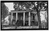 |
November 25, 1969 (#69000209) |
0.8 mi (1.3 km). west of Jefferson on TX 49 32°45′48″N 94°22′12″W / 32.763333°N 94.37°W | Jefferson | Recorded Texas Historic Landmark |
| 6 | Hodge-Taylor House |  |
March 21, 1997 (#97000259) |
Approximately 1 mi (1.6 km) southwest of junction of US 59 and TX 49, W. 32°45′54″N 94°22′20″W / 32.765°N 94.372222°W | Jefferson | |
| 7 | Jefferson Historic District |  |
March 31, 1971 (#71000949) |
Roughly bounded by Owens, Dixon, Walnut, Camp, and Taylor Sts. 32°45′21″N 94°20′46″W / 32.755833°N 94.346111°W | Jefferson | Includes State Antiquities Landmark, Recorded Texas Historic Landmarks |
| 8 | Jefferson Ordnance Magazine |  |
February 17, 1995 (#95000102) |
0.3 mi (0.48 km) northeast of US 59B crossing of Big Cypress Bayou 32°45′29″N 94°20′18″W / 32.758056°N 94.338333°W | Jefferson | Recorded Texas Historic Landmark |
| 9 | Jefferson Playhouse | 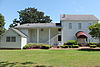 |
October 28, 1969 (#69000374) |
Northwest corner of Market and Henderson Sts. 32°45′25″N 94°20′51″W / 32.756944°N 94.3475°W | Jefferson | Recorded Texas Historic Landmark; part of Jefferson Historic District |
| 10 | The Magnolias |  |
March 31, 1971 (#71000951) |
209 E. Broadway 32°45′42″N 94°21′10″W / 32.761667°N 94.352778°W | Jefferson | Recorded Texas Historic Landmark |
| 11 | Old U.S. Post Office and Courts Building |  |
October 28, 1969 (#69000210) |
223 W. Austin St. 32°45′20″N 94°20′45″W / 32.755556°N 94.345833°W | Jefferson | Recorded Texas Historic Landmark; part of Jefferson Historic District |
| 12 | Capt. William Perry House | 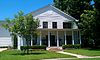 |
August 25, 1970 (#70000755) |
Northwest corner of Walnut and Clarksville Sts. 32°45′38″N 94°20′49″W / 32.760556°N 94.346944°W | Jefferson | Recorded Texas Historic Landmark |
| 13 | Planters Bank Building | 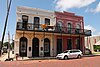 |
March 11, 1971 (#71000952) |
224 E. Austin St. 32°45′26″N 94°20′42″W / 32.757222°N 94.345°W | Jefferson | Recorded Texas Historic Landmark; part of Jefferson Historic District |
| 14 | Presbyterian Manse | 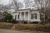 |
October 28, 1969 (#69000211) |
Northeast corner of Alley and Delta Sts. 32°45′27″N 94°21′03″W / 32.7575°N 94.350833°W | Jefferson | Recorded Texas Historic Landmark; part of Jefferson Historic District |
| 15 | Sedberry House | 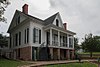 |
August 25, 1970 (#70000756) |
211 N. Market St. 32°45′24″N 94°20′51″W / 32.756667°N 94.3475°W | Jefferson | Recorded Texas Historic Landmark; part of Jefferson Historic District |
| 16 | Capt. William E. Singleton House |  |
August 25, 1970 (#70000757) |
204 N. Soda St. 32°45′37″N 94°21′21″W / 32.760278°N 94.355833°W | Jefferson | Recorded Texas Historic Landmark |
| 17 | Stilley-Young House | 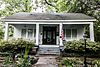 |
September 28, 2005 (#05001105) |
405 Moseley St. 32°45′22″N 94°21′05″W / 32.756111°N 94.351389°W | Jefferson | Recorded Texas Historic Landmark; State Antiquities Landmark |
| 18 | Perry M. Woods House |  |
March 31, 1971 (#71000953) |
502 Walker St. 32°45′33″N 94°21′00″W / 32.759167°N 94.35°W | Jefferson | Recorded Texas Historic Landmark; part of Jefferson Historic District |
See also edit
References edit
- ^ National Park Service, United States Department of the Interior, "National Register of Historic Places: Weekly List Actions", retrieved April 12, 2024.
- ^ The latitude and longitude information provided in this table was derived originally from the National Register Information System, which has been found to be fairly accurate for about 99% of listings. Some locations in this table may have been corrected to current GPS standards.
- ^ Numbers represent an alphabetical ordering by significant words. Various colorings, defined here, differentiate National Historic Landmarks and historic districts from other NRHP buildings, structures, sites or objects.
- ^ "National Register Information System". National Register of Historic Places. National Park Service. November 2, 2013.
- ^ The eight-digit number below each date is the number assigned to each location in the National Register Information System database, which can be viewed by clicking the number.
External links edit
![]() Media related to National Register of Historic Places in Marion County, Texas at Wikimedia Commons
Media related to National Register of Historic Places in Marion County, Texas at Wikimedia Commons