
KNOWPIA
WELCOME TO KNOWPIA

National Register of Historic Places listings in Nance County, Nebraska 
Summary
This is a list of the National Register of Historic Places listings in Nance County, Nebraska. It is intended to be a complete list of the properties and districts on the National Register of Historic Places in Nance County, Nebraska, United States. The locations of National Register properties and districts for which the latitude and longitude coordinates are included below, may be seen in a map.[1]

There are 11 properties and districts listed on the National Register in the county.
This National Park Service list is complete through NPS recent listings posted April 12, 2024.[2]
Current listings edit
| [3] | Name on the Register | Image | Date listed[4] | Location | City or town | Description |
|---|---|---|---|---|---|---|
| 1 | Burkett Archeological Site |  |
July 12, 1974 (#74001133) |
Atop the bluff in the northern half of Section 29, Township 17 North, Range 4 West, 4 miles (6.4 km) southwest of Genoa[5]: 153 41°25′06″N 97°48′00″W / 41.418333°N 97.800000°W | Genoa | |
| 2 | Cottonwood Creek Archeological Site |  |
October 18, 1974 (#74001130) |
Address Restricted | Belgrade | |
| 3 | Cunningham Archeological Site | February 13, 1975 (#75001099) |
Address Restricted | Fullerton | ||
| 4 | Evangelical United Brethren Church | 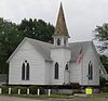 |
September 4, 2013 (#13000678) |
501 Broadway St. 41°21′39″N 97°58′06″W / 41.360917°N 97.968472°W | Fullerton | |
| 5 | Fullerton Archeological Site | November 1, 1974 (#74001131) |
Address Restricted | Fullerton | ||
| 6 | Genoa Site |  |
October 15, 1970 (#70000373) |
Address Restricted | Genoa | |
| 7 | Horse Creek Pawnee Village |  |
July 12, 1974 (#74001132) |
Address Restricted | Fullerton | |
| 8 | Moses Merrill Baptist Camp | April 14, 2004 (#04000295) |
Northwest of Fullerton 41°22′16″N 97°59′06″W / 41.371°N 97.985°W | Fullerton | ||
| 9 | Pawnee Mission and Burnt Village Archeological Site |  |
August 7, 1974 (#74001134) |
Address Restricted | Genoa | |
| 10 | U.S. Indian Industrial School |  |
May 22, 1978 (#78001706) |
Nebraska Highway 22 41°26′58″N 97°43′27″W / 41.44953°N 97.72411°W | Genoa | |
| 11 | Wright Site | August 14, 1973 (#73001069) |
Above Beaver Creek, 1.5 miles (2.4 km) southwest of downtown Genoa[5]: 154 41°26′20″N 97°45′24″W / 41.438889°N 97.756667°W | Genoa |
See also edit
Wikimedia Commons has media related to National Register of Historic Places in Nance County, Nebraska.
References edit
- ^ The latitude and longitude information provided in this table was derived originally from the National Register Information System, which has been found to be fairly accurate for about 99% of listings. Some locations in this table may have been corrected to current GPS standards.
- ^ National Park Service, United States Department of the Interior, "National Register of Historic Places: Weekly List Actions", retrieved April 12, 2024.
- ^ Numbers represent an alphabetical ordering by significant words. Various colorings, defined here, differentiate National Historic Landmarks and historic districts from other NRHP buildings, structures, sites or objects.
- ^ The eight-digit number below each date is the number assigned to each location in the National Register Information System database, which can be viewed by clicking the number.
- ^ a b Grange, Roger T., Jr. "An Archeological View of Pawnee Origins[usurped]". Nebraska History 60 (1979): 134-160.