
KNOWPIA
WELCOME TO KNOWPIA

National Register of Historic Places listings in Nemaha County, Nebraska 
Summary
This is a list of the National Register of Historic Places listings in Nemaha County, Nebraska. It is intended to be a complete list of the properties and districts on the National Register of Historic Places in Nemaha County, Nebraska, United States. The locations of National Register properties and districts for which the latitude and longitude coordinates are included below, may be seen in a map.[1]

There are 13 properties and districts listed on the National Register in the county, including 1 National Historic Landmark.
This National Park Service list is complete through NPS recent listings posted April 12, 2024.[2]
Listings county-wide edit
| [3] | Name on the Register | Image | Date listed[4] | Location | City or town | Description |
|---|---|---|---|---|---|---|
| 1 | Auburn Historic District |  |
July 14, 2014 (#14000396) |
Downtown Commercial District, Courthouse Sq. & Courthouse Ave. 40°23′28″N 95°50′22″W / 40.3911°N 95.8394°W | Auburn | |
| 2 | John W. Bennett House | 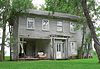 |
September 16, 1983 (#83001099) |
Off Nebraska Highway 67 40°23′31″N 95°40′30″W / 40.39183°N 95.67497°W | Brownville | |
| 3 | Brownville Bridge |  |
June 17, 1993 (#93000536) |
U.S. Route 136 over the Missouri River 40°23′57″N 95°39′06″W / 40.399167°N 95.651667°W | Brownville | Spans Missouri River to Atchison County, Missouri |
| 4 | Brownville Historic District | 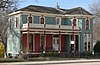 |
May 19, 1970 (#70000374) |
Bounded by Allen, Richard, Nemaha, Nebraska, 7th, and 2nd Sts., and the Missouri River 40°23′52″N 95°39′18″W / 40.397778°N 95.655°W | Brownville | |
| 5 | CAPTAIN MERIWETHER LEWIS (dredge) |  |
October 28, 1977 (#77000833) |
Southeast of Brownville 40°23′41″N 95°39′02″W / 40.394722°N 95.650556°W | Brownville | |
| 6 | First United Presbyterian Church of Auburn | 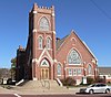 |
July 15, 1982 (#82003199) |
1322 19th St. 40°23′08″N 95°50′37″W / 40.385556°N 95.843611°W | Auburn | |
| 7 | Legion Memorial Park |  |
December 29, 2004 (#04001407) |
Generally bounded by 10th St., 11th St., H St., and J St. 40°23′39″N 95°50′14″W / 40.394167°N 95.837222°W | Auburn | |
| 8 | Thomas J. Majors Farmstead |  |
June 15, 1978 (#78001707) |
West of Peru at 800 Mulberry St. 40°29′04″N 95°44′09″W / 40.484444°N 95.735833°W | Peru | |
| 9 | Nemaha County Courthouse | 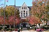 |
January 10, 1990 (#89002243) |
1824 N St. 40°23′08″N 95°50′40″W / 40.385556°N 95.844444°W | Auburn | |
| 10 | New Opera House |  |
September 28, 1988 (#88000936) |
921 Central Ave. 40°23′34″N 95°50′19″W / 40.39265°N 95.83854°W | Auburn | |
| 11 | Wilber T. Reed House | 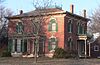 |
March 24, 1980 (#80002458) |
1204 N St. 40°23′33″N 95°50′40″W / 40.39253°N 95.84433°W | Auburn | |
| 12 | St. John's Lutheran Church Complex |  |
January 25, 1979 (#79001452) |
63289 725 Rd.[5] 40°20′00″N 95°57′26″W / 40.33341°N 95.95725°W | Auburn | |
| 13 | US Post Office-Auburn |  |
May 11, 1992 (#92000480) |
1320 Courthouse Ave. 40°23′28″N 95°50′23″W / 40.39101°N 95.83974°W | Auburn | One of 12 Nebraska post offices featuring a Section of Fine Arts mural, "Threshing" (1939) by Ethel Magafan.[6] |
See also edit
Wikimedia Commons has media related to National Register of Historic Places in Nemaha County, Nebraska.
References edit
- ^ The latitude and longitude information provided in this table was derived originally from the National Register Information System, which has been found to be fairly accurate for about 99% of listings. Some locations in this table may have been corrected to current GPS standards.
- ^ National Park Service, United States Department of the Interior, "National Register of Historic Places: Weekly List Actions", retrieved April 12, 2024.
- ^ Numbers represent an alphabetical ordering by significant words. Various colorings, defined here, differentiate National Historic Landmarks and historic districts from other NRHP buildings, structures, sites or objects.
- ^ The eight-digit number below each date is the number assigned to each location in the National Register Information System database, which can be viewed by clicking the number.
- ^ See photo of sign with address
- ^ Ahlgren, Carol (August 1991). "National Register of Historic Places Multiple Property Documentation Form: Nebraska Post Offices Which Contain Section Artwork (1938-1942)" (PDF). Archived from the original on May 13, 2013. Retrieved 2013-01-28.
{{cite journal}}: Cite journal requires|journal=(help)CS1 maint: unfit URL (link)