
KNOWPIA
WELCOME TO KNOWPIA

National Register of Historic Places listings in North Hempstead (town), New York 
Summary
This is a list of all National Register of Historic Places listings in the Town of North Hempstead, New York. The locations of National Register properties for which the latitude and longitude coordinates are included below, may be seen in a Google map.[1]
Listings edit
| [2] | Name on the Register | Image | Date listed[3] | Location | City or town | Description |
|---|---|---|---|---|---|---|
| 1 | William Barstow Mansion | August 29, 2014 (#14000539) |
300 Steamboat Rd. 40°48′54″N 73°45′45″W / 40.8149°N 73.7624°W | Kings Point | Gilded Age mansion built by founder of Kings Point and electricity pioneer now used as American Merchant Marine Museum | |
| 2 | Cedarmere-Clayton Estates | 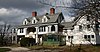 |
September 29, 1986 (#86002634) |
Bryant Avenue and Northern Boulevard 40°48′36″N 73°38′22″W / 40.81°N 73.639444°W | Roslyn Harbor | Home of William Cullen Bryant and, later, Childs Frick; now part of the Nassau County Museum of Art |
| 3 | Clapham-Stern House | 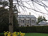 |
June 10, 2005 (#05000570) |
48 Glenwood Road 40°49′15″N 73°38′49″W / 40.820833°N 73.646944°W | Roslyn Harbor | |
| 4 | Clifton |  |
July 22, 1999 (#99000874) |
355 Bryant Avenue 40°48′44″N 73°38′51″W / 40.812222°N 73.6475°W | Roslyn Harbor | |
| 5 | Cornell-Van Nostrand House | August 28, 2007 (#07000863) |
New Hyde Park Road and Marcus Avenue 40°45′33″N 73°41′15″W / 40.759167°N 73.6875°W | New Hyde Park | ||
| 6 | George W. Denton House |  |
August 29, 1985 (#85001937) |
West Shore Road 40°48′16″N 73°39′19″W / 40.804444°N 73.655278°W | Flower Hill | |
| 7 | Thomas Dodge Homestead |  |
June 26, 1986 (#86001387) |
58 Harbor Road 40°50′20″N 73°41′51″W / 40.838889°N 73.6975°W | Port Washington | |
| 8 | East Williston Village Historic District | July 18, 1985 (#85001603) |
Roughly bounded by East Williston Avenue, Roslyn Road, Atlanta Avenue, and Village Green 40°45′28″N 73°38′18″W / 40.757778°N 73.638333°W | East Williston | ||
| 9 | Eastman Cottage | 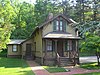 |
October 2, 1986 (#86002635) |
130 Mott Avenue 40°48′09″N 73°39′16″W / 40.8025°N 73.654444°W | Roslyn | |
| 10 | Execution Rocks Light Station | 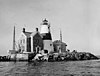 |
February 23, 2007 (#07000094) |
In Long Island Sound, 0.9 mi. NNW of N end of Middle Neck Road in Sands Point, in Nassau County. 40°52′41″N 73°44′17″W / 40.878056°N 73.738056°W | Port Washington | |
| 11 | Gould-Guggenheim Estate | 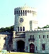 |
September 29, 2006 (#06000881) |
95 Middle Neck Road 40°51′34″N 73°41′47″W / 40.859444°N 73.696389°W | Sands Point | |
| 12 | Grace and Thomaston Buildings | 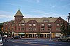 |
December 14, 1978 (#78001865) |
11 Middle Neck Road and 8 Bond Street 40°47′15″N 73°43′40″W / 40.7875°N 73.727778°W | Great Neck Plaza | |
| 13 | Greenridge-Arthur Williams House |  |
July 22, 1999 (#99000875) |
875 Bryant Avenue 40°49′00″N 73°37′49″W / 40.816667°N 73.630278°W | Roslyn Harbor | |
| 14 | Hicks Lumber Company Store |  |
October 2, 1986 (#86002636) |
1345 Old Northern Boulevard 40°48′01″N 73°39′01″W / 40.800278°N 73.650278°W | Roslyn | |
| 15 | William Landsberg House |  |
August 18, 2014 (#14000490) |
5 Tianderah Rd. 40°49′57″N 73°41′41″W / 40.83253°N 73.69470°W | Baxter Estates | Home designed and lived in by NY Architect William Landsberg |
| 16 | Mackay Estate Dairyman's Cottage |  |
March 14, 1991 (#91000238) |
40 Elm Drive 40°48′02″N 73°37′32″W / 40.800556°N 73.625556°W | East Hills | |
| 17 | Mackay Estate Gate Lodge | 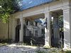 |
March 14, 1991 (#91000240) |
Jct. of Harbor Hill and Roslyn Roads 40°47′35″N 73°38′30″W / 40.793056°N 73.641667°W | East Hills | |
| 18 | Mackay Estate Water Tower |  |
March 14, 1991 (#91000239) |
Redwood Drive between Lincoln Drive and Lufberry Drive 40°47′51″N 73°38′23″W / 40.7975°N 73.639722°W | East Hills | |
| 19 | Main Street Historic District | 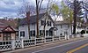 |
January 21, 1974 (#74001266) |
Main Street from North Hempstead Turnpike to East Broadway, including Tower Street and portions of Glen Avenue and Paper Mill Road 40°47′50″N 73°38′56″W / 40.797222°N 73.648889°W | Roslyn | Mostly intact 18th- and 19th-century core of Roslyn |
| 20 | Main Street School | 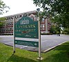 |
February 10, 1983 (#83001714) |
Main and South Washington Streets 40°49′50″N 73°41′48″W / 40.830556°N 73.696667°W | Port Washington | |
| 21 | Manhasset Monthly Meeting of the Society of Friends |  |
September 9, 2009 (#09000700) |
1421 Northern Boulevard 40°47′37″N 73°41′40″W / 40.793628°N 73.694386°W | Manhasset | |
| 22 | Monfort Cemetery |  |
January 7, 1988 (#87002301) |
E of Main Street and Port Washington Boulevard 40°49′52″N 73°40′57″W / 40.831111°N 73.6825°W | Port Washington | Cemetery with remains of some early settlers of Cow Neck area. |
| 23 | Mudge Farmhouse |  |
July 22, 1999 (#99000876) |
535 Motts Cove Road South 40°48′55″N 73°38′13″W / 40.815278°N 73.636944°W | Roslyn Harbor | |
| 24 | North Hempstead Town Hall |  |
December 20, 2006 (#06001143) |
220 Plandome Road 40°47′44″N 73°41′56″W / 40.795556°N 73.698889°W | Manhasset | |
| 25 | Old Westbury Gardens | 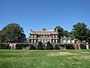 |
November 8, 1976 (#76001234) |
71 Old Westbury Road 40°46′26″N 73°35′47″W / 40.773889°N 73.596389°W | Westbury | |
| 26 | Horatio Gates Onderdonk House |  |
April 16, 1980 (#80002661) |
1471 Northern Boulevard 40°47′38″N 73°41′33″W / 40.793889°N 73.6925°W | Manhasset | |
| 27 | Rescue Hook & Ladder Company No. 1 Firehouse | 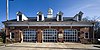 |
May 6, 1991 (#91000480) |
Jct. of School Street and Skillman Street 40°48′10″N 73°38′48″W / 40.802778°N 73.646667°W | Roslyn | |
| 28 | Roslyn Cemetery | 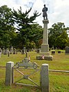 |
October 28, 1991 (#91001534) |
Northern Boulevard, W of jct. with Glen Cove Road 40°48′33″N 73°37′56″W / 40.809167°N 73.632222°W | Greenvale | |
| 29 | Roslyn Grist Mill |  |
October 2, 1986 (#86002638) |
1347 Old Northern Boulevard 40°48′01″N 73°39′00″W / 40.800278°N 73.65°W | Roslyn | One of the few remaining Dutch colonial commercial frame buildings in U.S. |
| 30 | Roslyn House |  |
June 7, 1990 (#90000880) |
Jct. of Lincoln Avenue and Roslyn Road 40°47′31″N 73°38′28″W / 40.791944°N 73.641111°W | Roslyn Heights | |
| 31 | Roslyn National Bank and Trust Company Building |  |
October 2, 1986 (#86002639) |
1432 Old Northern Boulevard 40°48′06″N 73°38′49″W / 40.801803°N 73.646931°W | Roslyn | |
| 32 | Roslyn Savings Bank Building |  |
October 2, 1986 (#86002640) |
1400 Old Northern Boulevard 40°48′03″N 73°38′52″W / 40.800833°N 73.647778°W | Roslyn | |
| 33 | Roslyn Village Historic District |  |
April 15, 1987 (#86002650) |
Roughly bounded by Old Northern Boulevard, Vernon and East Broadway Streets, Main, Glen Avenue, and Tower Street 40°47′49″N 73°38′54″W / 40.796944°N 73.648333°W | Roslyn | Later 19th-century western and commercial portion of Roslyn |
| 34 | Saddle Rock Grist Mill |  |
December 27, 1978 (#78001866) |
Grist Mill Lane and Little Neck Bay 40°47′51″N 73°45′05″W / 40.7975°N 73.751389°W | Saddle Rock | |
| 35 | Saint Mary's Chapel |  |
April 6, 2005 (#05000270) |
Rushmore Avenue bet Roslyn Avenue and Glen Cove Avenue 40°45′04″N 73°36′35″W / 40.751111°N 73.609722°W | Carle Place | |
| 36 | Sands Family Cemetery | March 12, 1992 (#92000092) |
Off Sands Point Road just S of jct. with Middle Neck Road 40°51′29″N 73°43′24″W / 40.858056°N 73.723333°W | Sands Point | ||
| 37 | Sands-Willets Homestead | 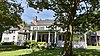 |
September 19, 1985 (#85002425) |
336 Port Washington Boulevard 40°48′56″N 73°40′51″W / 40.815556°N 73.680833°W | Flower Hill | Headquarters of the Cow Neck Peninsula Historical Society. |
| 38 | Almeron and Olive Smith House |  |
July 12, 2006 (#06000569) |
50 South Drive 40°48′23″N 73°42′11″W / 40.806389°N 73.703056°W | Plandome | |
| 39 | Stephen and Charles Smith House |  |
July 22, 1999 (#99000873) |
450 Bryant Avenue 40°48′47″N 73°38′45″W / 40.813056°N 73.645833°W | Roslyn Harbor | |
| 40 | John Philip Sousa House |  |
October 15, 1966 (#66000532) |
14 Hicks Lane, Sands Point 40°50′35″N 73°43′47″W / 40.843056°N 73.729722°W | Port Washington | Home of John Philip Sousa, bandleader and composer of memorable marches, from 1915 to his death |
| 41 | Springbank | 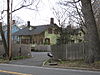 |
September 9, 1999 (#99001128) |
440 Bryant Avenue 40°48′46″N 73°38′45″W / 40.812778°N 73.645833°W | Roslyn Harbor | |
| 42 | Stepping Stones Light Station |  |
September 15, 2005 (#05001026) |
Long Island Sound, 0.9 mi. NW of Elm Point in the Incorporated Village of Kings Point 40°49′27″N 73°46′30″W / 40.824167°N 73.775°W | Kings Point | |
| 43 | Willet Titus House | October 2, 1986 (#86002652) |
1441 Old Northern Boulevard 40°48′11″N 73°38′50″W / 40.803056°N 73.647222°W | Roslyn | ||
| 44 | Toll Gate House |  |
August 16, 1977 (#77000952) |
Northern Boulevard 40°48′31″N 73°37′56″W / 40.808611°N 73.632222°W | Greenvale | |
| 45 | Trinity Church Complex | 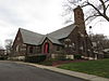 |
October 2, 1986 (#86002653) |
Northern Boulevard 40°48′18″N 73°38′44″W / 40.805°N 73.645556°W | Roslyn | |
| 46 | United States Merchant Marine Academy | 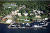 |
August 29, 2014 (#14000538) |
300 Steamboat Road 40°48′44″N 73°45′48″W / 40.81219°N 73.76345°W | Kings Point | Training site for members of the U.S. Merchant Marine since 1943 |
| 47 | US Post Office-Great Neck | 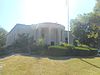 |
May 11, 1989 (#88002526) |
1 Welwyn Road 40°47′14″N 73°43′23″W / 40.787222°N 73.723056°W | Great Neck Plaza | |
| 48 | US Post Office-Mineola |  |
May 11, 1989 (#88002354) |
Main and First Streets 40°44′35″N 73°38′21″W / 40.743056°N 73.639167°W | Mineola | Only federal project designed by Peabody, Wilson & Brown, and rare New Deal post office without public art in lobby. |
| 49 | Valley Road Historic District | April 8, 1977 (#77000953) |
S of Manhasset on Community Drive 40°46′27″N 73°42′14″W / 40.774167°N 73.703889°W | Manhasset | ||
| 50 | Samuel Adams Warner House |  |
October 2, 1986 (#86002654) |
1 Railroad Avenue 40°47′34″N 73°38′39″W / 40.792778°N 73.644167°W | Roslyn | |
| 51 | Willowmere | 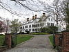 |
July 22, 1999 (#99000872) |
435 Bryant Avenue 40°48′55″N 73°38′48″W / 40.815278°N 73.646667°W | Roslyn Harbor |
See also edit
References edit
- ^ The latitude and longitude information provided is primarily from the National Register Information System, and has been found to be fairly accurate for about 99% of listings. For 1%, the location info may be way off. We seek to correct the coordinate information wherever it is found to be erroneous. Please leave a note in the Discussion page for this article if you believe any specific location is incorrect.
- ^ Numbers represent an alphabetical ordering by significant words. Various colorings, defined here, differentiate National Historic Landmarks and historic districts from other NRHP buildings, structures, sites or objects.
- ^ The eight-digit number below each date is the number assigned to each location in the National Register Information System database, which can be viewed by clicking the number.