
KNOWPIA
WELCOME TO KNOWPIA

National Register of Historic Places listings in Portage County, Ohio 
Summary
This is a list of the National Register of Historic Places listings in Portage County, Ohio.

This is intended to be a complete list of the properties and districts on the National Register of Historic Places in Portage County, Ohio, United States. The locations of National Register properties and districts for which the latitude and longitude coordinates are included below, may be seen in an online map.[1]
There are 49 properties and districts listed on the National Register in the county. Another 2 properties were once listed but have been removed.
This National Park Service list is complete through NPS recent listings posted April 12, 2024.[2]
Current listings edit
| [3] | Name on the Register[4] | Image | Date listed[5] | Location | City or town | Description |
|---|---|---|---|---|---|---|
| 1 | Atwater Congregational Church |  |
February 23, 1973 (#73001517) |
1237 State Route 183 at Atwater 41°01′21″N 81°08′12″W / 41.0225°N 81.136667°W | Atwater Township | |
| 2 | Aurora Center Historic District |  |
June 20, 1974 (#74001601) |
Roughly both sides of State Route 306 from and including Pioneer Trail to State Route 82, also Maple Lane 41°18′49″N 81°20′50″W / 41.313611°N 81.347222°W | Aurora | |
| 3 | Aurora Train Station |  |
May 22, 1986 (#86001131) |
13 New Hudson Rd. 41°19′01″N 81°20′00″W / 41.316806°N 81.333333°W | Aurora | |
| 4 | Horace Y. Beebe House |  |
June 16, 1983 (#83002022) |
6538 Cleveland Rd., northwest of Ravenna 41°10′07″N 81°15′19″W / 41.168611°N 81.255278°W | Ravenna Township | |
| 5 | John F. Byers House |  |
July 2, 2008 (#08000590) |
5551 S. Prospect St., south of Ravenna 41°08′31″N 81°14′33″W / 41.141806°N 81.242611°W | Ravenna Township | |
| 6 | Cleveland Worsted Mills Redfern Mill |  |
December 29, 1988 (#88003065) |
S. Chestnut St. 41°08′58″N 81°14′37″W / 41.149444°N 81.243611°W | Ravenna | |
| 7 | Cottage Hill Farm |  |
May 6, 1993 (#93000401) |
5555 Newton Falls Rd., east of Ravenna 41°09′54″N 81°11′45″W / 41.165000°N 81.195833°W | Ravenna Township | |
| 8 | William H. Crafts House |  |
April 29, 1982 (#82003634) |
4619 W. Prospect St. 41°16′56″N 81°13′33″W / 41.282222°N 81.225833°W | Mantua | |
| 9 | Crystal Lake Stock Farm |  |
April 10, 1986 (#86000698) |
4655 Hayes Rd., southeast of Ravenna 41°08′15″N 81°13′35″W / 41.1375°N 81.226389°W | Ravenna Township | |
| 10 | John Davey House |  |
May 29, 1975 (#75001524) |
338 Woodard St. 41°09′31″N 81°21′55″W / 41.158611°N 81.365278°W | Kent | |
| 11 | John Diver House and Storebuilding |  |
September 16, 1982 (#82003632) |
9465 Akron-Canfield Rd. at Deerfield 41°01′29″N 81°02′59″W / 41.024722°N 81.049722°W | Deerfield Township | |
| 12 | East Main Street Historic District | 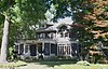 |
October 10, 1985 (#85003123) |
E. Main St. between Clinton and Linden Sts. 41°09′26″N 81°14′03″W / 41.157222°N 81.234167°W | Ravenna | |
| 13 | Ellenwood House |  |
June 20, 1975 (#75001523) |
Northwest of Garrettsville on State Route 82 41°17′32″N 81°06′46″W / 41.292222°N 81.112778°W | Hiram Township | |
| 14 | Etna House |  |
July 25, 1985 (#85001641) |
219½ W. Main St. 41°09′26″N 81°14′38″W / 41.157222°N 81.243889°W | Ravenna | |
| 15 | Aaron Ferrey House |  |
August 13, 1974 (#74001605) |
5058 Sunnybrook Rd. 41°07′38″N 81°21′55″W / 41.127222°N 81.365278°W | Kent | |
| 16 | Franklin Hotel |  |
January 18, 2013 (#12000802) |
176 E. Main St. 41°09′12″N 81°21′24″W / 41.15343°N 81.356637°W | Kent | |
| 17 | Franklin Township Hall |  |
October 10, 1975 (#75001525) |
218 Gougler Ave. 41°09′19″N 81°21′38″W / 41.155278°N 81.360556°W | Kent | |
| 18 | Freedom Congregational Church |  |
July 7, 1975 (#75001521) |
Public Green on State Route 88 at Freedom 41°14′07″N 81°08′50″W / 41.235278°N 81.147222°W | Freedom Township | |
| 19 | James A. Garfield House |  |
January 30, 1975 (#09000098) |
6825 Hinsdale St. 41°18′47″N 81°08′41″W / 41.313194°N 81.144722°W | Hiram | |
| 20 | A.B. Griffin-O.H. Griffin House |  |
March 7, 1985 (#85000485) |
409 S. Walnut St. 41°09′16″N 81°14′25″W / 41.154444°N 81.240278°W | Ravenna | |
| 21 | Alexander B. Griffin House | 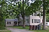 |
July 2, 1987 (#87000987) |
417 S. Walnut St. 41°09′16″N 81°14′23″W / 41.154306°N 81.239722°W | Ravenna | |
| 22 | L.N. Gross Company Building |  |
September 2, 2016 (#16000598) |
315 Gougler Ave. 41°09′23″N 81°21′36″W / 41.156258°N 81.360076°W | Kent | |
| 23 | Horace L. Hine House |  |
December 12, 1976 (#76001513) |
4624 W. Prospect St. 41°16′54″N 81°13′32″W / 41.281667°N 81.225556°W | Mantua | |
| 24 | Benjamin F. Hopkins Stone Building | 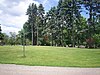 |
November 25, 1982 (#82003633) |
Standing Rock Cemetery 41°09′55″N 81°21′11″W / 41.165278°N 81.353056°W | Kent | Dismantled |
| 25 | C.R. Howard House |  |
August 13, 1974 (#74001602) |
411 E. Garfield St. 41°19′04″N 81°19′51″W / 41.317778°N 81.330833°W | Aurora | |
| 26 | John Johnson Farm | 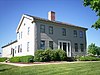 |
December 12, 1976 (#76001512) |
6203 Pioneer Trail, southwest of Hiram 41°17′48″N 81°10′05″W / 41.296667°N 81.168056°W | Hiram Township | |
| 27 | Kent Industrial District |  |
December 30, 1974 (#74001603) |
Roughly bounded by West Main and River Streets, Haymaker Parkway, and Franklin Avenue 41°09′11″N 81°21′37″W / 41.153056°N 81.360278°W | Kent | |
| 28 | Kent Jail |  |
August 22, 2001 (#01000895) |
947 Middlebury Rd. 41°09′00″N 81°22′07″W / 41.15°N 81.368611°W | Kent | Listed in 1978 at 124 W. Day St., but removed in 2000 before relisting at current location in 2001[4] |
| 29 | Charles Kent House |  |
February 23, 1978 (#78002174) |
125 N. Pearl St. 41°09′15″N 81°21′56″W / 41.154167°N 81.365556°W | Kent | |
| 30 | Zeno Kent House |  |
April 23, 1973 (#73001518) |
2.5 mi (4.0 km) southwest of central Aurora on Aurora-Hudson Rd. 41°17′04″N 81°21′48″W / 41.284306°N 81.363333°W | Aurora | |
| 31 | Kent State Shootings Site |  |
February 23, 2010 (#10000046) |
0.5 miles (0.80 km) southeast of the intersection of E. Main St. and S. Lincoln St. 41°09′00″N 81°20′40″W / 41.15°N 81.344444°W | Kent | Site of May 4, 1970, shootings of Vietnam War protesters by Ohio National Guardsmen that killed four. |
| 32 | Mantua Center District |  |
October 9, 1974 (#74001607) |
Roughly bounded by State Route 82 and Mantua Center Rd., in Mantua Center; also 4103-3991 State Route 82, 11670-11755 Mantua Center Road, 11653- 11677 Diagonal Road, 11701-11715 School Lane 41°18′35″N 81°14′42″W / 41.309722°N 81.245°W | Mantua Township | Second set of addresses represent a boundary increase approved November 28, 2023. |
| 33 | Mantua Center School |  |
September 4, 2013 (#13000682) |
11741 Mantua Center Rd. at Mantua Center 41°18′41″N 81°14′42″W / 41.311389°N 81.245000°W | Mantua Township | |
| 34 | Mantua Station Brick Commercial District |  |
December 24, 1974 (#74001606) |
Main and Prospect Sts. 41°16′54″N 81°13′26″W / 41.281667°N 81.223889°W | Mantua | |
| 35 | Masonic Temple |  |
July 18, 1974 (#74001604) |
409 W. Main St. 41°09′15″N 81°21′47″W / 41.154167°N 81.363056°W | Kent | |
| 36 | Mott Drug Store |  |
February 29, 1996 (#96000221) |
8107 Main St. 41°17′05″N 81°05′52″W / 41.284861°N 81.097639°W | Garrettsville | |
| 37 | Luman Nelson House |  |
December 22, 1993 (#93001393) |
8219 State Route 44, north of Ravenna 41°12′53″N 81°14′33″W / 41.214722°N 81.2425°W | Shalersville Township | |
| 38 | Ohio State Normal College at Kent |  |
May 30, 1975 (#75001526) |
Hilltop Dr. on the Kent State University campus 41°09′06″N 81°20′53″W / 41.151667°N 81.348056°W | Kent | |
| 39 | Arvin Olin House |  |
October 20, 1995 (#95001157) |
1423 Ravenna Rd., north of Kent 41°11′02″N 81°20′33″W / 41.183889°N 81.3425°W | Franklin Township | Demolished by the city of Akron on 10 March 2010[6] |
| 40 | Palmyra Center Hotel |  |
April 30, 1976 (#76001514) |
County Road 18 and State Route 225 at Palmyra Center 41°05′57″N 81°03′07″W / 41.099167°N 81.051944°W | Palmyra Township | |
| 41 | Phoenix Block |  |
March 18, 1985 (#85000624) |
Northeastern corner of Main and Chestnut Sts. 41°09′28″N 81°14′37″W / 41.157778°N 81.243611°W | Ravenna | |
| 42 | C.A. Reed House |  |
October 10, 1985 (#85003116) |
229 W. Riddle St. 41°09′18″N 81°14′41″W / 41.155000°N 81.244722°W | Ravenna | |
| 43 | Riddle Block | 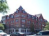 |
March 17, 1976 (#76001515) |
Public Sq., Chestnut, and Main Sts. 41°09′26″N 81°14′35″W / 41.157222°N 81.243056°W | Ravenna | |
| 44 | Riddle Block No. 5 |  |
July 25, 1985 (#85001642) |
141-145 E. Main St. 41°09′28″N 81°14′30″W / 41.157778°N 81.241667°W | Ravenna | |
| 45 | Riddle Block No. 9 |  |
March 18, 1985 (#85000625) |
113-115 W. Main St. 41°09′28″N 81°14′37″W / 41.157778°N 81.243611°W | Ravenna | |
| 46 | Riddle Block No. 11 | 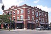 |
March 18, 1985 (#85000626) |
133-137 E. Main St. 41°09′28″N 81°14′32″W / 41.157778°N 81.242222°W | Ravenna | |
| 47 | Frederick Wadsworth House |  |
May 29, 1975 (#75001520) |
4889 State Route 14, northwest of Edinburg 41°07′21″N 81°10′48″W / 41.1225°N 81.18°W | Edinburg Township | |
| 48 | West Main Street District | 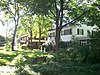 |
June 17, 1977 (#77001082) |
409-625 W. Main St. 41°09′14″N 81°21′56″W / 41.153889°N 81.365556°W | Kent | |
| 49 | Thomas F. Young House |  |
October 22, 1976 (#76001511) |
Wakefield and Garfield Sts. 41°18′35″N 81°08′40″W / 41.309722°N 81.144444°W | Hiram |
Former listings edit
| [3] | Name on the Register | Image | Date listed | Date removed | Location | City or town | Description |
|---|---|---|---|---|---|---|---|
| 1 | Brown-Kent Tannery | October 2, 1973 (#73002290) | September 30, 1976 | Stow St. | Kent | Demolished on June 2, 1976.[7] | |
| 2 | Cascade House | July 1, 1975 (#75001522) | Unknown | Northeast of Garrettsville on State Route 282 in Nelson Ledge State Park | Garrettsville | Demolished in 1980. |
See also edit
Wikimedia Commons has media related to National Register of Historic Places in Portage County, Ohio.
- List of National Historic Landmarks in Ohio
- Listings in neighboring counties: Cuyahoga, Geauga, Mahoning, Stark, Summit, Trumbull
- National Register of Historic Places listings in Ohio
References edit
- ^ The latitude and longitude information provided in this table was derived originally from the National Register Information System, which has been found to be fairly accurate for about 99% of listings. Some locations in this table may have been corrected to current GPS standards.
- ^ National Park Service, United States Department of the Interior, "National Register of Historic Places: Weekly List Actions", retrieved April 12, 2024.
- ^ a b Numbers represent an alphabetical ordering by significant words. Various colorings, defined here, differentiate National Historic Landmarks and historic districts from other NRHP buildings, structures, sites or objects.
- ^ a b "National Register Information System". National Register of Historic Places. National Park Service. April 24, 2008.
- ^ The eight-digit number below each date is the number assigned to each location in the National Register Information System database, which can be viewed by clicking the number.
- ^ Fredmonsky, Matt. 175-year-old home razed: Historic Olin House in Franklin Township was owned by Akron, Record Courier, 2010-03-11. Accessed 2010-03-11.
- ^ "John Brown tannery razed". The Akron Beacon Journal. June 3, 1976. p. B2. Retrieved August 15, 2022 – via Newspapers.com.