


Summary
This is a list of the National Register of Historic Places listings in Potter County, Texas
This is intended to be a complete list of properties and districts listed on the National Register of Historic Places in Potter County, Texas. Five districts including one national monument and 32 individual properties are listed on the National Register in the county. Thirteen of the county's Recorded Texas Historic Landmarks are included in the National Register.
This National Park Service list is complete through NPS recent listings posted April 12, 2024.[1]
Current listings edit
The publicly disclosed locations of National Register properties and districts may be seen in a mapping service provided.[2]
| [3] | Name on the Register | Image | Date listed[4] | Location | City or town | Description |
|---|---|---|---|---|---|---|
| 1 | Alibates Flint Quarries National Monument |  |
October 15, 1966 (#66000822) |
SW of Fritch on the Canadian River 35°34′56″N 101°40′19″W / 35.582092°N 101.672078°W | Fritch | |
| 2 | Amarillo Building |  |
February 23, 2018 (#100002131) |
301 S Polk 35°12′38″N 101°50′11″W / 35.210624°N 101.836449°W | Amarillo | |
| 3 | Amarillo College Administration Building and Gymnasium |  |
January 28, 1992 (#91002023) |
2201 S. Washington St. and 2221 S. Washington St. 35°11′18″N 101°50′53″W / 35.188335°N 101.848164°W | Amarillo | Recorded Texas Historic Landmarks |
| 4 | Amarillo US Post Office and Courthouse |  |
September 29, 2000 (#00001175) |
205 E. Fifth St. 35°12′31″N 101°50′03″W / 35.208611°N 101.834167°W | Amarillo | |
| 5 | American National Bank of Amarillo and SPS Tower |  |
March 6, 2019 (#100003493) |
600 S. Tyler St. 35°12′26″N 101°50′19″W / 35.207353°N 101.838623°W | Amarillo | |
| 6 | Atchison, Topeka and Santa Fe Railway Company Depot and Locomotive No. 5000 | 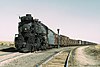 |
September 18, 1986 (#86002189) |
Corner of 2nd and Lincoln 35°12′31″N 101°49′36″W / 35.208611°N 101.826667°W | Amarillo | Moved from original location at 307 S Grant in 2005[5] |
| 7 | Bivins House | 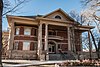 |
December 31, 1974 (#74002088) |
1000 Polk St. 35°12′11″N 101°50′17″W / 35.203056°N 101.838056°W | Amarillo | Recorded Texas Historic Landmark |
| 8 | Miles and Myda Bivins House |  |
October 2, 1992 (#92001306) |
2311 W. 16th Ave. 35°11′49″N 101°51′47″W / 35.196944°N 101.863056°W | Amarillo | |
| 9 | Central Presbyterian Church |  |
November 13, 1991 (#91001649) |
1100 S Harrison St 35°12′10″N 101°50′26″W / 35.202778°N 101.840556°W | Amarillo | |
| 10 | Alice Ghormley Curtis House |  |
August 14, 1992 (#92000980) |
1626 S. Washington St. 35°11′48″N 101°50′54″W / 35.196667°N 101.848333°W | Amarillo | Recorded Texas Historic Landmark |
| 11 | Douglas DC-3 Airplane, N34 |  |
May 29, 1997 (#97000443) |
Texas Air & Space Museum, 10001 American Drive 35°12′48″N 101°42′53″W / 35.2133°N 101.7148°W | Amarillo | relocated from Oklahoma City in 2014[6] |
| 12 | First Baptist Church |  |
June 21, 1983 (#83003158) |
218 W. 13th St. 35°12′04″N 101°50′22″W / 35.201111°N 101.839444°W | Amarillo | |
| 13 | Fisk Medical Arts Building | 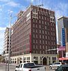 |
December 4, 2012 (#12001003) |
724 S. Polk St. 35°12′21″N 101°50′16″W / 35.20584°N 101.83774°W | Amarillo | Recorded Texas Historic Landmark, now a Courtyard by Marriott hotel |
| 14 | Green Acres Apartments | March 21, 2024 (#100010122) |
3118 SW 15th Ave. 35°11′59″N 101°52′17″W / 35.1997°N 101.8714°W | Amarillo | ||
| 15 | Herring Hotel |  |
January 25, 2024 (#100009886) |
311 SE 3rd Avenue 35°12′37″N 101°49′59″W / 35.2104°N 101.8330°W | Amarillo | |
| 16 | Jons-Gilvin House | 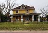 |
August 14, 1992 (#92000983) |
1500 S. Buchanan St. 35°11′51″N 101°50′01″W / 35.1975°N 101.833611°W | Amarillo | |
| 17 | Kouns-Jackson House |  |
August 14, 1992 (#92000981) |
1118 S. Harrison St. 35°12′07″N 101°50′26″W / 35.201944°N 101.840556°W | Amarillo | |
| 18 | Landergin-Harrington House |  |
December 16, 1977 (#77001466) |
1600 Polk St. 35°11′49″N 101°50′20″W / 35.196944°N 101.838889°W | Amarillo | |
| 19 | Levine's Department Store |  |
December 27, 2016 (#16000917) |
800 S. Polk St. 35°12′19″N 101°50′16″W / 35.205408°N 101.837868°W | Amarillo | |
| 20 | McBride Canyon Ruin |  |
July 5, 1985 (#85001483) |
Address restricted[7] | Fritch | |
| 21 | McBride Ranch House | 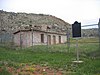 |
April 23, 1975 (#75000152) |
North of Amarillo in Lake Meredith National Recreation Area 35°32′29″N 101°43′44″W / 35.541389°N 101.728889°W | Amarillo | Recorded Texas Historic Landmark |
| 22 | McMillen Apartments |  |
April 2, 2010 (#10000145) |
1320 S. Fillmore 35°11′58″N 101°50′11″W / 35.199444°N 101.836389°W | Amarillo | |
| 23 | Northwest Texas Hospital School of Nursing | 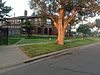 |
November 7, 1996 (#96001234) |
2209 W. 6th Ave. 35°12′32″N 101°55′39″W / 35.208889°N 101.9275°W | Amarillo | Recorded Texas Historic Landmark |
| 24 | Oliver-Eakle-Barfield Building |  |
January 11, 2019 (#100003302) |
600 S. Polk St. 35°12′27″N 101°50′19″W / 35.207477°N 101.838626°W | Amarillo | |
| 25 | Plemons-Mrs. M. D. Oliver-Eakle Additions Historic District |  |
April 21, 1992 (#92000370) |
Roughly bounded by 16th Ave., Taylor St., 26th Ave., Van Buren St., I-40 and Madison St. 35°11′29″N 101°50′33″W / 35.191389°N 101.8425°W | Amarillo | |
| 26 | Polk Street Methodist Church |  |
January 28, 1992 (#91002021) |
1401 S. Polk St. 35°11′56″N 101°50′17″W / 35.198889°N 101.838056°W | Amarillo | Recorded Texas Historic Landmark |
| 27 | Potter County Courthouse and Library | 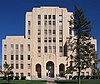 |
August 22, 1996 (#96000938) |
501 S. Taylor St. 35°12′29″N 101°50′06″W / 35.208056°N 101.835°W | Amarillo | Recorded Texas Historic Landmarks |
| 28 | Ranchotel |  |
April 14, 1995 (#95000411) |
2501 W. Sixth Ave. 35°12′40″N 101°51′54″W / 35.211154°N 101.865125°W | Amarillo | |
| 29 | St. Anthony's Hospital | January 14, 2021 (#100006047) |
200 NW 7th Ave. 35°13′13″N 101°50′09″W / 35.2203°N 101.8358°W | Amarillo | ||
| 30 | Henry B. and Ellen M. Sanborn House |  |
August 14, 1992 (#92000982) |
1311 S. Madison St. 35°11′59″N 101°50′25″W / 35.199722°N 101.840278°W | Amarillo | Recorded Texas Historic Landmark |
| 31 | Santa Fe Building | 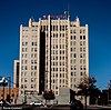 |
August 22, 1996 (#96000939) |
900 S. Polk St. 35°12′16″N 101°50′15″W / 35.204444°N 101.8375°W | Amarillo | Recorded Texas Historic Landmark |
| 32 | Shelton-Houghton House |  |
August 29, 1980 (#80004145) |
1700 S Polk St 35°11′42″N 101°50′22″W / 35.195°N 101.839444°W | Amarillo | Recorded Texas Historic Landmark |
| 33 | Louis H. Smith Inc. Firestone Store |  |
July 21, 2015 (#15000451) |
1004 South Tyler Street 35°12′12″N 101°50′22″W / 35.203464°N 101.839572°W | Amarillo | |
| 34 | Triangle Motel |  |
December 7, 2010 (#10000982) |
7804, 7808, 7954, and 8024 E. Amarillo Blvd. 35°13′20″N 101°44′52″W / 35.222222°N 101.747778°W | Amarillo | Route 66 in Texas MPS |
| 35 | US Route 66-Sixth Street Historic District |  |
August 23, 1994 (#94000982) |
Sixth Ave. between Georgia and Forrest Aves. 35°12′40″N 101°52′24″W / 35.211111°N 101.873333°W | Amarillo | |
| 36 | Vineyard Manor | 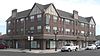 |
November 26, 2014 (#14000965) |
1201 S. Polk Street 35°12′04″N 101°50′17″W / 35.201222°N 101.838074°W | Amarillo | |
| 37 | Wolflin Historic District | May 21, 1992 (#92000581) |
Roughly bounded by Wolflin Ave., Washington St., SW. 34th Ave., Parker St., SW. 30th Ave. and Lipscomb St. 35°11′07″N 101°51′07″W / 35.185278°N 101.851944°W | Amarillo |
See also edit
References edit
- ^ National Park Service, United States Department of the Interior, "National Register of Historic Places: Weekly List Actions", retrieved April 12, 2024.
- ^ The latitude and longitude information provided in this table was derived originally from the National Register Information System, which has been found to be fairly accurate for about 99% of listings. Some locations in this table may have been corrected to current GPS standards.
- ^ Numbers represent an alphabetical ordering by significant words. Various colorings, defined here, differentiate National Historic Landmarks and historic districts from other NRHP buildings, structures, sites or objects.
- ^ The eight-digit number below each date is the number assigned to each location in the National Register Information System database, which can be viewed by clicking the number.
- ^ Santa Fe Preserved Locomotives
- ^ Texas Air and Space Museum
- ^ Federal and state laws and practices restrict general public access to information regarding the specific location of this resource. In some cases, this is to protect archeological sites from vandalism, while in other cases it is restricted at the request of the owner. See: Knoerl, John; Miller, Diane; Shrimpton, Rebecca H. (1990), Guidelines for Restricting Information about Historic and Prehistoric Resources, National Register Bulletin, National Park Service, U.S. Department of the Interior, OCLC 20706997.
External links edit
![]() Media related to National Register of Historic Places in Potter County, Texas at Wikimedia Commons
Media related to National Register of Historic Places in Potter County, Texas at Wikimedia Commons