
KNOWPIA
WELCOME TO KNOWPIA

National Register of Historic Places listings in Radford, Virginia 
Summary
This is a list of the National Register of Historic Places listings in Radford, Virginia.

This is intended to be a complete list of the properties and districts on the National Register of Historic Places in the independent city of Radford, Virginia, United States. The locations of National Register properties and districts for which the latitude and longitude coordinates are included below, may be seen in a Google map.[1]
There are 8 properties and districts listed on the National Register in the city, including 1 National Historic Landmark.
This National Park Service list is complete through NPS recent listings posted April 5, 2024.[2]
Current listings edit
| [3] | Name on the Register[4] | Image | Date listed[5] | Location | Description |
|---|---|---|---|---|---|
| 1 | Arnheim |  |
May 30, 2002 (#02000589) |
40 Dalton Dr. 37°08′11″N 80°34′08″W / 37.136389°N 80.568889°W |
|
| 2 | East Radford Historic District |  |
May 11, 2000 (#00000491) |
Norwood, Stockton, and Downey Sts., and Grove Ave. 37°08′23″N 80°33′24″W / 37.139722°N 80.556667°W |
|
| 3 | Glencoe | 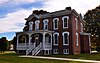 |
November 22, 2000 (#00001439) |
600 Unruh Drive 37°07′56″N 80°34′50″W / 37.132361°N 80.580417°W |
|
| 4 | Halwyck |  |
August 29, 1997 (#97001074) |
915 Tyler Ave. 37°07′55″N 80°32′55″W / 37.131944°N 80.548611°W |
|
| 5 | Harvey House | 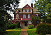 |
July 30, 1976 (#76002228) |
706 Harvey St. 37°07′41″N 80°34′12″W / 37.128194°N 80.570000°W |
|
| 6 | Ingles Bottom Archeological Sites |  |
December 5, 1978 (#78003032) |
On the New River across from Ingles Ferry[6] 37°06′13″N 80°35′01″W / 37.103611°N 80.583611°W |
|
| 7 | La Riviere |  |
August 16, 1994 (#94000991) |
5 Ingles St. 37°06′58″N 80°35′38″W / 37.116111°N 80.593889°W |
|
| 8 | West Radford Commercial Historic District |  |
January 19, 2005 (#04001541) |
100, 200, and 300 blocks of W. Main St. 37°08′04″N 80°34′28″W / 37.134444°N 80.574444°W |
See also edit
Wikimedia Commons has media related to National Register of Historic Places in Radford, Virginia.
References edit
- ^ The latitude and longitude information provided in this table was derived originally from the National Register Information System, which has been found to be fairly accurate for about 99% of listings. Some locations in this table may have been corrected to current GPS standards.
- ^ National Park Service, United States Department of the Interior, "National Register of Historic Places: Weekly List Actions", retrieved April 5, 2024.
- ^ Numbers represent an alphabetical ordering by significant words. Various colorings, defined here, differentiate National Historic Landmarks and historic districts from other NRHP buildings, structures, sites or objects.
- ^ "National Register Information System". National Register of Historic Places. National Park Service. April 24, 2008.
- ^ The eight-digit number below each date is the number assigned to each location in the National Register Information System database, which can be viewed by clicking the number.
- ^ Loth, Calder, ed. The Virginia Landmarks Register. Charlottesville: University of Virginia Press, 414.