
KNOWPIA
WELCOME TO KNOWPIA

National Register of Historic Places listings in Richland County, North Dakota 
Summary
This is a list of the National Register of Historic Places listings in Richland County, North Dakota.
This is intended to be a complete list of the properties and districts on the National Register of Historic Places in Richland County, North Dakota, United States. The locations of National Register properties and districts for which the latitude and longitude coordinates are included below, may be seen in a map.[1]
There are 12 properties and districts listed on the National Register in the county.
| Adams | Barnes | Benson | Billings | Bottineau | Bowman | Burke | Burleigh | Cass | Cavalier | Dickey | Divide | Dunn | Eddy | Emmons | Foster | Golden Valley | Grand Forks | Grant | Griggs | Hettinger | Kidder | LaMoure | Logan | McHenry | McIntosh | McKenzie | McLean | Mercer | Morton | Mountrail | Nelson | Oliver | Pembina | Pierce | Ramsey | Ransom | Renville | Richland | Rolette | Sargent | Sheridan | Sioux | Slope | Stark | Steele | Stutsman | Towner | Traill | Walsh | Ward | Wells | Williams |
This National Park Service list is complete through NPS recent listings posted April 5, 2024.[2]
Current listings edit
| [3] | Name on the Register | Image | Date listed[4] | Location | City or town | Description |
|---|---|---|---|---|---|---|
| 1 | Adams-Fairview Bonanza Farm | 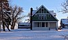 |
November 20, 1990 (#90001838) |
17170 82 R Street, S.E. 46°13′29″N 96°49′01″W / 46.224722°N 96.816944°W | Wahpeton | |
| 2 | Fort Abercrombie | 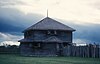 |
January 22, 2009 (#08001367) |
Richland County Route 4 46°26′40″N 96°43′08″W / 46.4445°N 96.718811°W | Abercrombie | First permanent military settlement in what would become North Dakota (1858) |
| 3 | Frederick A. and Sophia Bagg Bonanza Farm | 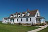 |
November 14, 1985 (#85002832) |
Off ND 13 on Section Road, 32 RI 5 46°15′11″N 96°51′57″W / 46.253056°N 96.865833°W | Mooreton | |
| 4 | Leach Public Library | 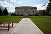 |
January 26, 1990 (#89002303) |
417 Second Avenue North 46°15′53″N 96°36′22″W / 46.264722°N 96.606111°W | Wahpeton | |
| 5 | Nelson's Grocery |  |
October 5, 1977 (#77001027) |
Main and Third Streets 46°34′28″N 96°48′22″W / 46.574444°N 96.806111°W | Christine | |
| 6 | Post Office | 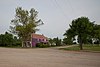 |
October 5, 1977 (#77001028) |
Main and Third Streets 46°34′30″N 96°48′21″W / 46.575°N 96.805833°W | Christine | |
| 7 | Red River Valley University | 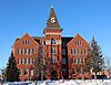 |
April 26, 1984 (#84002770) |
North Sixth Street 46°16′27″N 96°36′28″W / 46.274167°N 96.607778°W | Wahpeton | |
| 8 | Richland County Courthouse | 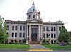 |
November 25, 1980 (#80002926) |
Off ND 13 46°16′03″N 96°36′23″W / 46.2675°N 96.606389°W | Wahpeton | |
| 9 | South Wild Rice Church | 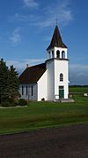 |
October 22, 1982 (#82001345) |
Southeast of Galchutt at U.S. Route 81 and County Road 8 46°23′01″N 96°44′11″W / 46.383611°N 96.736389°W | Galchutt | |
| 10 | St. Alban's Episcopal Church | December 3, 1992 (#92001607) |
Southwestern corner of the junction of Hammond and Eastern Aves. 46°04′32″N 97°08′43″W / 46.075556°N 97.145278°W | Lidgerwood | ||
| 11 | US Post Office-Wahpeton | 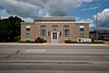 |
November 1, 1989 (#89001759) |
620 Dakota Avenue 46°15′51″N 96°36′30″W / 46.264167°N 96.608333°W | Wahpeton | |
| 12 | Wahpeton Hospital |  |
September 29, 1983 (#83001940) |
720-722 Dakota Avenue 46°15′51″N 96°36′38″W / 46.264167°N 96.610556°W | Wahpeton |
See also edit
Wikimedia Commons has media related to National Register of Historic Places in Richland County, North Dakota.
References edit
- ^ The latitude and longitude information provided in this table was derived originally from the National Register Information System, which has been found to be fairly accurate for about 99% of listings. Some locations in this table may have been corrected to current GPS standards.
- ^ National Park Service, United States Department of the Interior, "National Register of Historic Places: Weekly List Actions", retrieved April 5, 2024.
- ^ Numbers represent an alphabetical ordering by significant words. Various colorings, defined here, differentiate National Historic Landmarks and historic districts from other NRHP buildings, structures, sites or objects.
- ^ The eight-digit number below each date is the number assigned to each location in the National Register Information System database, which can be viewed by clicking the number.