
KNOWPIA
WELCOME TO KNOWPIA

National Register of Historic Places listings in Rio Blanco County, Colorado 
Summary
This is a list of the National Register of Historic Places listings in Rio Blanco County, Colorado.

This is intended to be a complete list of the properties and districts on the National Register of Historic Places in Rio Blanco County, Colorado, United States. The locations of National Register properties and districts for which the latitude and longitude coordinates are included below, may be seen in a map.[1]
There are 13 properties and districts listed on the National Register in the county. Another two properties were once listed but have been removed.
This National Park Service list is complete through NPS recent listings posted April 12, 2024.[2]
Current listings edit
| [3] | Name on the Register[4] | Image | Date listed[5] | Location | City or town | Description |
|---|---|---|---|---|---|---|
| 1 | Battle of Milk River Site | 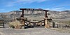 |
August 22, 1975 (#75000536) |
Address Restricted | Meeker | Site of the Battle of Milk Creek |
| 2 | Canon Pintado |  |
October 6, 1975 (#75000538) |
Address Restricted | Rangely | |
| 3 | Carrot Men Pictograph Site | 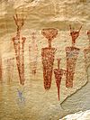 |
August 22, 1975 (#75000539) |
Address Restricted | Rangely | |
| 4 | Coal Creek School |  |
July 18, 2014 (#14000421) |
617 County Road 6 40°01′52″N 107°49′02″W / 40.0311°N 107.8172°W | Meeker | |
| 5 | Collage Shelter Site | 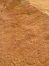 |
August 27, 1980 (#80000924) |
Address Restricted | Rangely | |
| 6 | Duck Creek Wickiup Village | November 20, 1975 (#75000537) |
Address Restricted | Meeker | ||
| 7 | Fremont Lookout Fortification Site |  |
November 20, 1974 (#74000593) |
Address Restricted | Rangely | |
| 8 | Hay's Ranch Bridge |  |
February 4, 1985 (#85000233) |
County Road 127 40°00′48″N 108°05′32″W / 40.013333°N 108.092222°W | Meeker | |
| 9 | Meeker Historic District |  |
January 28, 2019 (#100003359) |
Main, 4th, 5th, 6th, 7th & 8th Streets 40°02′15″N 107°54′47″W / 40.037482°N 107.913065°W | Meeker | |
| 10 | Hotel Meeker | 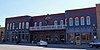 |
May 7, 1980 (#80000923) |
560 Main St. 40°02′14″N 107°54′45″W / 40.037222°N 107.9125°W | Meeker | |
| 11 | Meeker I.O.O.F. Lodge-Valentine Lodge No. 47 |  |
March 19, 2014 (#14000060) |
400 Main St. 40°02′15″N 107°54′40″W / 40.037616°N 107.911095°W | Meeker | |
| 12 | Pyramid Guard Station |  |
January 10, 2008 (#07001354) |
County Road 8 40°09′10″N 107°13′26″W / 40.152778°N 107.223889°W | Yampa | |
| 13 | St. James Episcopal Church |  |
March 30, 1978 (#78000883) |
368 4th St. 40°02′19″N 107°54′37″W / 40.038611°N 107.910278°W | Meeker |
Former listings edit
| [3] | Name on the Register | Image | Date listed | Date removed | Location | City or town | Description |
|---|---|---|---|---|---|---|---|
| 1 | Whiskey Creek Trestle |  |
April 22, 1980 (#80000925) | November 25, 1987 | West of Rangely | Rangely | Relocated to Cross Land and Fruit Company Orchards and Ranch Historic Site in Grand Junction, Colorado in 1987.[6] |
See also edit
References edit
- ^ The latitude and longitude information provided in this table was derived originally from the National Register Information System, which has been found to be fairly accurate for about 99% of listings. Some locations in this table may have been corrected to current GPS standards.
- ^ National Park Service, United States Department of the Interior, "National Register of Historic Places: Weekly List Actions", retrieved April 12, 2024.
- ^ a b Numbers represent an alphabetical ordering by significant words. Various colorings, defined here, differentiate National Historic Landmarks and historic districts from other NRHP buildings, structures, sites or objects.
- ^ "National Register Information System". National Register of Historic Places. National Park Service. July 9, 2010.
- ^ The eight-digit number below each date is the number assigned to each location in the National Register Information System database, which can be viewed by clicking the number.
- ^ "Colorado Office of Archaeology and Historic Preservation | Properties removed from the National and State Registers". Archived from the original on 2012-08-18. Retrieved 2012-08-17.
External links edit
Wikimedia Commons has media related to Rio Blanco County, Colorado.
- State of Colorado
- History Colorado
- Rio Blanco County, Colorado
39°58′51″N 108°13′04″W / 39.9807°N 108.2179°W