
KNOWPIA
WELCOME TO KNOWPIA

National Register of Historic Places listings in Saddle River, New Jersey 
Summary
List of the National Register of Historic Places listings in the borough of Saddle River in Bergen County, New Jersey

| Atlantic – Bergen (Closter, Franklin Lakes, Ridgewood, Saddle River, Wyckoff) – Burlington – Camden – Cape May – Cumberland – Essex – Gloucester – Hudson – Hunterdon – Mercer – Middlesex – Monmouth – Morris – Ocean – Passaic – Salem – Somerset – Sussex – Union – Warren |
The table below includes 23 sites listed on the National Register of Historic Places in the borough of Saddle River in Bergen County, New Jersey. Latitude and longitude coordinates of the sites listed on this page may be displayed in an online map.[1]
This National Park Service list is complete through NPS recent listings posted April 12, 2024.[2]
Current listings edit
| [3] | Name on the Register[4] | Image | Date listed[5] | Location | Description |
|---|---|---|---|---|---|
| 1 | Achenbach House | 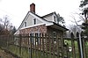 |
April 18, 1979 (#79001475) |
184 Chestnut Ridge Road 41°02′13″N 74°04′53″W / 41.036944°N 74.081389°W |
Part of the Early Stone Houses of Bergen County Multiple Property Submission MPS and the Saddle River MPS. Mostly destroyed by fire in 2004. |
| 2 | Ackerman House | 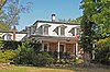 |
January 10, 1983 (#83001449) |
136 Chestnut Ridge Road 41°01′42″N 74°05′07″W / 41.028333°N 74.085278°W |
Part of the Early Stone Houses of Bergen County MPS and the Saddle River MPS |
| 3 | Abram Ackerman House |  |
January 10, 1983 (#83001447) |
199 E. Saddle River Road 41°02′11″N 74°05′59″W / 41.036389°N 74.099722°W |
Part of the Early Stone Houses of Bergen County MPS and the Saddle River MPS |
| 4 | Garret and Maria Ackerman House |  |
August 29, 1986 (#86001598) |
150 E. Saddle River Road 41°01′41″N 74°05′43″W / 41.028056°N 74.095278°W |
Part of the Saddle River MPS |
| 5 | Garret Augustus Ackerman House |  |
August 29, 1986 (#86001597) |
212 E. Saddle River Road 41°02′20″N 74°05′53″W / 41.038976°N 74.098020°W |
Part of the Saddle River MPS. Demolished. |
| 6 | Ackerman–Dater House | 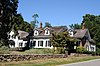 |
January 10, 1983 (#83001453) |
109 W. Saddle River Road 41°01′36″N 74°06′10″W / 41.026622°N 74.102892°W |
Part of the Early Stone Houses of Bergen County MPS and the Saddle River MPS |
| 7 | Ackerman–Dewsnap House | 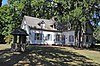 |
August 29, 1986 (#86001599) |
176 E. Saddle River Road 41°02′00″N 74°05′56″W / 41.033303°N 74.098967°W |
Part of the Saddle River MPS |
| 8 | Ackerman–Smith House |  |
August 29, 1986 (#86001600) |
171 E. Allendale Road 41°02′09″N 74°04′58″W / 41.035833°N 74.082778°W |
Part of the Saddle River MPS |
| 9 | J. J. Carlock House |  |
August 29, 1986 (#86001602) |
2 Chestnut Ridge Rd. 41°00′21″N 74°05′22″W / 41.005833°N 74.089444°W |
|
| 10 | Evangelical Lutheran Church of Saddle River and Ramapough Building | 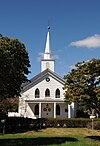 |
August 29, 1986 (#86001603) |
96 E. Allendale Rd. 41°01′52″N 74°05′49″W / 41.031111°N 74.096944°W |
|
| 11 | Alonzo Foringer House and Studio |  |
August 29, 1986 (#86001604) |
107 and 107B E. Saddle River Rd. 41°01′19″N 74°05′48″W / 41.021944°N 74.096667°W |
|
| 12 | Hopper House | 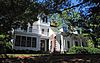 |
July 24, 1984 (#84002569) |
45 W. Saddle River Rd. 41°00′59″N 74°06′18″W / 41.016494°N 74.105014°W |
|
| 13 | Joe Jefferson Clubhouse |  |
August 29, 1986 (#86001605) |
29 E. Saddle River Rd. 41°00′40″N 74°05′45″W / 41.011111°N 74.095833°W |
|
| 14 | O'Blenis House | 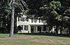 |
August 29, 1986 (#86001606) |
220 E. Saddle River Rd. 41°02′24″N 74°05′51″W / 41.039942°N 74.097625°W |
|
| 15 | Garret K. Osborn House and Barn |  |
August 29, 1986 (#86001607) |
88 and 90 E. Allendale Rd. 41°01′52″N 74°05′52″W / 41.031111°N 74.097778°W |
|
| 16 | Dr. E. G. Roy House | 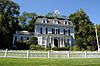 |
August 29, 1986 (#86001608) |
229 W. Saddle River Rd. 41°02′46″N 74°06′10″W / 41.046111°N 74.102778°W |
|
| 17 | Saddle River Center Historic District | 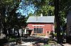 |
August 29, 1986 (#86001609) |
Along W. Saddle River Rd. at jct. of E. Allendale Rd. 41°01′53″N 74°06′10″W / 41.031389°N 74.102778°W |
|
| 18 | Stillwell–Preston House |  |
August 29, 1986 (#86001610) |
9 E. Saddle River Road 41°00′25″N 74°05′40″W / 41.006944°N 74.094444°W |
Part of the Saddle River MPS |
| 19 | Andries Thomas Van Buskirk House | 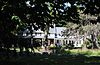 |
January 10, 1983 (#83001559) |
164 E. Saddle River Road 41°01′49″N 74°05′41″W / 41.030336°N 74.094594°W |
Part of the Early Stone Houses of Bergen County MPS and the Saddle River MPS |
| 20 | Laurance Thomas Van Buskirk House | 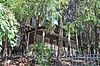 |
January 10, 1983 (#83001560) |
116 E. Saddle River Road 41°01′21″N 74°05′48″W / 41.022544°N 74.096672°W |
Part of the Early Stone Houses of Bergen County MPS and the Saddle River MPS |
| 21 | B. C. Wandell House |  |
August 29, 1986 (#86001612) |
214, 223, and 224 W. Saddle River Road 41°02′42″N 74°06′10″W / 41.045°N 74.102778°W |
Part of the Saddle River MPS. Also known as B. C. Wandell House–The Cedars |
| 22 | F. L. Wandell Estate and Ward Factory Site |  |
November 1, 1990 (#86001614) |
255-261 E. Saddle River Road 41°02′48″N 74°05′59″W / 41.046667°N 74.099722°W |
Part of the Saddle River MPS |
| 23 | Dr. John Christie Ware Bungalow | 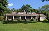 |
August 29, 1986 (#86001615) |
246 E. Saddle River Rd. 41°02′38″N 74°05′53″W / 41.044017°N 74.097953°W |
References edit
- ^ The latitude and longitude information provided in this table was derived originally from the National Register Information System, which has been found to be fairly accurate for about 99% of listings. Some locations in this table may have been corrected to current GPS standards.
- ^ National Park Service, United States Department of the Interior, "National Register of Historic Places: Weekly List Actions", retrieved April 12, 2024.
- ^ Numbers represent an alphabetical ordering by significant words. Various colorings, defined here, differentiate National Historic Landmarks and historic districts from other NRHP buildings, structures, sites or objects.
- ^ "National Register Information System". National Register of Historic Places. National Park Service. July 9, 2010.
- ^ The eight-digit number below each date is the number assigned to each location in the National Register Information System database, which can be viewed by clicking the number.