
KNOWPIA
WELCOME TO KNOWPIA

National Register of Historic Places listings in Saluda County, South Carolina 
Summary
This is a list of the National Register of Historic Places listings in Saluda County, South Carolina.

This is intended to be a complete list of the properties and districts on the National Register of Historic Places in Saluda County, South Carolina, United States. The locations of National Register properties and districts for which the latitude and longitude coordinates are included below, may be seen in a map.[1]
Eleven properties and districts are listed on the National Register in the county.
This National Park Service list is complete through NPS recent listings posted April 12, 2024.[2]
Current listings edit
| [3] | Name on the Register[4] | Image | Date listed[5] | Location | City or town | Description |
|---|---|---|---|---|---|---|
| 1 | Bonham House |  |
December 30, 1974 (#74001875) |
Southeast of Saluda off U.S. Route 178 34°00′29″N 81°41′53″W / 34.008056°N 81.698056°W | Saluda | |
| 2 | Butler Family Cemetery |  |
December 31, 1974 (#74001874) |
Northeast of Saluda off South Carolina Highway 194 34°03′56″N 81°43′33″W / 34.065556°N 81.725833°W | Saluda | |
| 3 | Marsh-Johnson House |  |
June 17, 1982 (#82003904) |
Intersection of S-41-21 and S-41-37 33°54′25″N 81°49′48″W / 33.906944°N 81.83°W | Saluda | |
| 4 | Old Strother Place |  |
February 25, 1994 (#94000063) |
Eastern side of Fruit Hill Rd., 0.3 miles north of the junction with Chappells Ferry Rd. 33°56′59″N 81°51′22″W / 33.949722°N 81.856111°W | Saluda | |
| 5 | Ridge Hill High School |  |
June 9, 2010 (#10000341) |
206 Ridge Hill Dr. 33°51′12″N 81°39′25″W / 33.853208°N 81.656814°W | Ridge Spring | |
| 6 | Saluda Old Town Site | June 28, 1972 (#72001223) |
Address Restricted | Saluda | ||
| 7 | Saluda Theatre | 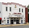 |
December 13, 1993 (#93001406) |
107 Law Range 34°00′04″N 81°46′16″W / 34.001111°N 81.771111°W | Saluda | |
| 8 | Spann Methodist Church and Cemetery |  |
October 18, 2003 (#03001059) |
150 Church St. 33°51′24″N 81°43′40″W / 33.856667°N 81.727778°W | Ward | |
| 9 | Stevens-Dorn Farmstead |  |
July 25, 1997 (#97000778) |
County Road 156, 0.5 miles south of its junction with U.S. Route 178 34°01′11″N 81°53′39″W / 34.019722°N 81.894167°W | Saluda | |
| 10 | Webb-Coleman House |  |
April 24, 1992 (#92000365) |
2 miles south of Chappells, 0.3 miles east of South Carolina Highway 39, at the junction of three dirt roads 34°08′54″N 81°50′37″W / 34.148333°N 81.843611°W | Chappells | |
| 11 | Whitehall |  |
August 21, 1980 (#80003697) |
Etheredge Rd. 33°59′34″N 81°46′08″W / 33.992778°N 81.768889°W | Saluda |
See also edit
Wikimedia Commons has media related to National Register of Historic Places in Saluda County, South Carolina.
References edit
- ^ The latitude and longitude information provided in this table was derived originally from the National Register Information System, which has been found to be fairly accurate for about 99% of listings. Some locations in this table may have been corrected to current GPS standards.
- ^ National Park Service, United States Department of the Interior, "National Register of Historic Places: Weekly List Actions", retrieved April 12, 2024.
- ^ Numbers represent an alphabetical ordering by significant words. Various colorings, defined here, differentiate National Historic Landmarks and historic districts from other NRHP buildings, structures, sites or objects.
- ^ "National Register Information System". National Register of Historic Places. National Park Service. March 13, 2009.
- ^ The eight-digit number below each date is the number assigned to each location in the National Register Information System database, which can be viewed by clicking the number.