
KNOWPIA
WELCOME TO KNOWPIA

National Register of Historic Places listings in Sequoyah County, Oklahoma 
Summary
This is a list of the National Register of Historic Places listings in Sequoyah County, Oklahoma.

This is intended to be a complete list of the properties on the National Register of Historic Places in Sequoyah County, Oklahoma, United States. The locations of National Register properties for which the latitude and longitude coordinates are included below, may be seen in a map.[1]
There are 14 properties listed on the National Register in the county, including 1 National Historic Landmark.
This National Park Service list is complete through NPS recent listings posted April 12, 2024.[2]
Current listings edit
| [3] | Name on the Register[4] | Image | Date listed[5] | Location | City or town | Description |
|---|---|---|---|---|---|---|
| 1 | Baker "A" Archeological Site (34SQ269) | March 2, 1990 (#90000125) |
Address Restricted | Short | ||
| 2 | Citizen's State Bank | 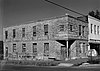 |
September 8, 1980 (#80003300) |
Seminole and Main Sts. 35°34′49″N 94°49′55″W / 35.580278°N 94.831944°W | Marble City | |
| 3 | Dwight Mission |  |
March 20, 1973 (#73001570) |
3 miles southwest of Marble City 35°32′51″N 94°51′09″W / 35.5475°N 94.8525°W | Marble City | |
| 4 | Ellison No. 2 Site (34SQ85) | August 11, 1988 (#88001234) |
Address Restricted | Short | ||
| 5 | Judge Franklin Faulkner House |  |
March 13, 1980 (#80003301) |
E. Cherokee St. 35°27′40″N 94°46′30″W / 35.461111°N 94.775°W | Sallisaw | |
| 6 | Fears Site (34SQ76) | August 11, 1988 (#88001235) |
Address Restricted | Nicut | ||
| 7 | First Presbyterian Church |  |
March 7, 2003 (#03000096) |
120 S. Oak St. 35°27′27″N 94°47′17″W / 35.4575°N 94.788056°W | Sallisaw | |
| 8 | Hines Round Barn |  |
March 8, 1984 (#84003432) |
401 S. Adams St. 35°26′55″N 94°47′17″W / 35.448611°N 94.788056°W | Sallisaw | |
| 9 | Kirby-Steely Archeological Site | April 3, 1991 (#91000356) |
Address Restricted | Short | ||
| 10 | Lee's Creek Ceremonial Site | January 31, 1976 (#76001575) |
Address Restricted | Short | ||
| 11 | Sallisaw High School |  |
July 3, 1997 (#97000614) |
200 W. Creek St. 35°27′25″N 94°47′29″W / 35.456944°N 94.791389°W | Sallisaw | Only outer walls of main entrance remained after fire. The site was demolished in February 2015. |
| 12 | Sequoyah's Cabin | 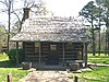 |
October 15, 1966 (#66000634) |
State Highway 101, in Sequoyah's Cabin State Park 35°30′47″N 94°39′07″W / 35.513056°N 94.651944°W | Akins | |
| 13 | Starr Pasture Archeological Site (34SQ224) | March 2, 1990 (#90000126) |
Address Restricted | Short | ||
| 14 | Tall Cane Archeological Site (34SQ294) | March 2, 1990 (#90000127) |
Address Restricted | Short |
See also edit
Wikimedia Commons has media related to National Register of Historic Places in Sequoyah County, Oklahoma.
References edit
- ^ The latitude and longitude information provided in this table was derived originally from the National Register Information System, which has been found to be fairly accurate for about 99% of listings. Some locations in this table may have been corrected to current GPS standards.
- ^ National Park Service, United States Department of the Interior, "National Register of Historic Places: Weekly List Actions", retrieved April 12, 2024.
- ^ Numbers represent an alphabetical ordering by significant words. Various colorings, defined here, differentiate National Historic Landmarks and historic districts from other NRHP buildings, structures, sites or objects.
- ^ "National Register Information System". National Register of Historic Places. National Park Service. March 13, 2009.
- ^ The eight-digit number below each date is the number assigned to each location in the National Register Information System database, which can be viewed by clicking the number.