
KNOWPIA
WELCOME TO KNOWPIA

National Register of Historic Places listings in Solano County, California 
Summary
This is a list of the National Register of Historic Places listings in Solano County, California.

This is intended to be a complete list of the properties and districts on the National Register of Historic Places in Solano County, California, United States. Latitude and longitude coordinates are provided for many National Register properties and districts; these locations may be seen together in an online map.[1]
There are 32 properties and districts listed on the National Register in the county, including 1 National Historic Landmark.
This National Park Service list is complete through NPS recent listings posted April 12, 2024.[2]
Current listings edit
| [3] | Name on the Register[4] | Image | Date listed[5] | Location | City or town | Description |
|---|---|---|---|---|---|---|
| 1 | Benicia Arsenal |  |
November 7, 1976 (#76000534) |
Army Point and I-680 38°03′12″N 122°08′03″W / 38.0534°N 122.1342°W | Benicia | |
| 2 | Benicia Capitol State Historic Park |  |
February 12, 1971 (#71000204) |
1st and G Sts. 38°03′00″N 122°09′32″W / 38.0501°N 122.1588°W | Benicia | |
| 3 | Benicia City Cemetery |  |
February 1, 2021 (#100006087) |
Bounded by Riverhill Dr., Riverview Terr., Shirley Dr., and Incline Pl. 38°03′28″N 122°09′10″W / 38.0579°N 122.1527°W | Benicia | |
| 4 | Benicia Southern Pacific Railroad Passenger Depot | 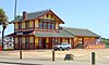 |
September 28, 2017 (#100001664) |
90 1st St. 38°02′41″N 122°09′44″W / 38.0446°N 122.1623°W | Benicia | |
| 5 | Bird and Dinkelspiel Store |  |
October 21, 1999 (#99001264) |
2145 Collinsville Rd. 38°07′58″N 121°52′16″W / 38.1328°N 121.8712°W | Birds Landing | General store built in 1875. |
| 6 | Jackson Fay Brown House |  |
November 7, 2002 (#02001289) |
6751 Maine Prairie Rd. 38°19′59″N 121°48′50″W / 38.333056°N 121.813889°W | Dixon | |
| 7 | Will H. Buck House | 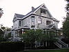 |
October 24, 1985 (#85003372) |
301 Buck Ave. 38°21′23″N 121°59′42″W / 38.356512°N 121.995096°W | Vacaville | |
| 8 | Carr House |  |
September 13, 1979 (#79000555) |
165 E. D St 38°02′48″N 122°09′32″W / 38.04679°N 122.158872°W | Benicia | demolished circa 2000[6] |
| 9 | Vallejo City Hall | 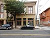 |
August 13, 2013 (#13000591) |
715 Marin St. 38°06′09″N 122°15′25″W / 38.102574°N 122.256807°W | Vallejo | |
| 10 | Crooks Mansion | 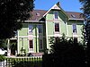 |
November 14, 1978 (#78000795) |
285 W. G St. 38°03′06″N 122°09′44″W / 38.051798°N 122.162173°W | Benicia | |
| 11 | Dixon Carnegie Library | 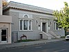 |
February 4, 2011 (#10001199) |
135 E. B St. 38°26′48″N 121°49′20″W / 38.446667°N 121.822222°W | Dixon | California Carnegie Libraries MPS |
| 12 | Joseph Fischer House |  |
May 24, 1979 (#79000556) |
135 G St. 38°03′01″N 122°09′34″W / 38.050262°N 122.159345°W | Benicia | |
| 13 | Daniel Webster Harrier House | 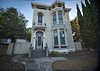 |
December 8, 2015 (#15000860) |
739 Ohio St. 38°06′25″N 122°15′13″W / 38.1070°N 122.253585°W | Vallejo | |
| 14 | Hastings Adobe |  |
June 13, 1972 (#72000260) |
Northeast of Collinsville off CA 68 38°04′35″N 121°49′54″W / 38.076516°N 121.83174°W | Collinsville | |
| 15 | LCS-102 (landing craft support) | 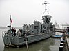 |
October 13, 2015 (#15000716) |
7th & Nimitz Sts., Mare Island 38°06′05″N 122°16′11″W / 38.1015°N 122.2698°W | Vallejo | |
| 16 | Mare Island Naval Shipyard | 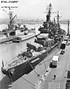 |
May 15, 1975 (#75002103) |
Mare Island 38°05′24″N 122°15′48″W / 38.09°N 122.263333°W | Vallejo | Boundary increase (added January 21, 1997): Mare Island Historic District, Vallejo, California |
| 17 | Samuel Martin House |  |
May 26, 1977 (#77000349) |
293 Suisun Valley Rd. 38°14′08″N 122°07′35″W / 38.235686°N 122.126418°W | Fairfield | 1861 home of early Solano County settler; also known as Stonedene |
| 18 | Masonic Temple-Naval Lodge No. 87, Free and Accepted Masons | 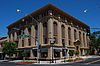 |
August 7, 2013 (#13000575) |
707 Marin St. 38°06′08″N 122°15′25″W / 38.102351°N 122.256817°W | Vallejo | |
| 19 | Old Masonic Hall | 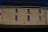 |
March 16, 1972 (#72000259) |
106 W. J St. 38°03′08″N 122°09′27″W / 38.052357°N 122.157423°W | Benicia | |
| 20 | Pena Adobe | 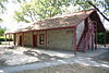 |
January 7, 1972 (#72000261) |
2 miles (3.2 km) southwest of Vacaville on I-80 38°20′11″N 122°00′54″W / 38.336262°N 122.014992°W | Vacaville | |
| 21 | Pleasants Ranch | April 7, 2006 (#06000280) |
8212 Pleasants Valley Rd. 38°27′50″N 122°03′00″W / 38.463813°N 122.049868°W | Vacaville | ||
| 22 | Sacramento Northern Railway Historic District | 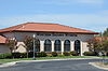 |
July 11, 2012 (#12000402) |
5848 State Highway 12 38°12′14″N 121°52′31″W / 38.20395°N 121.875384°W | Suisun City | Does this include the Western Railway Museum? |
| 23 | Saint Vincent's Hill Historic District | 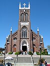 |
November 21, 2003 (#03001168) |
Roughly bounded by Mare Island Way almost to Sonoma Blvd. and from Quincy Alley to Kissel Alley 38°06′20″N 122°15′30″W / 38.105556°N 122.258333°W | Vallejo | |
| 24 | STAMBOUL (Whaling Bark) |  |
November 2, 1988 (#88002030) |
Foot of W. 12th St. 38°03′44″N 122°10′47″W / 38.062149°N 122.179606°W | Benicia | |
| 25 | Suisun Masonic Lodge No. 55 |  |
December 18, 1978 (#78000798) |
623 Main St. 38°14′19″N 122°02′27″W / 38.238601°N 122.040705°W | Suisun City | |
| 26 | USCGC STORIS (cutter) | 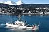 |
December 31, 2012 (#12001110) |
U.S. Maritime Administration National Defense Reserve Fleet, Suisun Bay 38°05′05″N 122°05′04″W / 38.084594°N 122.084322°W | Benicia | |
| 27 | Vacaville Town Hall |  |
September 18, 1978 (#78000799) |
620 E. Main St. 38°21′23″N 121°59′09″W / 38.356356°N 121.985881°W | Vacaville | |
| 28 | Vallejo City Hall and County Building Branch | 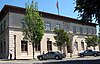 |
November 7, 1976 (#76000535) |
734 Marin St. 38°06′10″N 122°15′23″W / 38.102811°N 122.256451°W | Vallejo | |
| 29 | Vallejo Old City Historic District |  |
March 20, 1973 (#73000460) |
Sonoma Blvd., and Monterey, Carolina, and York Sts. 38°06′07″N 122°14′59″W / 38.101944°N 122.249722°W | Vallejo | |
| 30 | Von Pfister General Store |  |
June 24, 2015 (#15000360) |
Von Pfister Alley (waterfront between C and D Streets) 38°02′50″N 122°09′41″W / 38.047159°N 122.161309°W | Benicia | |
| 31 | Wednesday Club of Suisun |  |
December 29, 2022 (#100007819) |
225 Sacramento St. 38°14′21″N 122°02′33″W / 38.2391°N 122.0425°W | Suisun City | |
| 32 | Westminster Presbyterian Church and Cemetery of Tremont |  |
March 26, 2018 (#100002240) |
8290 Tremont Rd. 38°29′42″N 121°42′16″W / 38.495000°N 121.704391°W | Dixon |
See also edit
Wikimedia Commons has media related to National Register of Historic Places in Solano County, California.
References edit
- ^ The latitude and longitude information provided in this table was derived originally from the National Register Information System, which has been found to be fairly accurate for about 99% of listings. Some locations in this table may have been corrected to current GPS standards.
- ^ National Park Service, United States Department of the Interior, "National Register of Historic Places: Weekly List Actions", retrieved April 12, 2024.
- ^ Numbers represent an alphabetical ordering by significant words. Various colorings, defined here, differentiate National Historic Landmarks and historic districts from other NRHP buildings, structures, sites or objects.
- ^ "National Register Information System". National Register of Historic Places. National Park Service. July 9, 2010.
- ^ The eight-digit number below each date is the number assigned to each location in the National Register Information System database, which can be viewed by clicking the number.
- ^ See State of California Department of Parks and Recreation record