


Summary
This is a list of the National Register of Historic Places listings in Spencer County, Indiana.
This is intended to be a complete list of the properties and districts on the National Register of Historic Places in Spencer County, Indiana, United States. Latitude and longitude coordinates are provided for many National Register properties and districts; these locations may be seen together in a map.[1]
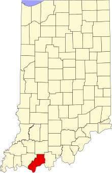
There are 9 properties and districts listed on the National Register in the county, including 1 National Historic Landmark. Another 2 properties were once listed but have been removed.
Properties and districts located in incorporated areas display the name of the municipality, while properties and districts in unincorporated areas display the name of their civil township. Properties and districts split between multiple jurisdictions display the names of all jurisdictions.
This National Park Service list is complete through NPS recent listings posted April 5, 2024.[2]
Current listings edit
| [3] | Name on the Register[4] | Image | Date listed[5] | Location | City or town | Description |
|---|---|---|---|---|---|---|
| 1 | Hardy-Baumgaertner House | November 29, 2019 (#100004718) |
105 Walnut St. 37°52′56″N 87°02′44″W / 37.8821°N 87.0455°W | Rockport | ||
| 2 | Huffman Mill Covered Bridge |  |
April 1, 1998 (#98000299) |
CR 1490N over the Anderson River, east of Fulda 38°06′14″N 86°46′37″W / 38.103889°N 86.776944°W | Harrison Township | Extends into Perry County |
| 3 | Colonel William Jones House | 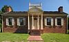 |
May 12, 1975 (#75000050) |
West of Gentryville on Troy-Vincennes Rd. 38°06′51″N 87°02′34″W / 38.114115°N 87.04291°W | Jackson Township | Part of Lincoln State Park |
| 4 | Lincoln Boyhood National Memorial |  |
October 15, 1966 (#66000012) |
State Road 162, southeast of Lincoln City 38°07′06″N 86°59′49″W / 38.118333°N 86.996944°W | Carter and Clay Townships | |
| 5 | Lincoln Pioneer Village |  |
April 20, 1998 (#98000305) |
Junction of 9th St. and Eureka Rd. 37°52′48″N 87°03′28″W / 37.880000°N 87.057778°W | Rockport | |
| 6 | Rockport Historic District |  |
August 28, 2019 (#100004359) |
Roughly bounded by First St., Seminary St., a line from north to south following Greenwood St., Lincoln Ave. and Eighth St., and William and Pearl Sts., 37°53′00″N 87°02′58″W / 37.8832°N 87.0495°W | Rockport | |
| 7 | St. Boniface Church |  |
October 23, 1980 (#80000065) |
State Road 545 at Fulda 38°06′41″N 86°50′08″W / 38.111389°N 86.835556°W | Harrison Township | |
| 8 | Mathias Sharp House | 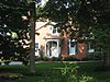 |
June 16, 1983 (#83000148) |
319 S. 2nd St. 37°52′48″N 87°02′40″W / 37.88°N 87.044444°W | Rockport | |
| 9 | Spencer County Courthouse |  |
March 12, 1999 (#99000304) |
Bounded by 2nd, 3rd, Main, and Walnut Sts. 37°52′57″N 87°02′47″W / 37.8825°N 87.046389°W | Rockport |
Former listings edit
| [3] | Name on the Register | Image | Date listed | Date removed | Location | City or town | Description |
|---|---|---|---|---|---|---|---|
| 1 | Brown-Kercheval House | September 20, 1973 (#73000045) | April 28, 1994 | 315 S. 2nd St. | Rockport | Destroyed by fire in April 1994. | |
| 2 | Deutsch Evangelische St. Paul's Kirche |  |
September 27, 1984 (#84001644) | November 13, 2012 | South of central Santa Claus on Santa Fe Rd. 38°06′40″N 86°54′33″W / 38.111111°N 86.909167°W | Santa Claus | Moved to Santa Claus Park in 2012[6] |
See also edit
References edit
- ^ The latitude and longitude information provided in this table was derived originally from the National Register Information System, which has been found to be fairly accurate for about 99% of listings. Some locations in this table may have been corrected to current GPS standards.
- ^ National Park Service, United States Department of the Interior, "National Register of Historic Places: Weekly List Actions", retrieved April 5, 2024.
- ^ a b Numbers represent an alphabetical ordering by significant words. Various colorings, defined here, differentiate National Historic Landmarks and historic districts from other NRHP buildings, structures, sites or objects.
- ^ "National Register Information System". National Register of Historic Places. National Park Service. March 13, 2009.
- ^ The eight-digit number below each date is the number assigned to each location in the National Register Information System database, which can be viewed by clicking the number.
- ^ Historic church relocated to Santa Claus Park, Evansville Courier & Press, 2012-02-08. Accessed 2012-10-12.