
KNOWPIA
WELCOME TO KNOWPIA

National Register of Historic Places listings in St. Charles Parish, Louisiana 
Summary
This is a list of the National Register of Historic Places listings in St. Charles Parish, Louisiana.

This is intended to be a complete list of the properties and districts on the National Register of Historic Places in St. Charles Parish, Louisiana, United States. The locations of National Register properties and districts for which the latitude and longitude coordinates are included below, may be seen in a map.[1]
There are 7 properties and districts listed on the National Register in the parish, including 1 National Historic Landmark.
This National Park Service list is complete through NPS recent listings posted April 5, 2024.[2]
Current listings edit
| [3] | Name on the Register | Image | Date listed[4] | Location | City or town | Description |
|---|---|---|---|---|---|---|
| 1 | Destrehan Plantation |  |
March 20, 1973 (#73002132) |
River Rd. (Louisiana Highway 48) 29°56′43″N 90°21′55″W / 29.945278°N 90.365278°W | Destrehan | Completed in 1790, the site of one of three tribunals which tried and executed slaves after the 1811 German Coast Uprising, the largest slave rebellion in U.S. history; this occurred during the Orleans Territorial period, about eighteen months before Louisiana statehood. The house and grounds have been restored by a nonprofit organization and are open to the public. |
| 2 | Dorvin House |  |
May 24, 1990 (#90000799) |
Louisiana Highway 18 northwest of Hahnville 29°59′18″N 90°25′15″W / 29.988333°N 90.420833°W | Hahnville | |
| 3 | Homeplace Plantation House |  |
April 15, 1970 (#70000842) |
Louisiana Highway 18, 0.5 miles south of Hahnville 29°58′12″N 90°24′32″W / 29.97°N 90.408889°W | Hahnville | Built circa 1790, large French Colonial raised cottage. Not open to the public. |
| 4 | Kenner and Kugler Cemeteries Archeological District | October 16, 1987 (#87001762) |
Address Restricted | Norco | ||
| 5 | LaBranche Plantation Dependency |  |
October 18, 1984 (#84000145) |
River Rd. (Louisiana Highway 48) 29°57′00″N 90°18′58″W / 29.95°N 90.316111°W | St. Rose | |
| 6 | Odd Fellows Hall | December 5, 2019 (#100004730) |
224 Shaw St. 29°58′32″N 90°24′35″W / 29.9756°N 90.4098°W | Hahnville | ||
| 7 | Ormond Plantation House | 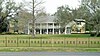 |
November 8, 1990 (#90001748) |
River Rd. (Louisiana Highway 48) 29°57′15″N 90°23′13″W / 29.954167°N 90.386944°W | Destrehan |
See also edit
References edit
- ^ The latitude and longitude information provided in this table was derived originally from the National Register Information System, which has been found to be fairly accurate for about 99% of listings. Some locations in this table may have been corrected to current GPS standards.
- ^ National Park Service, United States Department of the Interior, "National Register of Historic Places: Weekly List Actions", retrieved April 5, 2024.
- ^ Numbers represent an alphabetical ordering by significant words. Various colorings, defined here, differentiate National Historic Landmarks and historic districts from other NRHP buildings, structures, sites or objects.
- ^ The eight-digit number below each date is the number assigned to each location in the National Register Information System database, which can be viewed by clicking the number.