


Summary
This is a list of National Register of Historic Places listings in Starr County, Texas.

This is intended to be a complete list of properties and districts listed on the National Register of Historic Places in Starr County, Texas. There are three districts, including one National Historic Landmark (NHL) district, and six individual properties listed on the National Register in the county. All of the districts contain several Recorded Texas Historic Landmarks while the NHL district also holds State Antiquities Landmarks including one that is individually listed on the National Register.
This National Park Service list is complete through NPS recent listings posted April 5, 2024.[1]
Current listings edit
The locations of National Register properties and districts may be seen in a mapping service provided.[2]
| [3] | Name on the Register | Image | Date listed[4] | Location | City or town | Description |
|---|---|---|---|---|---|---|
| 1 | Silverio de la Pena Drugstore and Post Office | 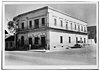 |
September 2, 1980 (#80004150) |
423 E. Main St. 26°22′39″N 98°49′00″W / 26.3775°N 98.816667°W | Rio Grande City | Part of Rio Grande City Downtown Historic District |
| 2 | Fort Ringgold Historic District |  |
March 26, 1993 (#93000196) |
Rio Grande City School grounds, 1/4 mi. SE of jct. of US 83 and TX 755 26°22′25″N 98°48′26″W / 26.373611°N 98.807222°W | Rio Grande City | Includes Recorded Texas Historic Landmarks |
| 3 | Fred and Nell Kain Guerra House | December 6, 2005 (#05001400) |
800 Blk. W Main 26°22′54″N 98°49′45″W / 26.381667°N 98.829167°W | Rio Grande City | ||
| 4 | LaBorde House, Store and Hotel |  |
May 29, 1980 (#80004149) |
601 E. Main St. 26°22′38″N 98°48′56″W / 26.377222°N 98.81554°W | Rio Grande City | Part of Rio Grande City Downtown Historic District |
| 5 | Mifflin Kenedy Warehouse and Old Starr County Courthouse | 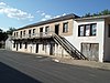 |
July 8, 2005 (#05000657) |
200 Blk. W. Water St. 26°22′49″N 98°49′21″W / 26.380278°N 98.8225°W | Rio Grande City | |
| 6 | Rio Grande City Downtown Historic District |  |
July 8, 2005 (#05000656) |
Roughly bounded by N. Corpus, E. Wimpy, N. Avasolo and E. Mirasoles 26°22′41″N 98°49′01″W / 26.37817°N 98.8169°W | Rio Grande City | Includes Recorded Texas Historic Landmarks |
| 7 | Roma Historic District |  |
July 31, 1972 (#72001371) |
Properties along Estrella and Hidalgo Sts. between Garfield St. and Bravo Alley 26°24′22″N 99°01′05″W / 26.406111°N 99.018056°W | Roma | Includes State Antiquities Landmarks, Recorded Texas Historic Landmarks |
| 8 | Roma-San Pedro International Bridge | March 23, 1984 (#84001959) |
SW of Hidalgo St. and Bravo Alley 26°24′13″N 99°01′06″W / 26.403611°N 99.018333°W | Roma-Los Saenz | Part of Roma Historic District; State Antiquities Landmark | |
| 9 | Yzaquirre-Longoria House | December 22, 2005 (#05001462) |
107 W. Water St. 26°22′44″N 98°49′23″W / 26.37902°N 98.82317°W | Rio Grande City |
See also edit
References edit
- ^ National Park Service, United States Department of the Interior, "National Register of Historic Places: Weekly List Actions", retrieved April 5, 2024.
- ^ The latitude and longitude information provided in this table was derived originally from the National Register Information System, which has been found to be fairly accurate for about 99% of listings. Some locations in this table may have been corrected to current GPS standards.
- ^ Numbers represent an alphabetical ordering by significant words. Various colorings, defined here, differentiate National Historic Landmarks and historic districts from other NRHP buildings, structures, sites or objects.
- ^ The eight-digit number below each date is the number assigned to each location in the National Register Information System database, which can be viewed by clicking the number.
External links edit
![]() Media related to National Register of Historic Places in Starr County, Texas at Wikimedia Commons
Media related to National Register of Historic Places in Starr County, Texas at Wikimedia Commons