
KNOWPIA
WELCOME TO KNOWPIA

National Register of Historic Places listings in Suffolk, Virginia 
Summary
This is a list of the National Register of Historic Places listings in Suffolk, Virginia.
This is intended to be a complete list of the properties and districts on the National Register of Historic Places in the independent city of Suffolk, Virginia, United States. The locations of National Register properties and districts for which the latitude and longitude coordinates are included below, may be seen in an online map.[1]
There are 26 properties and districts listed on the National Register in the city.
This National Park Service list is complete through NPS recent listings posted April 5, 2024.[2]
Current listings edit
| [3] | Name on the Register[4] | Image | Date listed[5] | Location | Description |
|---|---|---|---|---|---|
| 1 | Bay Point Farm | 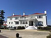 |
June 23, 2003 (#03000571) |
1400 Sleepy Hole Rd. 36°50′38″N 76°31′03″W / 36.843889°N 76.517500°W |
|
| 2 | Building at 216 Bank Street | 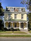 |
November 7, 1985 (#85002765) |
216 Bank St. 36°43′45″N 76°34′47″W / 36.729167°N 76.579722°W |
|
| 3 | Cedar Hill Cemetery |  |
February 1, 2006 (#05001584) |
South of E. Constance Rd. 36°44′15″N 76°34′47″W / 36.7375°N 76.579722°W |
|
| 4 | Chuckatuck Historic District |  |
April 7, 1995 (#95000393) |
Junction of State Routes 10/32 with State Route 125 36°51′40″N 76°34′45″W / 36.861111°N 76.579167°W |
Current settlement dates from 1635 land grant to Richard Bartlett, who built a grist mill at the head of Chuckatuck Creek that operated until 1970. Quaker leader George Fox founded Chuckatuck Meeting in 1672.[6] |
| 5 | Driver Historic District |  |
April 7, 1995 (#95000394) |
Junction of State Route 125 and Driver Lane 36°49′23″N 76°30′13″W / 36.823056°N 76.503611°W |
|
| 6 | Dumpling Island Archeological Site |  |
February 10, 1998 (#98000046) |
Eastern side of the Nansemond River[7] 36°48′36″N 76°33′18″W / 36.810000°N 76.555000°W |
|
| 7 | East Suffolk Complex | 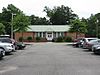 |
August 4, 2003 (#03000743) |
231 S. 7th St. 36°43′30″N 76°33′52″W / 36.725000°N 76.564444°W |
|
| 8 | Samuel Eley House |  |
August 9, 2019 (#100004261) |
4801 Pruden Boulevard 36°47′21″N 76°39′36″W / 36.789167°N 76.660000°W |
|
| 9 | Freeman House | 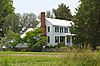 |
September 23, 1982 (#82003454) |
North of Gates, North Carolina, on U.S. Route 13 36°33′03″N 76°45′20″W / 36.550833°N 76.755472°W |
Extends into Gates County, North Carolina |
| 10 | Glebe Church |  |
May 25, 1973 (#73002148) |
West of Chesapeake City on State Route 337 36°49′29″N 76°29′48″W / 36.824722°N 76.496667°W |
|
| 11 | Godwin-Knight House |  |
August 24, 1992 (#92001028) |
140 King's Highway 36°51′42″N 76°34′41″W / 36.861667°N 76.577917°W |
C.B Godwin home built in 1780 and lived in by Ray and Mildred Knight, sister of Mills E. Godwin, Jr.[6] |
| 12 | Joel E. Harrell and Son |  |
February 1, 2006 (#05001580) |
110 Virginia Ham Dr. 36°44′32″N 76°33′30″W / 36.742222°N 76.558333°W |
|
| 13 | Holland Historic District |  |
May 18, 1995 (#95000600) |
Junction of U.S. Route 58 with State Route 189 and Dutch Rd. 36°40′53″N 76°46′48″W / 36.681389°N 76.780000°W |
|
| 14 | Knotts Creek-Belleville Archeological Site |  |
June 10, 2008 (#08000524) |
0.2 miles west of the intersection of U.S. Route 17 and Town Point Rd.[8] 36°51′53″N 76°26′27″W / 36.864722°N 76.440833°W |
|
| 15 | Mount Sinai Baptist Church |  |
March 20, 2007 (#07000193) |
6100 Holy Neck Rd. 36°38′14″N 76°49′46″W / 36.637222°N 76.829444°W |
|
| 16 | Nansemond County Training School |  |
August 11, 2004 (#04000847) |
9307 Southwestern Boulevard 36°38′15″N 76°48′15″W / 36.637500°N 76.804167°W |
|
| 17 | Phillips Farm | 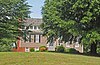 |
October 30, 1998 (#98001318) |
6353 Godwin Boulevard 36°52′33″N 76°35′02″W / 36.875972°N 76.583889°W |
|
| 18 | Phoenix Bank of Nansemond |  |
January 24, 1991 (#90002159) |
339 E. Washington St. 36°43′36″N 76°34′42″W / 36.726667°N 76.578472°W |
|
| 19 | Professional Building |  |
August 12, 1999 (#99001005) |
100 N. Main St. 36°43′42″N 76°34′59″W / 36.728333°N 76.583056°W |
|
| 20 | Riddick House | 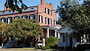 |
May 2, 1974 (#74002247) |
510 Main St. 36°44′14″N 76°34′56″W / 36.737222°N 76.582222°W |
|
| 21 | St. John's Church |  |
April 11, 1973 (#73002149) |
East of Chuckatuck on State Route 125 36°51′26″N 76°33′40″W / 36.857222°N 76.561111°W |
Oldest church in Chuckatuck, est. 1642, present building completed 1756, external dimensions 60 x 30 feet, walls 21 inches thick. Date 1753 appears on south wall along with the initials A.H. and E.H. for Anthony Holladay and his wife Esther, who deeded the site to the parish.[9] |
| 22 | Somerton Historic District |  |
December 31, 2008 (#08001272) |
Arthur Dr., Pittmantown Rd., and Boonetown Rd. 36°34′06″N 76°45′03″W / 36.568333°N 76.750833°W |
|
| 23 | Suffolk Historic District |  |
June 22, 1987 (#87000631) |
Roughly bounded by railroad tracks, Hill St., Central Ave., and Holladay, Washington, N. Saratoga, and Pine Sts.; also roughly along N. Main St. from Constance Rd. to the Norfolk Southern railroad tracks; also roughly bounded by the Norfolk Southern railroad tracks, County St., Liberty St., Bank St., Market St., Clay St., and Poplar St.; also Pinner and Central Aves. and W. Washington St. 36°43′47″N 76°34′56″W / 36.729722°N 76.582222°W |
Second, third, and fourth sets of boundaries represent boundary increases of June 10, 1999, September 14, 2002, and December 3, 2004 |
| 24 | The Suffolk Peanut Company |  |
November 22, 2016 (#16000801) |
303 S. Saratoga St. 36°43′30″N 76°35′20″W / 36.725000°N 76.588889°W |
|
| 25 | West End Historic District |  |
January 16, 2004 (#03001433) |
Roughly bounded by Causey Ave., the Seaboard Coast Line railroad tracks, Pender St., Wellons St., Linden Ave., and other railroad tracks; also roughly bounded by Wellons, Washington, and Smith Sts. 36°43′44″N 76°35′33″W / 36.728889°N 76.592500°W |
Second set of boundaries represents a boundary increase of November 27, 2004 |
| 26 | Whaleyville Historic District |  |
April 7, 1995 (#95000392) |
Junction of U.S. Route 13 and Mineral Spring Rd. 36°35′21″N 76°41′03″W / 36.589167°N 76.684167°W |
See also edit
Wikimedia Commons has media related to National Register of Historic Places in Suffolk, Virginia.
References edit
- ^ The latitude and longitude information provided in this table was derived originally from the National Register Information System, which has been found to be fairly accurate for about 99% of listings. Some locations in this table may have been corrected to current GPS standards.
- ^ National Park Service, United States Department of the Interior, "National Register of Historic Places: Weekly List Actions", retrieved April 5, 2024.
- ^ Numbers represent an alphabetical ordering by significant words. Various colorings, defined here, differentiate National Historic Landmarks and historic districts from other NRHP buildings, structures, sites or objects.
- ^ "National Register Information System". National Register of Historic Places. National Park Service. April 24, 2008.
- ^ The eight-digit number below each date is the number assigned to each location in the National Register Information System database, which can be viewed by clicking the number.
- ^ a b Bradshaw, Drexel. "The Village of Chuckatuck in Text". Greater Chuckatuck Historical Foundation. Archived from the original on 28 June 2013. Retrieved 26 April 2013.
- ^ "Dumpling Island". Geographic Names Information System. United States Geological Survey, United States Department of the Interior.
- ^ Turner, E. Randolph, III. National Register of Historic Places Registration Form: Knotts Creek/Belleville Archaeological Site. National Park Service. May 5, 2007.
- ^ "Chuckatuck Churches". Greater Chuckatuck Historical Foundation. Archived from the original on 2 May 2012. Retrieved 26 April 2013.