
KNOWPIA
WELCOME TO KNOWPIA

National Register of Historic Places listings in Thurston County, Washington 
Summary
This is a list of the National Register of Historic Places listings in Thurston County, Washington.

This is intended to be a complete list of the properties and districts on the National Register of Historic Places in Thurston County, Washington, United States. Latitude and longitude coordinates are provided for many National Register properties and districts; these locations may be seen together in an online map.[1]
There are 66 properties and districts listed on the National Register in the county.
This National Park Service list is complete through NPS recent listings posted April 12, 2024.[2]
Current listings edit
| [3] | Name on the Register | Image | Date listed[4] | Location | City or town | Description |
|---|---|---|---|---|---|---|
| 1 | Allen House Hotel |  |
June 17, 1987 (#87000872) |
114-118 N. Jefferson 47°02′46″N 122°53′43″W / 47.046111°N 122.895278°W | Olympia | Built in 1891, the building is now known as the Jefferson Apartments. |
| 2 | American Legion Hall |  |
June 17, 1987 (#87000871) |
219 W. Legion Way 47°02′35″N 122°54′08″W / 47.043056°N 122.902222°W | Olympia | |
| 3 | Daniel R. Bigelow House | 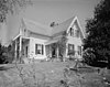 |
August 7, 1979 (#79002562) |
918 Glass St 47°03′00″N 122°53′23″W / 47.05°N 122.889722°W | Olympia | Built in 1854. |
| 4 | Black Lake School |  |
May 10, 1990 (#90000709) |
6000 Black Lake Blvd. SW. 46°59′39″N 122°59′12″W / 46.994167°N 122.986667°W | Olympia | |
| 5 | Capital Boulevard Crossing |  |
July 16, 1982 (#82004300) |
Spans Deschutes River 47°00′50″N 122°54′07″W / 47.013889°N 122.901944°W | Tumwater | |
| 6 | Capital Savings and Loan Association | 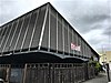 |
July 23, 2018 (#100002706) |
425 Franklin St. 47°02′40″N 122°53′57″W / 47.0444°N 122.8991°W | Olympia | |
| 7 | Chamber's Prairie-Ruddell Pioneer Cemetery |  |
June 30, 1995 (#95000803) |
Jct. of Ruddell and Mullen Rds., NW corner 47°00′34″N 122°48′23″W / 47.009444°N 122.806389°W | Lacey | |
| 8 | Cloverfields | 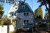 |
May 22, 1978 (#78002779) |
1100 Carlyon Ave., SE 47°01′15″N 122°53′06″W / 47.020833°N 122.885°W | Olympia | Built in 1914. |
| 9 | Colvin House |  |
June 23, 1988 (#88000693) |
16828 Old Hwy. 99 46°49′54″N 122°53′23″W / 46.831667°N 122.889722°W | Tenino | |
| 10 | Delphi School |  |
July 19, 1990 (#90001075) |
7601 SW. Delphi Rd. 46°58′47″N 123°01′07″W / 46.979722°N 123.018611°W | Delphi | |
| 11 | Dofflemyer Point Light |  |
May 1, 1995 (#93001339) |
211 NE. 73rd 47°08′26″N 122°54′21″W / 47.140556°N 122.905833°W | Boston Harbor | |
| 12 | Elks Building | 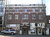 |
April 21, 1988 (#88000690) |
607-613 S. Capitol Way 47°02′34″N 122°54′02″W / 47.042778°N 122.900556°W | Olympia | Built in 1920. |
| 13 | Jonas and Maria Lovisa Erickson Farmstead |  |
March 20, 2002 (#02000251) |
13121 Independence Rd. 46°47′43″N 123°09′14″W / 46.795278°N 123.153889°W | Rochester | |
| 14 | Funk House |  |
May 8, 1987 (#87000691) |
1202 E. Olympia Ave. 47°02′53″N 122°53′14″W / 47.048056°N 122.887222°W | Olympia | |
| 15 | Gate School |  |
July 19, 1990 (#90001094) |
16925 Moon Rd. SW. 46°50′19″N 123°08′17″W / 46.838611°N 123.138056°W | Gate | |
| 16 | General Administration Building |  |
March 8, 2007 (#07000134) |
210 11th Ave. SW 47°02′17″N 122°54′08″W / 47.038056°N 122.902222°W | Olympia | Built in 1954. |
| 17 | Georgia-Pacific Plywood Company Office |  |
March 9, 2007 (#07000135) |
600 Capitol Way N. 47°03′02″N 122°54′01″W / 47.050556°N 122.900278°W | Olympia | Built in 1952. |
| 18 | Calvin and Pamela Hale House |  |
January 12, 1984 (#84003632) |
902 Tullis St., NE 47°03′07″N 122°53′00″W / 47.051944°N 122.883333°W | Olympia | Built in 1882. |
| 19 | Jaaska House and Warehouse |  |
June 23, 1988 (#88000702) |
11300 Independence Rd. 46°48′27″N 123°07′21″W / 46.8075°N 123.1225°W | Rochester | |
| 20 | Jeffers Studio |  |
June 17, 1987 (#87000870) |
500 and 502 S. Washington 47°02′39″N 122°53′57″W / 47.044167°N 122.899167°W | Olympia | Built in 1913. |
| 21 | Johnson House |  |
June 23, 1988 (#88000695) |
19540 Johnson Rd. 46°47′53″N 122°26′43″W / 46.798056°N 122.445278°W | Yelm | |
| 22 | Lackamas School |  |
May 10, 1990 (#90000707) |
16240, 16312 Bald Hill Rd. SE. 46°51′04″N 122°29′09″W / 46.851111°N 122.485833°W | Yelm | |
| 23 | Long Lake Recreation Hall |  |
June 23, 1988 (#88000697) |
3054 Carpenter Rd., SE 47°01′13″N 122°47′05″W / 47.020278°N 122.784722°W | Lacey | |
| 24 | C. J. Lord Mansion |  |
May 7, 1981 (#81000591) |
211 W. 21st Ave. 47°01′48″N 122°54′03″W / 47.03°N 122.900833°W | Olympia | Built in 1923; home to the Washington State Capital Museum |
| 25 | LOTUS (motor vessel) |  |
May 18, 1987 (#87000715) |
Fiddlehead Marina, B Dock 47°02′58″N 122°54′12″W / 47.049444°N 122.903333°W | Olympia | |
| 26 | Henry McCleary House |  |
October 2, 1978 (#78002780) |
111 21st Ave. SW 47°02′N 122°54′W / 47.03°N 122.9°W | Olympia | |
| 27 | Meyer House |  |
February 21, 1985 (#85000351) |
1136 E. Bay Dr. 47°03′17″N 122°53′30″W / 47.054722°N 122.891667°W | Olympia | |
| 28 | Miller-Brewer House |  |
June 23, 1988 (#88000694) |
17915 Guava 46°49′41″N 123°00′18″W / 46.828056°N 123.005°W | Rochester | |
| 29 | Millersylvania State Park |  |
September 16, 2009 (#09000732) |
12245 Tilley Rd. 46°54′42″N 122°54′22″W / 46.911639°N 122.906189°W | Olympia | |
| 30 | Mottman Building |  |
June 16, 1983 (#83003354) |
101-105 N. Capitol Way 47°02′42″N 122°54′02″W / 47.045°N 122.900556°W | Olympia | Built in 1890 |
| 31 | Nisqually School |  |
August 23, 1990 (#90001248) |
341 Nisqually Cut-Off Rd. SE 47°03′42″N 122°42′35″W / 47.061667°N 122.709722°W | Nisqually | |
| 32 | Old Capitol Building |  |
May 30, 1975 (#75001877) |
600 block Washington St. 47°02′35″N 122°53′53″W / 47.043056°N 122.898056°W | Olympia | Built in 1892 |
| 33 | Olympia Downtown Historic District |  |
September 15, 2004 (#04001008) |
Roughly bounded by State Ave., 8th Ave., Columbia St., and Franklin St. 47°22′32″N 122°53′59″W / 47.375556°N 122.899722°W | Olympia | |
| 34 | Olympia National Bank |  |
June 17, 1987 (#87000869) |
422 S. Capitol Way 47°02′40″N 122°54′00″W / 47.044444°N 122.9°W | Olympia | Built in 1915. |
| 35 | Olympia Public Library |  |
August 3, 1982 (#82004299) |
S. Franklin and E. 7th 47°02′34″N 122°53′50″W / 47.042778°N 122.897222°W | Olympia | Built in 1914. |
| 36 | Tugboat Parthia |  |
December 18, 2023 (#100009615) |
650 Marina Drive 47°03′05″N 122°53′47″W / 47.0515°N 122.8963°W | Olympia | |
| 37 | Charles Patnude House |  |
May 22, 1978 (#78002781) |
1239 8th Ave. 47°02′33″N 122°53′01″W / 47.0425°N 122.883611°W | Olympia | Built in 1893. |
| 38 | Rainier School |  |
March 10, 2004 (#04000159) |
Jct. of Algyers St. and Centre Sts. 46°53′19″N 122°41′14″W / 46.888611°N 122.687222°W | Rainier | |
| 39 | Reinhart-Young House |  |
May 8, 1987 (#87000712) |
1106 E. Olympia Ave. 47°02′52″N 122°53′21″W / 47.047778°N 122.889167°W | Olympia | Also known as Byrd House. |
| 40 | L. N. Rice House |  |
September 23, 1988 (#88000700) |
12247 Vail Rd., SE 46°54′34″N 122°34′20″W / 46.909444°N 122.572222°W | Yelm | |
| 41 | Rochester Elementary School |  |
May 17, 1990 (#90000784) |
10140 US 12 SW. 46°49′21″N 123°05′42″W / 46.8225°N 123.095°W | Rochester | |
| 42 | Frank Rudkin House |  |
May 8, 1987 (#87000713) |
1005 E. Olympia Ave. 47°02′50″N 122°53′18″W / 47.047222°N 122.888333°W | Olympia | |
| 43 | Salsich Lumber Company Superintendent's House |  |
June 23, 1988 (#88000696) |
10808 Vail Rd. 46°55′48″N 122°33′41″W / 46.93°N 122.561389°W | Yelm | |
| 44 | SAND MAN (Tug Boat) |  |
August 6, 1998 (#98001018) |
Berth A-108, East Bay Marina Port of Olympia 47°01′25″N 122°53′00″W / 47.023611°N 122.883333°W | Olympia | |
| 45 | F. W. Schmidt House |  |
June 30, 1995 (#95000801) |
2831 Orange 47°01′25″N 122°53′00″W / 47.023611°N 122.883333°W | Olympia | |
| 46 | Trueman and Virginia Schmidt House |  |
August 3, 2015 (#15000500) |
2932 Maringo Rd., SE 47°01′20″N 122°53′38″W / 47.022299°N 122.893921°W | Olympia | |
| 47 | Seatco Prison Site |  |
May 2, 1975 (#75001876) |
Off WA 507 46°47′35″N 122°52′11″W / 46.793056°N 122.869722°W | Bucoda | |
| 48 | South Capitol Neighborhood Historic District |  |
October 22, 1991 (#91001516) |
Roughly bounded by Capitol Lake, US 5 and 16th Ave. 47°01′51″N 122°53′57″W / 47.030833°N 122.899167°W | Olympia | |
| 49 | State Training School for Girls Administration Building |  |
June 23, 1988 (#88000701) |
20311 Old Hwy. 9 SW 46°47′31″N 123°01′39″W / 46.791944°N 123.0275°W | Rochester | |
| 50 | Alden Hatch Steele House |  |
June 18, 1992 (#92000783) |
1010 S. Franklin St. 47°02′23″N 122°53′48″W / 47.039722°N 122.896667°W | Olympia | Built in 1870. |
| 51 | Richard and Lydia Stoecker House |  |
December 15, 2015 (#15000910) |
1701 4th Ave. E. 47°02′45″N 122°52′44″W / 47.045809°N 122.878839°W | Olympia | |
| 52 | Tenino Depot |  |
December 27, 1974 (#74001982) |
399 Park Ave W 46°51′15″N 122°51′16″W / 46.854144°N 122.854335°W | Tenino | |
| 53 | Tenino Downtown Historic District | 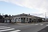 |
June 25, 2004 (#02001616) |
Sussex St. SE 46°51′26″N 122°51′11″W / 46.857225°N 122.853133°W | Tenino | |
| 54 | Tenino Stone Company Quarry |  |
July 28, 1983 (#83003355) |
City Park 46°51′16″N 122°51′10″W / 46.854459°N 122.852704°W | Tenino | |
| 55 | Thurston County Courthouse | 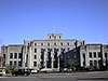 |
July 23, 1981 (#81000592) |
Capitol Way 47°02′16″N 122°53′56″W / 47.037778°N 122.898889°W | Olympia | Built in 1930. |
| 56 | Ticknor School |  |
May 10, 1990 (#90000708) |
399 Park Ave W. 46°51′15″N 122°51′16″W / 46.854144°N 122.854335°W | Tenino | |
| 57 | Town Square |  |
June 17, 1987 (#87000868) |
Bounded by Seventh, Legion, Capitol Way, and S. Washington 47°02′35″N 122°53′58″W / 47.043056°N 122.899444°W | Olympia | Established in 1850, this is now known as Sylvester Park. |
| 58 | Tumwater Historic District | 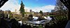 |
May 22, 1978 (#78002782) |
Roughly bounded by I-5, Capitol Way and Capitol Lake 47°01′07″N 122°54′08″W / 47.018611°N 122.902222°W | Tumwater | Includes 1860 Crosby House |
| 59 | Tumwater Methodist Church | 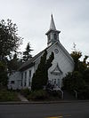 |
January 12, 1984 (#84003636) |
219 W. B St. 47°00′52″N 122°54′21″W / 47.014444°N 122.905833°W | Tumwater | |
| 60 | U.S. Post Office |  |
November 30, 1979 (#79002563) |
801 Capitol Way 47°02′29″N 122°54′05″W / 47.041359°N 122.901518°W | Olympia | Built in 1914. |
| 61 | Union Cemetery-Pioneer Calvary Cemetery |  |
April 14, 1997 (#97000323) |
5700 Littlerock Rd. 46°59′44″N 122°55′16″W / 46.995556°N 122.921111°W | Tumwater | |
| 62 | Union Mills Superintendent's House |  |
June 23, 1988 (#88000699) |
7716 Union Mills Rd. 47°01′59″N 122°46′25″W / 47.033056°N 122.773611°W | Olympia | |
| 63 | Washington State Capitol Historic District |  |
June 22, 1979 (#79002564) |
State Capitol and environs 47°02′11″N 122°54′09″W / 47.036389°N 122.9025°W | Olympia | |
| 64 | Washington State Library |  |
August 3, 2015 (#15000501) |
415 15th Ave., SE 47°02′04″N 122°54′17″W / 47.034405°N 122.904843°W | Olympia | Also known as Joel M. Pritchard Building. |
| 65 | Weyerhaeuser South Bay Log Dump Rural Historic Landscape |  |
October 2, 1991 (#91001441) |
609 Whitham Rd. 47°08′11″N 122°50′42″W / 47.136389°N 122.845°W | Olympia vicinity | Also known as the Woodard Bay Natural Resources Conservation Area. |
| 66 | Woman's Club of Olympia |  |
June 15, 1979 (#79002565) |
1002 Washington St. 47°02′23″N 122°53′53″W / 47.039722°N 122.898056°W | Olympia | Built in 1883. |
See also edit
Wikimedia Commons has media related to National Register of Historic Places in Thurston County, Washington.
References edit
- ^ The latitude and longitude information provided in this table was derived originally from the National Register Information System, which has been found to be fairly accurate for about 99% of listings. Some locations in this table may have been corrected to current GPS standards.
- ^ National Park Service, United States Department of the Interior, "National Register of Historic Places: Weekly List Actions", retrieved April 12, 2024.
- ^ Numbers represent an alphabetical ordering by significant words. Various colorings, defined here, differentiate National Historic Landmarks and historic districts from other NRHP buildings, structures, sites or objects.
- ^ The eight-digit number below each date is the number assigned to each location in the National Register Information System database, which can be viewed by clicking the number.