
KNOWPIA
WELCOME TO KNOWPIA

National Register of Historic Places listings in Tiverton, Rhode Island 
Summary
This is a list of Registered Historic Places in Tiverton, Rhode Island, which has been transferred from and is an integral part of National Register of Historic Places listings in Newport County, Rhode Island.
|
Bristol | Kent | Newport | Providence | Washington |
This National Park Service list is complete through NPS recent listings posted April 12, 2024.[1]
| [2] | Name on the Register[3] | Image | Date listed[4] | Location | City or town | Description |
|---|---|---|---|---|---|---|
| 1 | Bourne Mill |  |
December 22, 2006 (#06001189) |
844 State Ave. 41°40′12″N 71°10′41″W / 41.67°N 71.178056°W | Tiverton | Often grouped with the mills of nearby Fall River, Mass., but entirely within Rhode Island |
| 2 | Cook-Bateman Farm | 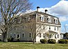 |
October 11, 1979 (#79003775) |
Fogland and Puncatest Neck Rds. 41°33′23″N 71°12′07″W / 41.5564°N 71.202°W | Tiverton | |
| 3 | First Baptist Church of Tiverton |  |
July 30, 2013 (#13000569) |
7 Old Stone Church Rd. 41°33′42″N 71°08′34″W / 41.5616°N 71.1427°W | Tiverton | |
| 4 | Fort Barton Site | 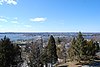 |
March 7, 1973 (#73000056) |
Lawton and Highland Aves. 41°37′47″N 71°12′37″W / 41.629722°N 71.210278°W | Tiverton | |
| 5 | Osborn-Bennett Historic District |  |
December 22, 2005 (#05001460) |
1137, 1148, 1168, 1188 Main Rd. 41°38′35″N 71°11′55″W / 41.643056°N 71.198611°W | Tiverton | |
| 6 | Tiverton Four Corners Historic District |  |
June 20, 1974 (#74000042) |
Roughly bounded by Main, West and East Rds. 41°34′17″N 71°11′18″W / 41.571389°N 71.188333°W | Tiverton |
See also edit
References edit
- ^ National Park Service, United States Department of the Interior, "National Register of Historic Places: Weekly List Actions", retrieved April 12, 2024.
- ^ Numbers represent an alphabetical ordering by significant words. Various colorings, defined here, differentiate National Historic Landmarks and historic districts from other NRHP buildings, structures, sites or objects.
- ^ "National Register Information System". National Register of Historic Places. National Park Service. March 13, 2009.
- ^ The eight-digit number below each date is the number assigned to each location in the National Register Information System database, which can be viewed by clicking the number.