


Summary
This is a list of the National Register of Historic Places listings in Torrance County, New Mexico.

This is intended to be a complete list of the properties and districts on the National Register of Historic Places in Torrance County, New Mexico, United States. Latitude and longitude coordinates are provided for many National Register properties and districts; these locations may be seen together in a map.[1]
There are 11 properties and districts listed on the National Register in the county, including 2 National Historic Landmarks and 1 National Monument. All of the places within the county on the National Register are also listed on the State Register of Cultural Properties with the single exception of Abo.
This National Park Service list is complete through NPS recent listings posted April 12, 2024.[2]
| Bernalillo – Catron – Chaves – Cibola – Colfax – Curry – De Baca – Doña Ana – Eddy – Grant – Guadalupe – Harding – Hidalgo – Lea – Lincoln – Los Alamos – Luna – McKinley – Mora – Otero – Quay – Rio Arriba – Roosevelt – San Juan – San Miguel – Sandoval – Santa Fe – Sierra – Socorro – Taos – Torrance – Union – Valencia |
Current listings edit
| [3] | Name on the Register[4] | Image | Date listed[5] | Location | City or town | Description |
|---|---|---|---|---|---|---|
| 1 | Abo | 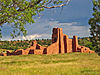 |
October 15, 1966 (#66000497) |
3 miles west of Abo on U.S. Route 60 34°26′56″N 106°22′17″W / 34.4489°N 106.3714°W | Abo | Part of Salinas Pueblo Missions National Monument |
| 2 | Duran Historic District | January 21, 2021 (#100005733) |
Roughly bounded by NM 3, Vidal and East Sts., and Park Ave. 34°28′11″N 105°23′46″W / 34.4698°N 105.3962°W | Duran | ||
| 3 | Gran Quivera Historic District | 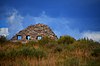 |
June 15, 2015 (#15000355) |
Along NM 55 approx. 25 mi. S. of Mountainair 34°15′55″N 106°06′09″W / 34.2654°N 106.1024°W | Mountainair vicinity | Part of Salinas Pueblo Missions National Monument; extends into Socorro County |
| 4 | Greene Evans Garage | 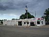 |
November 22, 1993 (#93001211) |
Northwestern corner of the junction of Broadway and former U.S. Route 66 35°00′19″N 106°03′00″W / 35.0053°N 106.05°W | Moriarty | |
| 5 | Moriarty Eclipse Windmill |  |
June 4, 1979 (#79001561) |
2 miles (3.2 km) west of Moriarty off State Road 222 34°59′48″N 106°04′55″W / 34.996667°N 106.081944°W | Moriarty | |
| 6 | Mountainair Municipal Auditorium |  |
April 30, 1987 (#87000651) |
Southwestern corner of Roosevelt Ave. and Beal St. 34°31′16″N 106°14′34″W / 34.5211°N 106.2428°W | Mountainair | |
| 7 | Quarai |  |
October 15, 1966 (#66000498) |
1 mile south of Punta de Agua 34°35′45″N 106°17′42″W / 34.5958°N 106.295°W | Punta de Agua | Part of Salinas Pueblo Missions National Monument |
| 8 | Rancho Bonito | 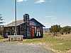 |
November 29, 1978 (#78001834) |
South of Mountainair on Gran Quivera Rd. 34°30′23″N 106°14′21″W / 34.5064°N 106.2392°W | Mountainair | |
| 9 | Salinas Pueblo Missions National Monument |  |
October 15, 1966 (#66000494) |
1 mile (1.6 km) east of Gran Quivira on State Road 10 34°15′35″N 106°05′25″W / 34.2597°N 106.0903°W | Mountainair | Extends into Socorro County |
| 10 | Shaffer Hotel |  |
November 15, 1978 (#78003077) |
Broadway St. 34°31′08″N 106°14′31″W / 34.5189°N 106.2419°W | Mountainair | |
| 11 | Willard Mercantile Company | 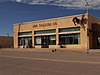 |
December 14, 2018 (#100003219) |
101 E. Broadway 34°31′13″N 106°14′24″W / 34.5204°N 106.2399°W | Mountainair |
See also edit
References edit
- ^ The latitude and longitude information provided in this table was derived originally from the National Register Information System, which has been found to be fairly accurate for about 99% of listings. Some locations in this table may have been corrected to current GPS standards.
- ^ National Park Service, United States Department of the Interior, "National Register of Historic Places: Weekly List Actions", retrieved April 12, 2024.
- ^ Numbers represent an alphabetical ordering by significant words. Various colorings, defined here, differentiate National Historic Landmarks and historic districts from other NRHP buildings, structures, sites or objects.
- ^ "National Register Information System". National Register of Historic Places. National Park Service. July 9, 2010.
- ^ The eight-digit number below each date is the number assigned to each location in the National Register Information System database, which can be viewed by clicking the number.