
KNOWPIA
WELCOME TO KNOWPIA

National Register of Historic Places listings in Tuscola County, Michigan 
Summary
The following is a list of Registered Historic Places in Tuscola County, Michigan.
This National Park Service list is complete through NPS recent listings posted April 12, 2024.[1]
| [2] | Name on the Register[3] | Image | Date listed[4] | Location | City or town | Description |
|---|---|---|---|---|---|---|
| 1 | R.C. Burtis House |  |
June 26, 1975 (#75000962) |
2163 S. Ringle Rd. 43°26′52″N 83°31′20″W / 43.447778°N 83.522222°W | Vassar | |
| 2 | First Presbyterian Church | 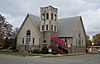 |
November 15, 2006 (#06001029) |
6505 Church St. 43°36′08″N 83°10′28″W / 43.602222°N 83.174444°W | Cass City | |
| 3 | Lovira Hart, Jr., and Esther Maria Parker Farm | 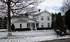 |
June 16, 2004 (#04000599) |
9491 Frankenmuth Rd. 43°20′07″N 83°40′34″W / 43.335278°N 83.676111°W | Tuscola | |
| 4 | Hotel Columbia | 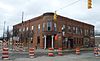 |
January 22, 1992 (#91001998) |
194 E. Huron Ave. 43°22′16″N 83°34′55″W / 43.371111°N 83.581944°W | Vassar | |
| 5 | Hotel Montague |  |
July 9, 1991 (#91000875) |
200 S. State St. 43°29′19″N 83°23′51″W / 43.488611°N 83.3975°W | Caro | |
| 6 | McKinley School |  |
March 24, 1972 (#72000655) |
510 Butler St. 43°22′05″N 83°34′35″W / 43.368056°N 83.576389°W | Vassar | |
| 7 | Millington Bank Building |  |
November 29, 1995 (#95001387) |
8534 State Rd. 43°16′49″N 83°31′49″W / 43.280278°N 83.530278°W | Millington | |
| 8 | William J. and Lovila (Wooley) Moore House |  |
March 27, 2024 (#100010162) |
123 North Almer St. 43°29′26″N 83°23′51″W / 43.490556°N 83.397500°W | Caro | |
| 9 | Townsend North House |  |
April 13, 1977 (#77000723) |
325 N. Main St. 43°22′31″N 83°34′33″W / 43.375278°N 83.575833°W | Vassar | |
| 10 | Randall House | 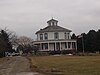 |
November 7, 1976 (#76001035) |
5927 Treasurer Rd. 43°20′22″N 83°19′20″W / 43.339444°N 83.322222°W | Mayville | Octagon house, built 1870 |
| 11 | Smith House |  |
March 16, 1972 (#72000656) |
113-115 Prospect St. 43°22′19″N 83°35′09″W / 43.371944°N 83.585833°W | Vassar | |
| 12 | Trinity Episcopal Church |  |
May 12, 1975 (#75000961) |
106 Joy St. 43°29′16″N 83°23′48″W / 43.487778°N 83.396667°W | Caro | |
| 13 | Tuscola County Courthouse |  |
December 6, 1996 (#96001419) |
440 N. State St. 43°29′27″N 83°23′35″W / 43.490833°N 83.393056°W | Caro | |
| 14 | Watrous General Store |  |
October 1, 1974 (#74000998) |
4607 W. Caro Rd. 43°27′06″N 83°31′28″W / 43.451667°N 83.524444°W | Watrousville |
See also edit
Wikimedia Commons has media related to National Register of Historic Places in Tuscola County, Michigan.
References edit
- ^ National Park Service, United States Department of the Interior, "National Register of Historic Places: Weekly List Actions", retrieved April 12, 2024.
- ^ Numbers represent an alphabetical ordering by significant words. Various colorings, defined here, differentiate National Historic Landmarks and historic districts from other NRHP buildings, structures, sites or objects.
- ^ "National Register Information System". National Register of Historic Places. National Park Service. April 24, 2008.
- ^ The eight-digit number below each date is the number assigned to each location in the National Register Information System database, which can be viewed by clicking the number.