
KNOWPIA
WELCOME TO KNOWPIA

National Register of Historic Places listings in Washakie County, Wyoming 
Summary
This is a list of the National Register of Historic Places listings in Washakie County, Wyoming. It is intended to be a complete list of the properties and districts on the National Register of Historic Places in Washakie County, Wyoming, United States. The locations of National Register properties and districts for which the latitude and longitude coordinates are included below, may be seen in a map.[1]
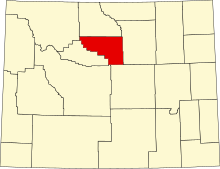
There are 7 properties and districts listed on the National Register in the county.
This National Park Service list is complete through NPS recent listings posted April 5, 2024.[2]
| Albany - Big Horn - Campbell - Carbon - Converse - Crook - Fremont - Goshen - Hot Springs - Johnson - Laramie - Lincoln - Natrona - Niobrara - Park - Platte - Sheridan - Sublette - Sweetwater - Teton - Uinta - Washakie - Weston |
Listings county-wide edit
| [3] | Name on the Register | Image | Date listed[4] | Location | City or town | Description |
|---|---|---|---|---|---|---|
| 1 | Ainsworth House |  |
September 11, 1986 (#86002321) |
Spring Creek Rd. 43°47′49″N 107°18′49″W / 43.796858°N 107.313731°W | Big Trails | Vernacular cabin built in stages 1886–1911, significant as one of the first permanent houses in the Bighorn Basin and as a symbol of the area's shift from large open-range ranching to small owner-occupied homesteads.[5] |
| 2 | Emerson Parks House |  |
May 16, 2016 (#16000265) |
504 2nd St. 44°02′01″N 107°26′38″W / 44.033657°N 107.443965°W | Ten Sleep | 1929 two-story log house, one of the few surviving buildings from Ten Sleep's early years.[6] |
| 3 | James T. Saban Lookout |  |
November 15, 2016 (#16000781) |
Approx..9 mi. SW. of US 16 & FS Rd. 429 44°08′58″N 107°12′08″W / 44.149319°N 107.202334°W | Ten Sleep vicinity | 1942 fire lookout tower, a well-preserved attestation of early-20th-century firefighting efforts in U.S. national forests and of Civilian Conservation Corps contributions in Wyoming.[7] |
| 4 | Ten Sleep Mercantile |  |
September 11, 1986 (#86002324) |
201 2nd St. 44°02′03″N 107°26′59″W / 44.034225°N 107.449661°W | Ten Sleep | 1905 general store exemplifying the initial commercial establishments serving the essential needs of frontier ranchers, and a longstanding focal point of Ten Sleep.[8] |
| 5 | West Side School |  |
November 17, 2021 (#100007002) |
100 South 3rd St. 44°00′59″N 107°57′56″W / 44.016484°N 107.965465°W | Worland | Wyoming's only known public school specifically built for the segregation of Mexican-American students, active 1936–1956.[9] |
| 6 | Worland House |  |
February 27, 1986 (#86000310) |
520 Culbertson Ave. 44°00′52″N 107°57′41″W / 44.01451°N 107.961525°W | Worland | Exemplary 1917 bungalow style house of Charlie C. Worland, son of Worland's founder and the city's most influential early businessman and entrepreneur.[10] |
| 7 | Worland Ranch | 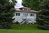 |
March 5, 1992 (#92000123) |
801 U.S. Route 20 44°00′41″N 107°58′51″W / 44.011389°N 107.980833°W | Worland | Ranch of Worland's founder C.H. "Dad" Worland (1844–1933), consisting of the original 1900 townsite and 10 contributing ranch properties built 1917–1918.[11] |
See also edit
Wikimedia Commons has media related to National Register of Historic Places in Washakie County, Wyoming.
References edit
- ^ The latitude and longitude information provided in this table was derived originally from the National Register Information System, which has been found to be fairly accurate for about 99% of listings. Some locations in this table may have been corrected to current GPS standards.
- ^ National Park Service, United States Department of the Interior, "National Register of Historic Places: Weekly List Actions", retrieved April 5, 2024.
- ^ Numbers represent an alphabetical ordering by significant words. Various colorings, defined here, differentiate National Historic Landmarks and historic districts from other NRHP buildings, structures, sites or objects.
- ^ The eight-digit number below each date is the number assigned to each location in the National Register Information System database, which can be viewed by clicking the number.
- ^ Davidson, Hugh Roe (1985-09-10). National Register of Historic Places Inventory—Nomination Form: Ainsworth House. National Park Service. Retrieved 2023-07-06.
- ^ Chaney, Barbara (2016-04-01). National Register of Historic Places Registration Form: Parks, Emerson, House. National Park Service. Retrieved 2023-07-05.
- ^ Schneider, Matthew Lee (2016-07-13). National Register of Historic Places Registration Form: High Park Lookout. National Park Service. Retrieved 2023-07-04.
- ^ Davidson, Hugh Roe (1985-09-10). National Register of Historic Places Inventory—Nomination Form: Ten Sleep Mercantile. National Park Service. Retrieved 2023-07-03.
- ^ Guzman, Gonzalo; Bathany Kelly (2021-06-01). National Register of Historic Places Registration Form: West Side School (PDF). National Park Service. Retrieved 2023-07-02.
- ^ Davis, John W.; Jamie Wells (1984). National Register of Historic Places Inventory—Nomination Form: Worland House. National Park Service. Retrieved 2023-07-01.
- ^ Massey, Rheba; Mike Johnson (1991-07-03). National Register of Historic Places Inventory Registration Form: Worland Ranch. National Park Service. Retrieved 2023-07-01.