
KNOWPIA
WELCOME TO KNOWPIA

National Register of Historic Places listings in Washington County, Georgia 
Summary
This is a list of properties and districts in Washington County, Georgia that are listed on the National Register of Historic Places (NRHP).

This National Park Service list is complete through NPS recent listings posted April 12, 2024.[1]
Current listings edit
| [2] | Name on the Register | Image | Date listed[3] | Location | City or town | Description |
|---|---|---|---|---|---|---|
| 1 | Church-Smith-Harris Street Historic District | December 31, 1987 (#87001268) |
E. Church, S. Smith, and S. Harris Sts. 32°58′44″N 82°48′29″W / 32.978889°N 82.808056°W | Sandersville | ||
| 2 | City Cemetery | 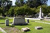 |
August 3, 1987 (#87001296) |
W. Church, Cemetery, and Haynes Sts. 32°58′57″N 82°48′55″W / 32.9825°N 82.815278°W | Sandersville | |
| 3 | Thomas Jefferson Elder High and Industrial School |  |
May 12, 1981 (#81000202) |
316 Hall St. 32°58′38″N 82°48′58″W / 32.97730°N 82.81605°W | Sandersville | |
| 4 | Forest Grove | January 26, 2005 (#04001556) |
1200 GA 242/Riddleville Rd. 32°57′51″N 82°47′25″W / 32.96416°N 82.79021°W | Sandersville | library web page | |
| 5 | Francis Plantation | July 3, 1975 (#75000616) |
SE of Davisboro on SR 2189 (Josey Church Road?) 32°55′52″N 82°33′28″W / 32.931111°N 82.557778°W | Davisboro | ||
| 6 | Holt Brothers Banking Company Building |  |
July 28, 1994 (#94000710) |
100-106 Malone St. 32°59′02″N 82°48′39″W / 32.98385°N 82.81092°W | Sandersville | |
| 7 | James E. Johnson House |  |
July 28, 1994 (#94000711) |
425 W. Church St. 32°58′54″N 82°49′03″W / 32.98155°N 82.81745°W | Sandersville | |
| 8 | James Kelley House | July 28, 1994 (#94000712) |
Tennille-Harrison Rd. E of jct. with GA 15 32°55′53″N 82°48′01″W / 32.93130°N 82.80018°W | Tennille | ||
| 9 | Charles Madden House |  |
July 28, 1994 (#94000713) |
302 E. South Central St. 32°56′12″N 82°48′28″W / 32.93677°N 82.80790°W | Tennille | |
| 10 | North Harris Street Historic District | July 20, 1989 (#89000801) |
Roughly bounded by First Ave., Washington Ave., E. McCarty St., N. Harris St., Malone St., and Warthen St. 32°59′20″N 82°48′37″W / 32.988889°N 82.810278°W | Sandersville | ||
| 11 | Sandersville Commercial and Industrial District |  |
March 1, 2002 (#02000120) |
Roughly Jernigan, Gilmore, North Smith, East Haynes, W. Haynes, and Warthen Sts. 32°59′03″N 82°48′35″W / 32.984167°N 82.809722°W | Sandersville | |
| 12 | Sandersville High School | December 9, 2019 (#100004745) |
514 North Harris St. 32°59′41″N 82°48′33″W / 32.9946°N 82.8091°W | Sandersville | ||
| 13 | Thomas W. Smith House |  |
July 28, 1994 (#94000714) |
306 N. Main St. 32°56′21″N 82°48′38″W / 32.939141°N 82.81049°W | Tennille | |
| 14 | Tennille Banking Company Building |  |
July 28, 1994 (#94000715) |
102-104 N. Main St. 32°56′11″N 82°48′41″W / 32.936389°N 82.811389°W | Tennille | |
| 15 | Tennille Baptist Church | 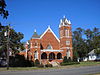 |
July 28, 1994 (#94000716) |
201-205 N. Main St. 32°56′20″N 82°48′41″W / 32.93876°N 82.81137°W | Tennille | |
| 16 | Tennille Woman's Clubhouse | 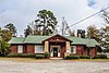 |
July 1, 1998 (#98000815) |
132 Smith St. 32°56′16″N 82°48′45″W / 32.93777°N 82.81259°W | Tennille | |
| 17 | Warthen Historic District | 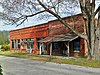 |
July 25, 1997 (#97000755) |
Jct. of GA 15, GA 102, Warthen St., Old Sadersville-Sparta and Walker Dairy Rds. 33°06′12″N 82°48′18″W / 33.103333°N 82.805°W | Warthen | |
| 18 | Washington County Courthouse |  |
September 18, 1980 (#80001260) |
Courthouse Sq. 32°59′00″N 82°48′43″W / 32.983333°N 82.811944°W | Sandersville | Is also in the Sandersville Commercial and Industrial District |
| 19 | Washington Manufacturing Company | July 28, 1994 (#94000717) |
Between E. Montgomery and Church Sts. at White Line St. 32°56′33″N 82°48′16″W / 32.94241°N 82.80443°W | Tennille | Main building has been demolished | |
| 20 | Wrightsville and Tennille Railroad Company Building | 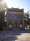 |
July 28, 1994 (#94000718) |
119 Central Ave. 32°56′06″N 82°48′46″W / 32.93500°N 82.81276°W | Tennille |
References edit
Wikimedia Commons has media related to National Register of Historic Places in Washington County, Georgia.
- ^ National Park Service, United States Department of the Interior, "National Register of Historic Places: Weekly List Actions", retrieved April 12, 2024.
- ^ Numbers represent an alphabetical ordering by significant words. Various colorings, defined here, differentiate National Historic Landmarks and historic districts from other NRHP buildings, structures, sites or objects.
- ^ The eight-digit number below each date is the number assigned to each location in the National Register Information System database, which can be viewed by clicking the number.