
KNOWPIA
WELCOME TO KNOWPIA

National Register of Historic Places listings in Weakley County, Tennessee 
Summary
This is a list of the National Register of Historic Places listings in Weakley County, Tennessee.

This is intended to be a complete list of the properties and districts on the National Register of Historic Places in Weakley County, Tennessee, United States. Latitude and longitude coordinates are provided for many National Register properties and districts; these locations may be seen together in a map.[1]
There are 12 properties and districts listed on the National Register in the county. Another site was once listed but has been removed.
| Anderson – Bedford – Benton – Bledsoe – Blount – Bradley – Campbell – Cannon – Carroll – Carter – Cheatham – Chester – Claiborne – Clay – Cocke – Coffee – Crockett – Cumberland – Davidson – Decatur – DeKalb – Dickson – Dyer – Fayette – Fentress – Franklin – Gibson – Giles – Grainger – Greene – Grundy – Hamblen – Hamilton – Hancock – Hardeman – Hardin – Hawkins – Haywood – Henderson – Henry – Hickman – Houston – Humphreys – Jackson – Jefferson – Johnson – Knox – Lake – Lauderdale – Lawrence – Lewis – Lincoln – Loudon – Macon – Madison – Marion – Marshall – Maury – McMinn – McNairy – Meigs – Monroe – Montgomery – Moore – Morgan – Obion – Overton – Perry – Pickett – Polk – Putnam – Rhea – Roane – Robertson – Rutherford – Scott – Sequatchie – Sevier – Shelby – Smith – Stewart – Sullivan – Sumner – Tipton – Trousdale – Unicoi – Union – Van Buren – Warren – Washington – Wayne – Weakley – White – Williamson – Wilson |
This National Park Service list is complete through NPS recent listings posted April 5, 2024.[2]
Current listings edit
| [3] | Name on the Register[4] | Image | Date listed[5] | Location | City or town | Description |
|---|---|---|---|---|---|---|
| 1 | Dr. Robert W. Bandy House | August 9, 1984 (#84003726) |
College St. 36°12′45″N 88°36′48″W / 36.2125°N 88.613333°W | Gleason | ||
| 2 | William Parker Caldwell House | 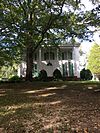 |
March 9, 1979 (#79002485) |
Off State Route 22 36°21′55″N 88°53′37″W / 36.365278°N 88.893611°W | Gardner | |
| 3 | Cary Lawn | June 18, 1992 (#92000779) |
321 Linden St. 36°17′16″N 88°42′18″W / 36.287778°N 88.705°W | Dresden | ||
| 4 | First Christian Church | November 15, 2002 (#02001338) |
308 College St 36°12′46″N 88°36′49″W / 36.212778°N 88.613611°W | Gleason | ||
| 5 | Ivandale |  |
March 25, 1982 (#82004067) |
115 N. McCombs St. 36°20′38″N 88°50′49″W / 36.343889°N 88.846944°W | Martin | |
| 6 | W.T. Lawler House |  |
March 25, 1982 (#82004068) |
229 University St. 36°20′34″N 88°51′24″W / 36.342778°N 88.856667°W | Martin | |
| 7 | Marshalldale |  |
March 25, 1982 (#82004069) |
115 Ryan Ave. 36°20′12″N 88°50′57″W / 36.336667°N 88.849167°W | Martin | |
| 8 | Martin Downtown Commercial Historic District | 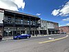 |
July 10, 2023 (#100009137) |
District boundary encompasses the main commercial corridor along the 200, 300, and 400 blks. of Lindell St., and the 300 block of Broadway. 36°20′36″N 88°51′02″W / 36.3433°N 88.8505°W | Martin | |
| 9 | Capt. William Sims House | March 25, 1982 (#82004066) |
Route 2, Liberty Rd. 36°12′13″N 88°42′26″W / 36.203611°N 88.707222°W | Greenfield | ||
| 10 | University Street Historic District | July 5, 1996 (#96000750) |
225-248 University St. 36°20′35″N 88°51′23″W / 36.343056°N 88.856389°W | Martin | ||
| 11 | US Post Office |  |
July 5, 1996 (#96000751) |
100 Main St. 36°20′37″N 88°50′21″W / 36.343611°N 88.839167°W | Martin | |
| 12 | Varsity Theatre |  |
July 16, 2010 (#10000464) |
104 Oxford St. 36°20′36″N 88°51′05″W / 36.343333°N 88.851389°W | Martin |
Former listings edit
| [3] | Name on the Register | Image | Date listed | Date removed | Location | City or town | Description |
|---|---|---|---|---|---|---|---|
| 1 | Oakland | April 22, 1982 (#82004065) | March 17, 2010 | State Routes 22 and 89 36°17′05″N 88°43′45″W / 36.2847°N 88.7292°W | Dresden |
See also edit
Wikimedia Commons has media related to National Register of Historic Places in Weakley County, Tennessee.
References edit
- ^ The latitude and longitude information provided in this table was derived originally from the National Register Information System, which has been found to be fairly accurate for about 99% of listings. Some locations in this table may have been corrected to current GPS standards.
- ^ National Park Service, United States Department of the Interior, "National Register of Historic Places: Weekly List Actions", retrieved April 5, 2024.
- ^ a b Numbers represent an alphabetical ordering by significant words. Various colorings, defined here, differentiate National Historic Landmarks and historic districts from other NRHP buildings, structures, sites or objects.
- ^ "National Register Information System". National Register of Historic Places. National Park Service. April 24, 2008.
- ^ The eight-digit number below each date is the number assigned to each location in the National Register Information System database, which can be viewed by clicking the number.