
KNOWPIA
WELCOME TO KNOWPIA

National Register of Historic Places listings in Wilson County, North Carolina 
Summary
This list includes properties and districts listed on the National Register of Historic Places in Wilson County, North Carolina. Click the "Map of all coordinates" link to the right to view a Google map of all properties and districts with latitude and longitude coordinates in the table below.[1]

This National Park Service list is complete through NPS recent listings posted April 12, 2024.[2]
Current listings edit
| [3] | Name on the Register[4] | Image | Date listed[5] | Location | City or town | Description |
|---|---|---|---|---|---|---|
| 1 | W. H. Applewhite House | February 13, 1986 (#86000696) |
Off NC 58 35°37′25″N 77°49′18″W / 35.623611°N 77.821667°W | Stantonsburg | ||
| 2 | Manalcus Aycock House | February 13, 1986 (#86000765) |
Center St. 35°38′05″N 77°56′02″W / 35.634722°N 77.933889°W | Black Creek | ||
| 3 | Gen. Joshua Barnes House | February 13, 1986 (#86000764) |
W side of SR 1326 at SR 1327 35°45′44″N 77°54′09″W / 35.762222°N 77.9025°W | Wilson | ||
| 4 | Black Creek Rural Historic District | October 14, 1986 (#86001659) |
Along NC 1628 35°37′36″N 77°53′22″W / 35.626667°N 77.889444°W | Black Creek | ||
| 5 | Branch Banking |  |
August 11, 1978 (#78001986) |
124 E. Nash St.[6] 35°43′30″N 77°54′38″W / 35.725018°N 77.910522°W | Wilson | |
| 6 | Broad-Kenan Streets Historic District | 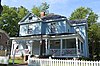 |
October 27, 1988 (#88002084) |
Roughly bounded by Pine, Broad, Hines, and Cone 35°43′44″N 77°55′04″W / 35.728889°N 77.917778°W | Wilson | |
| 7 | Bullock-Dew House | February 13, 1986 (#86000759) |
NC 581 35°44′22″N 78°06′43″W / 35.739444°N 78.111944°W | Sims | ||
| 8 | Cherry Hotel | 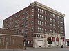 |
August 26, 1982 (#82003531) |
333 E. Nash St. 35°43′24″N 77°54′30″W / 35.723418°N 77.908412°W | Wilson | |
| 9 | Davis-Whitehead-Harriss House |  |
June 14, 1982 (#82003532) |
600 W. Nash St. 35°43′57″N 77°54′57″W / 35.732423°N 77.915887°W | Wilson | |
| 10 | East Wilson Historic District |  |
April 11, 1988 (#88000371) |
Roughly bounded by E. Gold and Academy Sts., Ward Blvd., Woodard Street Ave. and Elvie St., and Railroad and Pender Sts. 35°43′10″N 77°54′10″W / 35.719444°N 77.902778°W | Wilson | |
| 11 | Edmondson-Woodward House | February 13, 1986 (#86000767) |
NC 58 and SR 1542 35°39′08″N 77°49′57″W / 35.652222°N 77.8325°W | Stantonsburg | ||
| 12 | Elm City Municipal Historic District | February 13, 1986 (#86000770) |
Roughly bounded by North, Pender and Branch, Wilson, and Anderson Sts. 35°48′28″N 77°51′45″W / 35.807778°N 77.8625°W | Elm City | ||
| 13 | W. H. Langley House | 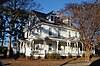 |
February 13, 1986 (#86000763) |
N side of SR 1003 35°48′31″N 77°52′45″W / 35.808611°N 77.879167°W | Elm City | |
| 14 | Lucama Municipal Historic District | February 13, 1986 (#86000772) |
Roughly bounded by US 301 and Railroad St., Main St., Black Creek Rd., and Goldsboro St. 35°38′35″N 78°00′38″W / 35.643056°N 78.010556°W | Lucama | ||
| 15 | Dr. H. D. Lucas House | February 13, 1986 (#86000771) |
Center St. 35°38′12″N 77°56′04″W / 35.636667°N 77.934444°W | Black Creek | Demolished[7] | |
| 16 | Old Wilson Historic District |  |
December 20, 1984 (#84000736) |
Roughly bounded by Nash, N. Cone, Gold and Railroad Sts. and Maplewood Cemetery 35°43′51″N 77°54′38″W / 35.730833°N 77.910556°W | Wilson | |
| 17 | Joseph John Pender House | February 13, 1986 (#86000766) |
SR 1418 and SR 1002 35°46′17″N 77°46′28″W / 35.771389°N 77.774444°W | Wilson | ||
| 18 | Moses Rountree House | 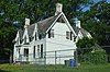 |
April 26, 1982 (#82003533) |
107 N. Rountree St. 35°44′03″N 77°54′59″W / 35.734167°N 77.916389°W | Wilson | |
| 19 | Maj. James Scarborough House | June 14, 1982 (#82003530) |
NC 222 35°39′46″N 77°46′03″W / 35.662778°N 77.7675°W | Saratoga | ||
| 20 | Alfred and Martha Jane Thompson House and Williams Barn | February 14, 2002 (#02000007) |
NC 1314, 0.4 miles W of NC 58 35°48′36″N 77°57′18″W / 35.81°N 77.955°W | New Hope | ||
| 21 | Upper Town Creek Rural Historic District | August 29, 1986 (#86001656) |
Roughly bounded by NC 1003, NC 1411, NC 1414, and Town Creek 35°47′57″N 77°45′25″W / 35.799167°N 77.756944°W | Wilson | ||
| 22 | Ward-Applewhite-Thompson House | February 13, 1986 (#86000695) |
S side of SR 1539 35°36′16″N 77°47′47″W / 35.604444°N 77.796389°W | Stantonsburg | ||
| 23 | Webb-Barron-Wells House | February 13, 1986 (#86000769) |
E side SR 1512 35°45′37″N 77°44′08″W / 35.760278°N 77.735556°W | Elm City | ||
| 24 | West Nash Street Historic District | 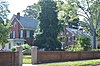 |
December 20, 1984 (#84001033) |
West Nash St. 35°44′18″N 77°55′14″W / 35.738333°N 77.920556°W | Wilson | |
| 25 | Olzie Whitehead Williams House |  |
December 19, 1983 (#83004004) |
SR 1332 35°47′22″N 77°55′08″W / 35.789444°N 77.918889°W | Wilson | |
| 26 | Wilson Central Business-Tobacco Warehouse Historic District |  |
December 20, 1984 (#84003876) |
Roughly bounded by Pender, Green, Pine, S. Jackson, and Hines Sts. 35°43′26″N 77°54′41″W / 35.723936°N 77.911389°W | Wilson | |
| 27 | Wilson County Courthouse |  |
May 10, 1979 (#79001765) |
Nash at Goldsboro St. 35°43′32″N 77°54′37″W / 35.725474°N 77.910279°W | Wilson | |
| 28 | Woodard Family Rural Historic District | August 29, 1986 (#86001657) |
Along US 264 35°41′30″N 77°50′18″W / 35.691667°N 77.838333°W | Wilson |
See also edit
Wikimedia Commons has media related to National Register of Historic Places in Wilson County, North Carolina.
References edit
- ^ The latitude and longitude information provided in this table was derived originally from the National Register Information System, which has been found to be fairly accurate for about 99% of listings. Some locations in this table may have been corrected to current GPS standards.
- ^ National Park Service, United States Department of the Interior, "National Register of Historic Places: Weekly List Actions", retrieved April 12, 2024.
- ^ Numbers represent an alphabetical ordering by significant words. Various colorings, defined here, differentiate National Historic Landmarks and historic districts from other NRHP buildings, structures, sites or objects.
- ^ "National Register Information System". National Register of Historic Places. National Park Service. April 24, 2008.
- ^ The eight-digit number below each date is the number assigned to each location in the National Register Information System database, which can be viewed by clicking the number.
- ^ See "Historic Landmarks" Archived 2012-05-12 at the Wayback Machine, City of Wilson, retrieved 2014-12-23; and "Historic Walking Tour Downtown Wilson" Archived 2014-12-16 at the Wayback Machine, Wilson: Simply Wonderful Archived 2014-12-16 at the Wayback Machine, retrieved 2014-12-23.
- ^ "North Carolina Listings in the National Register of Historic Places by County". North Carolina State Historic Preservation Office. 22 October 2008. Archived from the original on 30 November 2012. Retrieved 14 July 2009.