


Summary
This is a list of the National Register of Historic Places listings in York County, South Carolina.

This is intended to be a complete list of the properties and districts on the National Register of Historic Places in York County, South Carolina, United States. The locations of National Register properties and districts for which the latitude and longitude coordinates are included below, may be seen on a map.[1]
There are 60 properties and districts listed on the National Register in the county. The city of Rock Hill is the location of 28 of these properties and districts; they are listed separately, while the 32 properties and districts in the remaining parts of the county are listed here.
This National Park Service list is complete through NPS recent listings posted April 12, 2024.[2]
Current listings edit
| [3] | Name on the Register[4] | Image | Date listed[5] | Location | City or town | Description |
|---|---|---|---|---|---|---|
| 1 | Allison Plantation |  |
September 29, 1980 (#80003716) |
Off South Carolina Highways 40 and 60 35°00′08″N 81°22′32″W / 35.002222°N 81.375556°W | York | |
| 2 | Banks-Mack House | 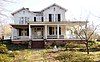 |
June 11, 1992 (#92000643) |
329 Confederate St. 35°00′11″N 80°56′18″W / 35.003056°N 80.938333°W | Fort Mill | |
| 3 | Bethel Presbyterian Church |  |
December 10, 1980 (#80003714) |
South Carolina Highway 557 35°06′41″N 81°09′11″W / 35.111389°N 81.153056°W | Clover | |
| 4 | Bethesda Presbyterian Church |  |
August 16, 1977 (#77001233) |
3.5 miles northeast of McConnells on South Carolina Highway 322 34°53′52″N 81°10′32″W / 34.897778°N 81.175556°W | McConnells | |
| 5 | Brattonsville Historic District |  |
August 19, 1971 (#71000812) |
East of McConnells on County Road 165 off South Carolina Highway 322 34°52′04″N 81°10′39″W / 34.867778°N 81.1775°W | McConnells | |
| 6 | Carroll Rosenwald School | 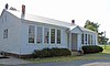 |
June 25, 2018 (#100002600) |
4789 Mobley Store Rd. 34°51′06″N 81°09′34″W / 34.8516°N 81.1595°W | Rock Hill | |
| 7 | Clover Downtown Historic District |  |
July 8, 1999 (#99000816) |
Junction of Main and Kings Mountain Sts. 35°06′42″N 81°13′36″W / 35.111667°N 81.226667°W | Clover | |
| 8 | Fort Mill Downtown Historic District |  |
June 11, 1992 (#92000646) |
Main St. from Confederate Park east to 233 Main 35°00′28″N 80°56′39″W / 35.007778°N 80.944167°W | Fort Mill | |
| 9 | Hart House |  |
December 2, 1977 (#77001236) |
220 E. Liberty St. 34°59′29″N 81°14′12″W / 34.991389°N 81.236667°W | York | |
| 10 | Hightower Hall |  |
June 28, 1982 (#82003907) |
County Road 165 34°52′52″N 81°10′53″W / 34.881111°N 81.181389°W | McConnells | |
| 11 | Hill Complex Historic District |  |
April 18, 2003 (#03000273) |
York and Shannon Sts. 34°57′09″N 81°20′12″W / 34.9525°N 81.336667°W | Sharon | |
| 12 | W.L. Hill Store |  |
January 20, 1995 (#94001572) |
3034 York St. 34°57′05″N 81°20′18″W / 34.951389°N 81.338333°W | Sharon | |
| 13 | Jackson's Furnace Site (38YK217) | May 8, 1987 (#87000706) |
Address Restricted | Smyrna | ||
| 14 | Kings Mountain National Military Park |  |
October 15, 1966 (#66000079) |
Northwest of Bethany on South Carolina Highway 161 35°08′16″N 81°23′22″W / 35.137778°N 81.389444°W | Bethany | Extends into Cherokee County |
| 15 | Mack-Belk House | 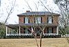 |
June 11, 1992 (#92000647) |
119 Banks St. 35°00′24″N 80°56′06″W / 35.006667°N 80.935°W | Fort Mill | |
| 16 | Mills House |  |
June 11, 1992 (#92000645) |
122 Confederate St. 35°00′23″N 80°56′36″W / 35.006389°N 80.943333°W | Fort Mill | |
| 17 | Nation Ford Road |  |
March 1, 2007 (#00000593) |
5 noncontiguous sections of roadbed in Fort Mill 34°59′43″N 80°57′06″W / 34.995278°N 80.951667°W | Fort Mill | |
| 18 | National Guard Armory |  |
June 11, 1992 (#92000648) |
Junction of Elliott and Unity Sts. 35°00′34″N 80°56′21″W / 35.009444°N 80.939167°W | Fort Mill | |
| 19 | Sadler Store |  |
October 16, 2017 (#100001749) |
405 S. Congress St. 34°59′15″N 81°14′47″W / 34.987400°N 81.246392°W | York | |
| 20 | Sharon Downtown Historic District | 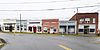 |
November 2, 2001 (#01001202) |
York St. and Woodlawn Ave. 34°57′06″N 81°20′30″W / 34.951667°N 81.341667°W | Sharon | |
| 21 | Spratt Cemetery | 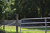 |
March 1, 2007 (#00000597) |
Brickyard Rd. 34°59′58″N 80°57′10″W / 34.999444°N 80.952778°W | Fort Mill | |
| 22 | Springfield Plantation House |  |
September 12, 1985 (#85002387) |
U.S. Route 21 35°02′54″N 80°55′41″W / 35.048333°N 80.928056°W | Fort Mill | |
| 23 | Thornwell-Elliott House | 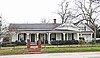 |
June 11, 1992 (#92000644) |
118 Confederate St. 35°00′24″N 80°56′37″W / 35.006667°N 80.943611°W | Fort Mill | |
| 24 | Unity Presbyterian Church Complex |  |
June 11, 1992 (#92000649) |
303 Tom Hall St. 35°00′33″N 80°56′16″W / 35.009167°N 80.937778°W | Fort Mill | |
| 25 | John M. White House |  |
September 12, 1985 (#85002385) |
White and Skipper Sts. 35°00′36″N 80°56′50″W / 35.01°N 80.947222°W | Fort Mill | |
| 26 | William Elliott White House |  |
March 22, 1987 (#87000381) |
N. White St. 35°00′57″N 80°57′01″W / 35.015833°N 80.950278°W | Fort Mill | |
| 27 | Wilson House |  |
June 11, 1992 (#92000650) |
107 Clebourne St. 35°00′31″N 80°56′38″W / 35.008611°N 80.943889°W | Fort Mill | |
| 28 | Wilson House |  |
November 20, 1974 (#74001887) |
3 S. Congress St. 34°59′36″N 81°14′32″W / 34.993333°N 81.242222°W | York | |
| 29 | Witherspoon-Hunter House |  |
February 7, 1978 (#78002536) |
15 W. Liberty St. 34°59′50″N 81°14′37″W / 34.997222°N 81.243611°W | York | |
| 30 | York County Courthouse |  |
October 30, 1981 (#81000700) |
Corner of W. Liberty and S. Congress Sts. 34°59′39″N 81°14′33″W / 34.99403°N 81.242493°W | York | |
| 31 | York Graded School | May 23, 2023 (#100008988) |
212 East Jefferson St. 34°59′25″N 81°14′23″W / 34.9903°N 81.2398°W | York | ||
| 32 | York Historic District | 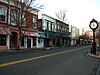 |
October 18, 1979 (#79002396) |
U.S. Route 321 and South Carolina Highway 5 34°59′53″N 81°13′35″W / 34.998056°N 81.226389°W | York |
See also edit
References edit
- ^ The latitude and longitude information provided in this table was derived originally from the National Register Information System, which has been found to be fairly accurate for about 99% of listings. Some locations in this table may have been corrected to current GPS standards.
- ^ National Park Service, United States Department of the Interior, "National Register of Historic Places: Weekly List Actions", retrieved April 12, 2024.
- ^ Numbers represent an alphabetical ordering by significant words. Various colorings, defined here, differentiate National Historic Landmarks and historic districts from other NRHP buildings, structures, sites or objects.
- ^ "National Register Information System". National Register of Historic Places. National Park Service. March 13, 2009.
- ^ The eight-digit number below each date is the number assigned to each location in the National Register Information System database, which can be viewed by clicking the number.