


Summary
Neer is a village in Limburg, Netherlands. It is located in the municipality of Leudal, on the river Maas about 8 km north of Roermond.
Neer
Naer | |
|---|---|
Village | |
 Watermill Friedesse Molen | |
 Neer Location in the Netherlands  Neer Location in the province of Limburg in the Netherlands | |
| Coordinates: 51°15′45″N 5°59′20″E / 51.26250°N 5.98889°E | |
| Country | Netherlands |
| Province | Limburg |
| Municipality | Leudal |
| Area | |
| • Total | 20.09 km2 (7.76 sq mi) |
| Elevation | 26 m (85 ft) |
| Population (2021)[1] | |
| • Total | 3,380 |
| • Density | 170/km2 (440/sq mi) |
| Time zone | UTC+1 (CET) |
| • Summer (DST) | UTC+2 (CEST) |
| Postal code | 6086[1] |
| Dialing code | 0475 |
| Major roads | N273 |
History edit
The village was first mentioned in 1204 as Nere, and refers to the brook Neerbeek.[3] Neer developed in the Early Middle Ages on higher sand grounds along the Neerbeek close to its confluence with the Maas. Neer was first part of the County of Horne and later the Prince-Bishopric of Liège. In 1677, it became a heerlijkheid.[4]
The Catholic St Martinus is a three aisled basilica-like church with a tower at a side. It was probably completed around 1400. The church was replaced between 1908 and 1909 in a Gothic Revival style, but the tower remained and was enlarged. The top of the tower was blown up in 1944, and rebuilt in 1954 in a more modest style.[4]
The watermill Friedesse Molen was built in 1617 and served as a grist mill. In the early 1950s, an electro motor was installed. Both the Province and the population of Neer lobbied for a much needed restoration, and in 2002, the watermill was restored and is sometimes in service.[5]
Neer was home to 678 people in 1840.[6] It was a separate municipality until 1991, when it was merged with Roggel.[7] In 2007, it became part of the municipality of Leudal.[6]
Gallery edit
-
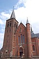 Church of Neer
 -
 Ferry across the Maas
 -
 Former beer brewery
 -
 Former town hall


References edit
- ^ a b c "Kerncijfers wijken en buurten 2021". Central Bureau of Statistics. Retrieved 24 April 2022.
- ^ "Postcodetool for 6086AA". Actueel Hoogtebestand Nederland (in Dutch). Het Waterschapshuis. Retrieved 24 April 2022.
- ^ "Neer - (geografische naam)". Etymologiebank (in Dutch). Retrieved 24 April 2022.
- ^ a b Sabine Broekhoven, & Ronald Stenvert (2003). Neer (in Dutch). Zwolle: Waanders. ISBN 90 400 9623 6. Retrieved 24 April 2022.
- ^ "Friedesse Molen". Molen database (in Dutch). Retrieved 24 April 2022.
- ^ a b "Neer". Plaatsengids (in Dutch). Retrieved 24 April 2022.
- ^ Ad van der Meer and Onno Boonstra, Repertorium van Nederlandse gemeenten, KNAW, 2011.