
KNOWPIA
WELCOME TO KNOWPIA

Neils Island 
Summary
Neils Island (sometimes called Neil Island)[1] is a former island in Sonoma County, California,[2] close to (and formerly surrounded by wetlands of) the Petaluma River, upstream of San Pablo Bay (an embayment of San Francisco Bay).[3][4][5][6][7][8][9][10] Its coordinates are 38°11′27″N 122°34′41″W / 38.19083°N 122.57806°W[1], and the United States Geological Survey measured its elevation as 82 ft (25 m) in 1981.[1] It appears in a 1954 USGS map of the region.[11]
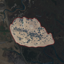 USGS aerial imagery of Neils Island | |
 Neils Island  Neils Island  Neils Island | |
| Geography | |
|---|---|
| Location | Northern California |
| Coordinates | 38°11′27″N 122°34′41″W / 38.19083°N 122.57806°W[1] |
| Adjacent to | Petaluma River |
| Highest elevation | 82 ft (25 m)[1] |
| Administration | |
United States | |
| State | |
| County | Sonoma |

References edit
- ^ a b c d e U.S. Geological Survey Geographic Names Information System: Neils Island
- ^ Gregory, Tom (1911). History of Sonoma County, California: With Biographical Sketches of the Leading Men and Women of the County, who Have Been Identified with Its Growth and Development from the Early Days to the Present Time. Historic Record Company. p. 988.
- ^ "A Leonine Epicure". The San Francisco Call. San Francisco, California. 1892-08-26. p. 2.
- ^ "A Strange Capture". Petaluma Daily Morning Courier. Petaluma, California. 1897-02-24. p. 1.
- ^ "Briefs". Petaluma Daily Morning Courier. Petaluma, California. 1907-06-07. p. 2.
- ^ "Ducks and Geese Scarce on the Popular Marshes". The San Francisco Call. San Francisco, California. 1909-12-19. p. 25.
- ^ "People You Know". Petaluma Daily Morning Courier. Petaluma, California. 1918-01-05. p. 5.
- ^ "Reporter's Notebook". Daily Independent Journal. San Rafael, California. 1958-03-15. p. 4.
- ^ "River". Daily Independent Journal. San Rafael, California. 1970-04-10. p. 4.
- ^ "River Paddle offered this Saturday". Petaluma Argus-Courier. Petaluma, California. 2003-02-26. p. 11.
- ^ United States Geological Survey (1954). "Petaluma Quadrangle, California" (Map). United States Department of the Interior Geological Survey. 1:62500.