


Summary
Nevlunghavn or Nevlunghamn is a village in Larvik Municipality in Vestfold county, Norway. The village is located along the Skaggerak coast in the Brunlanes area of Larvik. It is located about 3 kilometres (1.9 mi) to the south of the village of Helgeroa and about 12 kilometres (7.5 mi) west of the town of Stavern.
Nevlunghavn
Nevlunghamn | |
|---|---|
Village | |
 View of the village in winter | |
 Nevlunghavn Location of the village  Nevlunghavn Nevlunghavn (Norway) | |
| Coordinates: 58°58′03″N 9°52′03″E / 58.96741°N 9.86748°E | |
| Country | Norway |
| Region | Eastern Norway |
| County | Vestfold |
| District | Vestfold |
| Municipality | Larvik Municipality |
| Elevation | 4 m (13 ft) |
| Time zone | UTC+01:00 (CET) |
| • Summer (DST) | UTC+02:00 (CEST) |
| Post Code | 3296 Nevlunghavn |
Nevlunghavn and neighboring Helgeroa have grown together through conurbation so that Statistics Norway considers them to form one urban area. The statistics about the two villages are no longer tracked separately. The 1.66-square-kilometre (410-acre) urban area has a population (2022) of 1,962 and a population density of 1,185 inhabitants per square kilometre (3,070/sq mi).[2]
Nevlunghavn is the southernmost point in Vestfold County, excluding islands, islets and skerries.[3][4] It was located in southern Brunlanes municipality until 1988 when it became part of Larvik Municipality.
Tourism edit
Nevlunghavn is located in a harbor which lies about 3 kilometres (1.9 mi) south of Helgeroa. As a former pilot station, Nevlunghavn is now a fishing village characterized by its many fishing boats and fishers bringing their catch ashore. It has managed to preserve its original character. The harbor also houses several oceanside seafood restaurants and bars, a yachting harbor, a fishing harbor, and numerous restaurants serving freshly caught seafood such as crab, fish, and shrimp.[3]
The village experiences significant summer tourism. Nearby is Oddanesand, a beach used for swimming, camping and other recreational activities.[4] Gurvika, Oddanesand, and Mølen lie immediately west of Nevlunghavn. While campsites are found at Gurvika and Oddanesand, Mølen is one of Larvik's most popular tourist attractions.[3] From the campsite it is a 90-minute hike to the Bronze Age graves at Mølen.[5] Nevlunghavn has been placed on the United Nations' list of places worthy of preservation.[6]
-
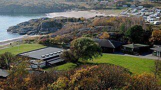 Gurvika and Oddane Sand
 -
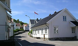 Road through Nevlunghavn
 -
 Humlesekken
 -
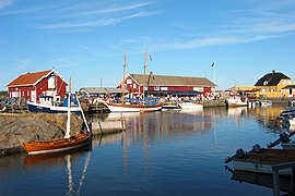 Nevlunghavn harbor
 -
 Gerhard Munthe - View of Nevlunghavn (1880)


References edit
- ^ "Nevlunghavn, Larvik". yr.no. Retrieved 4 November 2023.
- ^ Statistisk sentralbyrå (1 January 2022). "Urban settlements. Population and area, by municipality".
- ^ a b c Lund, Arild; Jørgensen, Charlotte (2001). Larvik. Capella Media. p. 67. ISBN 9788299606912.
- ^ a b Bertelsen, Hans Kristian (1998). Bli kjent med Vestfold / Become acquainted with Vestfold. Stavanger Offset AS. p. 48. ISBN 9788290636017.
- ^ Nickel, Phyllis; Valderhaug, Hans Jakob (2017). Norwegian Cruising Guide—Vol 2: Sweden, West Coast and Norway, Swedish Border to Bergen. Attainable Adventure Cruising Ltd. p. 100. ISBN 9780995893962.
- ^ "Bakkane Gård – +47 33 19 13 41". www.bakkane-gaard.no. Archived from the original on 17 June 2018.