


Summary
Route 35 is a state highway in the U.S. state of New Jersey, primarily traveling through the easternmost parts of Middlesex, Monmouth, and Ocean counties. It runs 58.11 mi (93.52 km) from the entrance to Island Beach State Park in Berkeley Township, Ocean County to an intersection with Route 27 in Rahway, Union County. Between Seaside Park and Mantoloking, Route 35 follows the right-of-way of the former Pennsylvania Railroad along the Jersey Shore. The route heads through Point Pleasant Beach and crosses the Manasquan River on the Brielle Bridge, meeting Route 34 and Route 70 at the former Brielle Circle in Wall Township. From there, Route 35 heads north and intersects Route 138, an extension of Interstate 195, continuing north through Monmouth County before crossing the Victory Bridge over the Raritan River into Perth Amboy, where the route continues north to Rahway.
Route 35 | ||||
|---|---|---|---|---|
 Route 35 highlighted in red | ||||
| Route information | ||||
| Maintained by NJDOT | ||||
| Length | 58.11 mi[1] (93.52 km) | |||
| Existed | 1927–present | |||
| Major junctions | ||||
| South end | Island Beach State Park in Berkeley Township | |||
| ||||
| North end | ||||
| Location | ||||
| Country | United States | |||
| State | New Jersey | |||
| Counties | Ocean, Monmouth, Middlesex, Union | |||
| Highway system | ||||
| ||||

Route 35 was designated in 1927 to run from Lakewood to South Amboy, from Lakewood to Belmar and from Eatontown to South Amboy. It was realigned onto its current alignment between Brielle and Belmar in 1929 and saw a northward extension along U.S. Route 9 from South Amboy to Iselin in 1947. In 1953, Route 35 was realigned to run from Point Pleasant to Seaside Heights along a former part of Route 37, with Route 35 between Lakewood and Point Pleasant becoming Route 88. At the same time, Route 35 was removed from U.S. Route 9 between South Amboy and Iselin and realigned to follow a former piece of Route 4 between South Amboy and Rahway. From the late 1950s to the mid-1970s, there were plans to build a freeway along the Route 35 corridor from Seaside Heights north into Monmouth County; the only portion that was built became part of Route 18. Route 35 was extended south to the Island Beach State Park entrance by the 1980s. Recent improvements to the route have removed many traffic circles and replaced the first cloverleaf interchange in the United States, built in 1929, at U.S. Route 1/9 in Woodbridge Township with a partial cloverleaf interchange.
Route description edit
Ocean County edit
Route 35 begins at the entrance to Island Beach State Park in Berkeley Township, Ocean County at the southern tip of the Barnegat Peninsula. South of Seaside Park, Route 35 is Central Avenue as it is the only road while it travels along the shore of the Peninsula. It heads north, varying between a two-lane road to a four-lane divided highway with parking spaces in the median and bike lanes on the outside through residential areas of South Seaside Park.[2] It briefly becomes an undivided highway before crossing into Seaside Park, where the route becomes four-lane, divided Central Avenue, which also has median parking spaces. Route 35 passes by residences in Seaside Park, with the median widening for the Seaside Park Police Department building at the Sixth Avenue intersection, and then the road widening to six lanes further north.[1][2] Upon crossing Decatur Street, the southbound lanes of Route 35 run one block to the west of the northbound lanes and then turns to the west, crossing into Seaside Heights, a beach resort that has a boardwalk and an amusement pier. In Seaside Heights, Route 35 turns north and has an interchange with the eastern terminus of Route 37 on the Seaside Heights/Berkeley Township border on the eastern shore of Barnegat Bay. At this interchange, a ramp provides access from northbound Route 35 a short distance past the ramp from eastbound Route 37 to Seaside Heights, connecting to Sumner Avenue.[1][3]

Past the Route 37 interchange, Route 35 continues north along Barnegat Bay, curving eastward and crossing into Toms River Township, where the route splits into a block-wide one-way pair with two lanes and a bike lane in each direction that heads north through residential and commercial Ortley Beach. After crossing into Lavallette a mile later, the northbound direction of Route 35 becomes Grand Central Avenue and the southbound direction of Route 35 becomes Anna O. Hawkins Boulevard.[1][3] The route then crosses back into Toms River Township, passing through Dover Beaches North. When Route 35 enters Brick Township, the northbound direction becomes Ocean Avenue and the one-way pair between the opposing directions of Route 35 narrows as it passes oceanfront residences.[2] Upon crossing into Mantoloking, Route 35 becomes a two-lane, undivided road and heads north along a narrow peninsula, intersecting the eastern terminus of County Route 528 (Herbert Street) less than a mile later.[1]
Route 35 continues north through Bay Head, where the bike lanes end and the road name becomes Main Avenue. It then enters Point Pleasant Beach, a beach resort with a boardwalk, where the route swings to the west and crosses NJ Transit's North Jersey Coast Line. Southbound Route 35 intersects the eastern terminus of Route 88 before Route 35 turns north onto another one-way pair with two lanes in each direction—the northbound direction following Cincinnati Avenue and the southbound direction following Richmond Avenue.[3] The one-way pair carries the route through the downtown area of Point Pleasant Beach, with the NJ Transit tracks parallel to the east.[2] At the County Route 633 (Arnold Avenue) intersection, northbound Route 35 shifts slightly to the west and becomes Hawthorne Avenue, passing to the west of the Point Pleasant Beach station serving the North Jersey Coast Line. The route becomes a two-way highway again after half a mile and becomes a four-lane divided highway after intersecting County Route 635 (Broadway), almost immediately crossing a channel of the Manasquan River and entering Monmouth County.[1]
Monmouth County edit

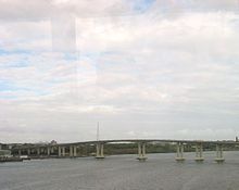
Route 35 crosses into Brielle, Monmouth County, immediately passing over the main channel of the Manasquan River on a drawbridge. Upon crossing into Brielle, the route heads further west from the railroad tracks and interchanges with Ashley Avenue and the southern terminus of Route 71. The route continues northwest and crosses into Wall Township and meets Route 34 and Route 70 at the former Brielle Circle, now an at-grade intersection with jughandles. Past this intersection, Route 35 heads north on a two-lane, undivided road that passes by many businesses. It meets County Route 524 Spur at the Manasquan Circle, where the Circle Factory Outlet Center is located. Past the Manasquan Circle, Route 35 heads north as a three-lane road with a center left-turn lane that intersects County Route 524 (Allaire Road).[1][2] Route 35 widens to a four-lane divided highway and interchanges with the eastern terminus of Route 138, which continues west to become Interstate 195. Route 35 curves to the east and crosses into Belmar. Here, the route runs along the south bank of the Shark River as a four-lane undivided highway, intersecting Route 71 again and forming a concurrency with that route. The two routes continue north along a divided highway until the intersection with 8th Avenue, where Route 71 heads to the east. Past this intersection, Route 35 becomes a four-lane, undivided road again, with the North Jersey Coast Line east of the road, and crosses the Shark River into Neptune Township.[1]

Past the Shark River bridge, Route 35 continues as a four-lane divided highway that features an interchange with County Route 40A (Memorial Drive), crossing into Neptune City. The route continues northwest away from the railroad tracks through residential and commercial areas of Neptune City as a four-lane, undivided highway before heading north as a two-lane, undivided road.[2] Route 35 crosses back into Neptune Township, where it crosses Route 33.[1] It continues through suburban development and comes to the Asbury Park Circle where the route intersects County Route 16 (Asbury Avenue), crosses into Ocean Township, and intersects the eastern terminus of Route 66. The route becomes a four-lane divided highway and passes by the Seaview Square Shopping Center as it continues north through commercial areas, intersecting many roads with jughandles and passing near Weltz County Park. Route 35 passes through the intersection of Talmadge Avenue.[1][2]

Route 35 then enters Eatontown, where it passes by the Monmouth Mall and intersects Route 36 at the former Eatontown Circle, now an at-grade intersection with ramps.[1][2] After that intersection, the route becomes an undivided highway, turning into Main Street. Consequently, Route 35 passes through a few more roads and commercial areas before finally crossing County Route 547 (Wyckoff Road), where it becomes Broad Street. Past this intersection, Route 35 intersects the northern terminus of Route 71. The route has a junction with County Route 537 (Tinton Avenue/Avenue of Memories) adjacent to the former entrance to Fort Monmouth. Route 35 crosses into Shrewsbury and continues north through residential and commercial areas, passing by The Grove at Shrewsbury.[1] It intersects County Route 520 (Newman Springs Road), running concurrent with that route and immediately crossing the North Jersey Coast Line into Red Bank. Upon entering Red Bank, County Route 520, along with County Route 11, head north on Broad Street and Route 35 heads northwest on two-lane Maple Avenue, which turns north and passes by numerous homes.[2] Route 35 splits from Maple Avenue and rejoins on four-lane Riverside Avenue, where it heads northwest and then crosses the Navesink River into Middletown Township.[1]
Past the Navesink River, the route runs along a four-lane, divided highway with a jersey barrier, passing through commercial areas. It crosses under Normandy Road, which serves as a road and railroad link between the two sections of Naval Weapons Station Earle.[1] Along the northbound lanes of Route 35, just before the intersection of Kings Highway, stands the Evil Clown of Middletown, a large sign advertising a liquor store. A mixed-use complex, the Middletown Town Center, is also planned to be built in this area. The route intersects County Route 516 (Cherry Tree Farm Road), running concurrent with that route as it enters Holmdel Township. The concurrency with County Route 516 ends at the intersection with South Laurel Avenue, where that route heads to the north and County Route 52 heads to the south on South Laurel Avenue. Route 35 continues west past numerous businesses and runs through Hazlet before crossing into Keyport. In Keyport, the route comes to an interchange with the northern terminus of Route 36 that also features access to the Garden State Parkway. Past this interchange, the road continues northwest and passes under the Henry Hudson Trail before it intersects the northern terminus of County Route 3, where it also features ramps to County Route 516, which Route 35 passes under just to the north. Past this interchange, the road crosses the Matawan Creek into Aberdeen Township, where it heads northwest through Cliffwood Beach.[1][2]
Middlesex and Union counties edit
Route 35 crosses the Whale Creek into Old Bridge Township, Middlesex County, where it continues northwest through businesses and residences in Laurence Harbor and Cliffwood Beach, both sections of Old Bridge Township. It crosses the Cheesequake Creek on a drawbridge into Sayreville and turns to the west, passing over the North Jersey Coast Line. The road then interchanges with Pine Avenue, which provides access to County Route 615 (Bordentown Avenue).[1] Past this interchange, the route turns north and crosses into South Amboy, where Route 35 comes to an interchange and forms a concurrency with U.S. Route 9. The two routes head through commercial areas and woodland, crossing over Conrail Shared Assets Operations' (CSAO) Amboy Secondary before interchanging with CR 535 (Raritan Street) and Kearney Road, crossing back into Sayreville at the interchange with the former. U.S. Route 9 and Route 35 split at an interchange (the former Victory Circle) that features access to the southbound Garden State Parkway by way of Chevalier Avenue, with Route 35 continuing north on a four-lane divided highway that passes through marshland and crosses the Raritan River on the Victory Bridge into Perth Amboy. In Perth Amboy, the route becomes four-lane, undivided Convery Boulevard upon crossing County Route 656 (Smith Street).[1][2]

The route continues north through commercial and residential sections of Perth Amboy, crossing over a connector to the Route 440 freeway and CSAO's Perth Amboy Running Track line. It intersects the eastbound direction of Route 184, the former alignment of Route 440, before meeting Route 440 (also an unsigned part of County Route 501) at an interchange. Route 35 intersects the westbound direction of Route 184 and heads north, crossing into Woodbridge Township, where it becomes Amboy Avenue.[1][2] In Woodbridge Township, the route passes by William Warren County Park and crosses over the New Jersey Turnpike (Interstate 95). Past the New Jersey Turnpike, the road heads into residential neighborhoods, crossing County Route 514 (Main Street). Route 35 merges onto St. Georges Avenue and crosses CSAO's Port Reading Secondary line before it comes to a partial cloverleaf interchange with U.S. Route 1/9. Past U.S. Route 1/9, the road passes homes and businesses, heading into Rahway, Union County just before crossing the Rahway River. Upon entering Rahway, Route 35 crosses under Amtrak's Northeast Corridor rail line just before ending at Route 27. Route 27 continues north on St. Georges Avenue past the terminus of Route 35.[1][2]
History edit

The present-day alignment of Route 35 follows parts of many 19th-century turnpikes, including the Middletown Turnpike, chartered in 1866 to run from Middletown Township to Red Bank, the Middletown and Keyport Turnpike, which was chartered on March 15, 1859 to run from Middletown Township to Keyport, and the Red Bank and Eatontown Turnpike, chartered on February 9, 1865 along present-day Broad Street, County Route 11, and Route 35.[4] The road running from Perth Amboy to Keyport, and from Point Pleasant to Seaside Heights, was signed as part of the Jersey Coast Way, running from the Staten Island Ferry to Cape May.[5]
In 1916, the current alignment of Route 35 was legislated as a part of pre-1927 Route 4 between Point Pleasant and Brielle and from Eatontown to South Amboy.[6] In the 1927 New Jersey state highway renumbering, Route 35 was designated to run from Lakewood to South Amboy, replacing pre-1927 Route 4 from Lakewood to Belmar and from Eatontown to South Amboy with the portion of pre-1927 Route 4 between Belmar and Eatontown becoming Route 4N (now Route 71).[7][8] At this time, U.S. Route 9 followed the portions of Route 35 that were formerly a part of pre-1927 Route 4.[9]
By the 1940s, Route 35 was designated onto its current alignment between Brielle and Belmar with the former alignment becoming a southern extension of Route 4N. U.S. Route 9 was also moved off of Route 35 onto a newly completed alignment of Route 4 between Lakewood and South Amboy.[10] In 1947, Route 35 was extended north to end at Route 25 (now U.S. Route 1) in Iselin, running concurrent with U.S. Route 9.[11] The current bridge over the Manasquan River and the bypass of Brielle were opened in 1951.[12]
In the 1953 New Jersey state highway renumbering, the portion of Route 35 between Lakewood and Point Pleasant became Route 88 and Route 35 was designated to head south from Point Pleasant to Seaside Heights on what had been a part of Route 37.[13] This section of Route 35 follows the right-of-way of the former Pennsylvania Railroad between Seaside Park and Mantoloking, which was removed in 1949.[14] Also in the 1953 renumbering, the Route 35 designation was removed from the concurrency with U.S. Route 9 between South Amboy and Iselin and reassigned to the former alignment of Route 4 between South Amboy and Route 27 in Rahway.
In the late 1950s, plans were made for a freeway along the Route 35 corridor between Seaside Heights and Long Branch to reduce congestion along the current route.[15] This proposed freeway was built as Route 18 between Wall Township and Eatontown from 1965 to 1991 while the southern portion to Seaside Heights was never built. In the early 1970s, a Route 35 freeway was planned to run from Route 18 north to the planned Route 74 freeway in Matawan with an estimated cost of $53 million. This freeway was never built due to the cancellation of the Route 74 freeway in the mid-1970s.[16]


Since the 1953 renumbering, the current alignment of Route 35 has seen many changes and improvements. The current interchange with Route 37 and the bypass around Seaside Heights were completed in 1958.[17] The highway was turned into a one-way pair between Brick and Seaside Heights in 1961 by utilizing the former right-of-way of the Pennsylvania Railroad.[18] The section of the route through downtown Point Pleasant Beach was turned into a one-way pair in 1967.[19] Route 35 was extended south to the entrance of Island Beach State Park by the 1980s.[20] Many traffic circles have been removed along Route 35 in recent years, including the Brielle Circle in 2001 and the Eatontown Circle, which were both converted into at-grade intersections with traffic lights, and the Victory Circle, which was replaced with an interchange between 2003 and 2006.[21][22] Between 2002 and 2005, the Victory Bridge over the Raritan River was reconstructed at a cost of $109 million.[23] Between February 2006 and November 2008, the Woodbridge Cloverleaf interchange with U.S. Route 1/9 in Woodbridge Township, first cloverleaf interchange in the United States built in 1929 when this portion of Route 35 was still a part of Route 4, was replaced with a partial cloverleaf interchange, costing $34 million.[24][25][26]
On February 1, 2013, Route 35 through Mantoloking was fully reopened after being closed since October 29, 2012 after Hurricane Sandy hit the area. The night of the storm at the intersection where the Mantoloking Bridge and Route 35 meet, a new inlet was formed by the raging storm waters. This effectively cut off the island from the mainland.[27]
Beginning in March 2013 (after a 6-month delay due to Hurricane Sandy), a four-year major construction project began on Route 35 between Raritan Blvd in Cliffwood Beach (Old Bridge) and Amboy Avenue in Aberdeen. The project includes several highway improvements designed to alleviate the flooding the highway is prone to due to its lowness and being adjacent in several areas to tidal marshes and Whale Creek and Long Neck Creek, widening of four intersections (Birchwood Drive, County Road, Cliffwood Avenue, and Amboy Avenue), and lane alignments, and additions for pedestrian and bicyclist safety. Also planned are traffic signal upgrades to reduce congestion. The project was expected to be completed in 2015.[28]
Major intersections edit
| County | Location | mi[1] | km | Destinations | Notes |
|---|---|---|---|---|---|
| Ocean | Berkeley Township | 0.00 | 0.00 | Entrance of Island Beach State Park | |
| Berkeley Township–Seaside Heights line | 2.70 | 4.35 | Interchange; eastern terminus of Route 37 | ||
| 2.70 | 4.35 | Seaside Heights | Northbound exit; access via Sumner Avenue | ||
| Mantoloking | 9.94 | 16.00 | Eastern terminus of CR 528 | ||
| Point Pleasant Beach | 12.92 | 20.79 | Eastern terminus of Route 88 | ||
| Monmouth | Brielle | 14.80 | 23.82 | Ashley Avenue – Brielle Business Center | Interchange |
| 15.12 | 24.33 | Interchange; southern terminus of Route 71 | |||
| Wall Township | 15.97 | 25.70 | Former Brielle Circle; southern terminus of Route 34, eastern terminus of Route 70 | ||
| 17.17 | 27.63 | Manasquan Circle; access to Manasquan station | |||
| 18.78 | 30.22 | ||||
| 20.21 | 32.52 | Interchange; eastern terminus of Route 138 | |||
| Belmar | 21.06 | 33.89 | South end of the overlap with Route 71 | ||
| 21.41 | 34.46 | North end of the overlap with Route 71 | |||
| Neptune Township | 21.96 | 35.34 | Bradley Beach, Avon | Interchange; access via CR 40A / CR 17 | |
| 23.45 | 37.74 | ||||
| Ocean Township | 24.81 | 39.93 | Asbury Park Circle; eastern terminus of Route 66 | ||
| Eatontown | 29.39 | 47.30 | Former Eatontown Circle | ||
| 29.65 | 47.72 | ||||
| 30.44 | 48.99 | Northern terminus of Route 71 | |||
| 30.66 | 49.34 | ||||
| Shrewsbury | 32.87 | 52.90 | South end of the overlap with CR 520 | ||
| Red Bank | 32.91 | 52.96 | North end of the overlap with CR 520 | ||
| Middletown Township | 39.43 | 63.46 | Taylor Lane – Heritage at Middletown | South end of the overlap with CR 516 | |
| Holmdel Township | 39.84 | 64.12 | North end of the overlap with CR 516 | ||
| Keyport | 43.16 | 69.46 | Interchange, Exit 117 (Garden State Parkway), no access from Route 36 to Route 35 southbound or from Route 35 northbound to Route 36 | ||
| 43.82 | 70.52 | Interchange | |||
| Middlesex | Sayreville | 48.08 | 77.38 | To Bordentown Avenue - South Amboy | Interchange |
| South Amboy | 49.38 | 79.47 | Interchange; south end of the overlap with US 9 | ||
| 50.02 | 80.50 | Interchange | |||
| Sayreville | 50.49 | 81.26 | Kearney Road | Interchange | |
| 50.63 | 81.48 | Interchange; north end of the overlap with US 9, Exit 125 (Garden State Parkway) | |||
| Raritan River | 51.75 | 83.28 | Victory Bridge | ||
| Perth Amboy | 53.23 | 85.67 | Eastbound direction and eastern terminus of Route 184 | ||
| 53.32 | 85.81 | Interchange | |||
| 53.39 | 85.92 | Westbound direction and eastern terminus of Route 184 | |||
| Woodbridge Township | 55.08 | 88.64 | |||
| 56.48 | 90.90 | Interchange | |||
| Union | Rahway | 58.07 | 93.45 | ||
1.000 mi = 1.609 km; 1.000 km = 0.621 mi
| |||||
See also edit
 U.S. Roads portal
 New Jersey portal
References edit
- ^ a b c d e f g h i j k l m n o p q r s t "Route 35 straight line diagram" (PDF). New Jersey Department of Transportation. Retrieved March 17, 2020.
- ^ a b c d e f g h i j k l m Google (December 17, 2008). "overview of New Jersey Route 35" (Map). Google Maps. Google. Retrieved December 17, 2008.
- ^ a b c "Route 35 Z straight line diagram" (PDF). New Jersey Department of Transportation. Retrieved December 17, 2008.
- ^ Murphy, John L. (1877). Index of Colonial and State Laws Between the Years 1663 and 1877 Inclusive. Retrieved January 13, 2009.
- ^ Rand McNally and Co. "Eastern Ohio, Western Pennsylvania, South East Michigan, Southern Ontario, Western New York: District No. 4". Rand McNally Official Auto Trails Map, 3rd ed., 1924, pp. 168-169. David Rumsey Historical Map Collection, David Rumsey (curator), Cartography Associates, Accessed Nov 4, 2019, www.davidrumsey.com/luna/servlet/detail/RUMSEY~8~1~201570~3000600:Auto-Trails-Map--Pennsylvania,-New-.
- ^ Annual Report. New Jersey State Highway Department. 1916.
- ^ State of New Jersey, Laws of 1927, Chapter 319.
- ^ 1927 New Jersey Road Map (Map). State of New Jersey. Archived from the original on October 31, 2007. Retrieved October 8, 2008.
- ^ Map of New Jersey (Map). Tydol Trails. 1927. Archived from the original on May 14, 2011. Retrieved February 9, 2011.
- ^ Map of Pennsylvania and New Jersey (Map). Cartography by H.M. Gousha. Mid-West Map Co. 1941. Retrieved March 29, 2009.
- ^ State of New Jersey, Laws of 1947, Chapter 328.
- ^ "Governor Dedicates Span Linking Shore Counties". Asbury Park Press. May 26, 1951 – via Newspapers.com.
- ^ "1953 renumbering". New Jersey Department of Highways. Archived from the original on June 28, 2011. Retrieved July 31, 2009.
{{cite journal}}: Cite journal requires|journal=(help) - ^ "History". Borough of Seaside Park. Retrieved September 10, 2013.
- ^ Regional Highways: Status Report. Tri-State Transportation Commission. 1962.
- ^ Master Plan for Transportation. New Jersey Department of Transportation. 1972.
- ^ "New Seaside Heights Approach to Open". The News (Paterson, NJ). Associated Press. December 5, 1958 – via Newspapers.com.
- ^ "Rte. 35 Work Nearly Done". Asbury Park Press. October 8, 1961 – via Newspapers.com.
- ^ "2-Lane Traffic Ensnarls Shore". Asbury Park Press. August 7, 1967 – via Newspapers.com.
- ^ State Farm Road Atlas (Map). Cartography by Rand McNally. State Farm Insurance. 1983.
- ^ "DiFrancesco and Weinstein Open Newly Reconfigured Interchange". New Jersey Department of Transportation. Retrieved December 21, 2008.
- ^ "Route 9 and 35 Victory Circle Elimination Project: Frequently Asked Questions". New Jersey Department of Transportation. Retrieved April 7, 2007.
- ^ "Route 35 Victory Bridge Overview, Construction Updates, Commuter Information". New Jersey Department of Transportation. Retrieved December 21, 2008.
- ^ "Routes 1&9-35 Interchange Improvements, Project Description, Construction Updates, Commuter Information". New Jersey Department of Transportation. Retrieved December 21, 2008.
- ^ "The Cloverleaf Interchange". WhereRoadsMeet. Archived from the original on May 14, 2008. Retrieved December 21, 2008.
- ^ MartÃn, Hugo (April 7, 2004). "A Major Lane Change". Los Angeles Times. Retrieved December 21, 2008.
- ^ "Route 35 Through Hurricane-Ravaged Mantoloking To Fully Reopen Friday". CBS News New York. Retrieved February 1, 2013.
- ^ "NJDOT announces Route 35 improvements in Aberdeen and Old Bridge". NJ DOT. Retrieved November 15, 2013.
External links edit
- New Jersey Roads: Route 35
- Unbuilt Route 35 Freeway
- Speed Limits for Route 35