
KNOWPIA
WELCOME TO KNOWPIA

Ngatangiia 
Summary
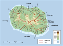
Ngatangiia is one of the five districts that make up the island of Rarotonga in the Cook Islands.[1] It is located in the east of the island, to the south of the districts of Matavera and Avarua, and northeast of the district of Titikaveka.

References edit
- ^ "Official Map of Rarotonga". Cook Islands Ministry of Justice. Retrieved 10 August 2020.
21°15′0.91″S 159°44′16.19″W / 21.2502528°S 159.7378306°W