


Summary
Niederanven (Luxembourgish: Nidderaanwen [nidəˈʀaːnvən] ⓘ; German: Niederanwen) is a commune Luxembourg, located north-east of Luxembourg City, and derives its name from principal town, Niederanven. As of 2023[update], it has a population of 6,660.
Niederanven
Nidderaanwen | |
|---|---|
 | |
 Coat of arms | |
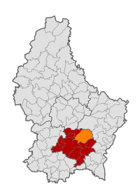 Map of Luxembourg with Niederanven highlighted in orange, and the canton in dark red | |
| Coordinates: 49°39′05″N 6°15′20″E / 49.6514°N 6.2556°E | |
| Country | |
| Canton | Luxembourg |
| Area | |
| • Total | 41.36 km2 (15.97 sq mi) |
| • Rank | 12th of 100 |
| Highest elevation | 429 m (1,407 ft) |
| • Rank | 28th of 100 |
| Lowest elevation | 241 m (791 ft) |
| • Rank | 47th of 100 |
| Population (2023) | |
| • Total | 6,660 |
| • Rank | 23rd of 100 |
| • Density | 160/km2 (420/sq mi) |
| • Rank | 21st of 100 |
| Time zone | UTC+1 (CET) |
| • Summer (DST) | UTC+2 (CEST) |
| LAU 2 | LU0000305 |
| Website | niederanven.lu |
The commune of Niederanven is the intersection for the A1 motorway and N1. Luxembourg Airport is located within the boundaries of the communes Niederanven and Sandweiler.
Geography edit
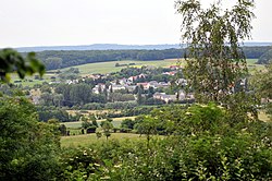
As of 2024[update], the town of Niederanven, which lies in the north-east of the commune, has a population of 1,537.[1] Other towns within the commune include Ernster, Hostert, Oberanven, Rameldange, Senningen and Senningerberg, as well as the hamlet of Waldhof.
Population edit
Twin towns — sister cities edit
Niederanven is a founding member of the Douzelage, a town twinning association of towns across the European Union. This active town twinning began in 1991 and there are regular events, such as a produce market from each of the other countries and festivals. As of 2019, its members are:[3]
 Agros, Cyprus
 Altea, Spain
 Asikkala, Finland
 Bad Kötzting, Germany
 Bellagio, Italy
 Bundoran, Ireland
 Chojna, Poland
 Granville, France
 Holstebro, Denmark
 Houffalize, Belgium
 Judenburg, Austria
 Kőszeg, Hungary
 Marsaskala, Malta
 Meerssen, Netherlands
 Oxelösund, Sweden
 Preveza, Greece
 Rokiškis, Lithuania
 Rovinj, Croatia
 Sesimbra, Portugal
 Sherborne, England, United Kingdom
 Sigulda, Latvia
 Siret, Romania
 Škofja Loka, Slovenia
 Sušice, Czech Republic
 Tryavna, Bulgaria
 Türi, Estonia
 Zvolen, Slovakia
Notable people edit
- Émile Speller (1875–1952), a Luxembourgish military officer and the commander of the country's Gendarmes and Volunteers Corps
- Jeng Kirchen (1919 in Hostert – 2010), a Luxembourgish road racing cyclist
References edit
External links edit
 Media related to Niederanven at Wikimedia Commons