
KNOWPIA
WELCOME TO KNOWPIA

Nieuwerbrug 
Summary
Nieuwerbrug (also Nieuwerbrug aan de Rijn) is a village in the Dutch province of South Holland. It is a part of the former municipality of Bodegraven, and lies about five kilometres west of Woerden. Bodegraven has become part of the municipality of Bodegraven-Reeuwijk in 2011. Nieuwerbrug aan de Rijn is the spelling since 2009 to distinguish from Nieuwebrug in Friesland.[3]
Nieuwerbrug
Nieuwerbrug aan de Rijn | |
|---|---|
Village | |
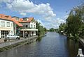
 Centre of Nieuwerbrug with the church and toll bridge | |
 Nieuwerbrug Location in the province of South Holland in the Netherlands  Nieuwerbrug Location in the Netherlands | |
| Coordinates: 52°4′37″N 4°48′56″E / 52.07694°N 4.81556°E | |
| Country | Netherlands |
| Province | South Holland |
| Municipality | Bodegraven-Reeuwijk |
| Area | |
| • Total | 12.02 km2 (4.64 sq mi) |
| Elevation | 0.3 m (1.0 ft) |
| Population (2021)[1] | |
| • Total | 1,790 |
| • Density | 150/km2 (390/sq mi) |
| Time zone | UTC+1 (CET) |
| • Summer (DST) | UTC+2 (CEST) |
| Postal code | 2415[1] |
| Dialing code | 0348 |
Nieuwerbrug is a dike village which developed along the bridge over the Oude Rijn which was built in 1510. The bridge became a toll bridge from 1651 to the present. A little tower was built next to the bridge between 1913 and 1914.[4]
Gallery edit
-
 View from the bridge
 -
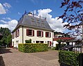 Villa Weijpoort
 -
 De Volharding


References edit
- ^ a b c "Kerncijfers wijken en buurten 2021". Central Bureau of Statistics. Retrieved 2 May 2022.
- ^ "Postcodetool for 2415AA". Actueel Hoogtebestand Nederland (in Dutch). Het Waterschapshuis. 24 July 2019. Retrieved 2 May 2022.
- ^ "Nieuwerbrug aan de Rijn". Plaatsengids (in Dutch). Retrieved 2 May 2022.
- ^ Ronald Stenvert & Sabine Broekhoven (2004). "Nieuwerbrug" (in Dutch). Zwolle: Waanders. ISBN 90-400-9034-3. Retrieved 2 May 2022.