


Summary
Nilosyrtis Mensae is an area of Mars in the Casius quadrangle. It is centered on the coordinates of 36.87° N and 67.9° E. Its western and eastern longitudes are 51.1° E and 74.4° E. North and south latitudes are 36.87° N and 29.61° N.[2] Nilosyrtis Mensae is just to the east of Protonilus Mensae and both lie along the Martian dichotomy boundary. Its name was adapted by the IAU in 1973. It was named after a classical albedo feature, and it is 705 km (438 mi) across.
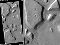 Astapus Colles Mounds and Knobs, as seen by HiRISE. Scale bar is 500 meters long. | |
| Coordinates | 36°52′N 67°54′E / 36.87°N 67.9°E |
|---|---|
| Dimensions | 705 km across |
| Naming | a classical albedo feature |

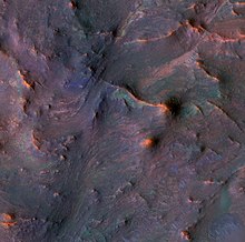
The surface of Nilosyrtis Mensae is classified as fretted terrain. This terrain contains cliffs, mesas, and wide flat valleys. Surface features are believed to have been caused by debris-covered glaciers.[3][4] These glaciers are termed lobate debris aprons when surrounding mounds and mesas.[5][6][7][8] When the glaciers are in the valleys they are called lineated valley fill.[9][10][11][12]
Climate change caused ice-rich features edit
For decades many features on Mars, including ones in Nilosyrtis Mensae, were believed to contain large amounts of ice. This idea was confirmed by radar studies with the SHAllow RADar (SHARAD) on the Mars Reconnaissance Orbiter. It showed that lobate debris aprons (LDA) and lineated valley fill (LVF) contain pure water ice covered with a thin layer of rocks that insulated the ice.[13][14] Ice was found in many locations in the northern hemisphere, including Nilosyrtis Mensae.[15] The most popular model for the origin of the ice is climate change from large changes in the tilt of the planet's rotational axis. At times the tilt has even been greater than 80 degrees[16][17] Large changes in the tilt explains many ice-rich features on Mars.
Studies have shown that when the tilt of Mars reaches 45 degrees from its current 25 degrees, ice is no longer stable at the poles.[18] Furthermore, at this high tilt, stores of solid carbon dioxide (dry ice) sublimate, thereby increasing the atmospheric pressure. This increased pressure allows more dust to be held in the atmosphere. Moisture in the atmosphere will fall as snow or as ice frozen onto dust grains. Calculations suggest this material will concentrate in the mid-latitudes.[19][20] General circulation models of the Martian atmosphere predict accumulations of ice-rich dust in the same areas where ice-rich features are found.[21] When the tilt begins to return to lower values, the ice sublimates (turns directly to a gas) and leaves behind a lag of dust.[22][23] The lag deposit caps the underlying material so with each cycle of high tilt levels, some ice-rich mantle remains behind.[24] Note, that the smooth surface mantle layer probably represents only relatively recent material.
See also edit
References edit
- ^ The Color Palette of Nilosyrtis Mensae at University of Arizona/HiRISE
- ^ "Nilosyrtis Mensae". Gazetteer of Planetary Nomenclature. USGS Astrogeology Research Program.
- ^ Greeley, R. and J. Guest. 1987. Geological map of the eastern equatorial region of Mars, scale 1:15,000,000. U. S. Geol. Ser. Misc. Invest. Map I-802-B, Reston, Virginia
- ^ Sharp, R. 1973. Mars Fretted and chaotic terrains. J. Geophys. Res.: 78. 4073-4083
- ^ Plaut, J. et al. 2008. Radar Evidence for Ice in Lobate Debris Aprons in the Mid-Northern Latitudes of Mars. Lunar and Planetary Science XXXIX. 2290.pdf
- ^ Carr, M. 2006. The Surface of Mars. Cambridge University Press. ISBN 978-0-521-87201-0
- ^ Squyres, S. 1978. Martian fretted terrain: Flow of erosional debrid. Icarus: 34. 600-613.
- ^ ISBN 0-8165-1257-4
- ^ Morgan, G. and J. Head III. 2009. Sinton crater, Mars: Evidence for impact into a plateau icefield and melting to produce valley networks at the Hesperian-Amazonian boundary. Icarus: 202. 39–59.
- ^ Morgan, G. et al. 2009. Lineated valley fill (LVF) and lobate debris aprons (LDA) in the Deuteronilus Mensae northern dichotomy boundary region, Mars: Constraints on the extent, age, and episodicity of Amazonian glacial events. Icarus: 202. 22–38.
- ^ Head, J., et al. 2006. Extensive valley glacier deposits in the northern mid-latitudes of Mars: Evidence for the late Amazonian obliquity-driven climate change. Earth Planet. Sci. Lett. 241. 663-671
- ^ Head, J., et al. 2006. Modification if the dichotomy boundary on Mars by Amazonian mid-latitude regional glaciation. Geophys. Res Lett. 33
- ^ Plaut, J. et al. 2008. Radar Evidence for Ice in Lobate Debris Aprons in the Mid-Northern Latitudes of Mars. Lunar and Planetary Science XXXIX. 2290.pdf
- ^ "HiRISE | Merging Lobate Debris Aprons of Deuteronilus Mensae (PSP_009535_2240)".
- ^ Plaut, J., A. Safaeinili,, J. Holt, R. Phillips, J. Head, J., R. Seu, N. Putzig, A. Frigeri. 2009. Radar evidence for ice in lobate debris aprons in the midnorthern latitudes of Mars. Geophys. Res. Lett. 36. doi:10.1029/2008GL036379.
- ^ Touma J. and J. Wisdom. 1993. The Chaotic Obliquity of Mars. Science 259, 1294-1297.
- ^ Laskar, J., A. Correia, M. Gastineau, F. Joutel, B. Levrard, and P. Robutel. 2004. Long term evolution and chaotic diffusion of the insolation quantities of Mars. Icarus 170, 343-364.
- ^ Levy, J., J. Head, D. Marchant, D. Kowalewski. 2008. Identification of sublimation-type thermal contraction crack polygons at the proposed NASA Phoenix landing site: Implications for substrate properties and climate-driven morphological evolution. Geophys. Res. Lett. 35. doi:10.1029/2007GL032813.
- ^ Levy, J., J. Head, D. Marchant. 2009a. Thermal contraction crack polygons on Mars: Classification, distribution, and climate implications from HiRISE observations. J. Geophys. Res. 114. doi:10.1029/2008JE003273.
- ^ Hauber, E., D. Reiss, M. Ulrich, F. Preusker, F. Trauthan, M. Zanetti, H. Hiesinger, R. Jaumann, L. Johansson, A. Johnsson, S. Van Gaselt, M. Olvmo. 2011. Landscape evolution in Martian mid-latitude regions: insights from analogous periglacial landforms in Svalbard. In: Balme, M., A. Bargery, C. Gallagher, S. Guta (eds). Martian Geomorphology. Geological Society, London. Special Publications: 356. 111-131
- ^ Laskar, J., A. Correia, M. Gastineau, F. Joutel, B. Levrard, and P. Robutel. 2004. Long term evolution and chaotic diffusion of the insolation quantities of Mars. Icarus 170, 343-364.
- ^ Mellon, M., B. Jakosky. 1995. The distribution and behavior of Martian ground ice during past and present epochs. J. Geophys. Res. 100, 11781–11799.
- ^ Schorghofer, N., 2007. Dynamics of ice ages on Mars. Nature 449, 192–194.
- ^ Madeleine, J., F. Forget, J. Head, B. Levrard, F. Montmessin. 2007. Exploring the northern mid-latitude glaciation with a general circulation model. In: Seventh International Conference on Mars. Abstract 3096.
External links edit
- NASA Astronomy Picture of the Day: Mars in the New Year (6 January 2000)
 Media related to Nilosyrtis Mensae at Wikimedia Commons