


Summary
The Nitra Region (Slovak: Nitriansky kraj, pronounced [ˈɲitrɪɐnski ˈkraj]; Hungarian: Nyitrai kerület) is one of the administrative regions of Slovakia. It was first established in 1923 and from 1996 exists in its present borders. It consists of seven districts (okres) and 354 municipalities, from which 16 have a town status. The economy of the region focuses more on agriculture, than in other Slovak regions. Nitra is its seat, largest city, and cultural and economic center.
Nitra Region
Nitriansky kraj | |
|---|---|
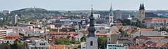
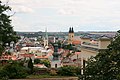
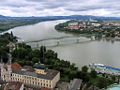
From the top to bottom-left; Panoramic view of Nitra, Komárno, Arborétum Mlyňany, Levice District Topoľčany | |
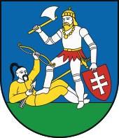
 Flag 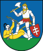 Coat of arms | |
 Nitra Region | |
| Country | |
| Capital | Nitra |
| Government | |
| • Body | County Council of Nitra Region |
| • Governor | Branislav Becík |
| Area | |
| • Total | 6,343.94 km2 (2,449.41 sq mi) |
| Highest elevation | 943 m (3,094 ft) |
| Population (2011 census) | |
| • Total | 689,867 |
| • Density | 110/km2 (280/sq mi) |
| GDP | |
| • Total | €8.801 billion (2016) |
| • Per capita | €12,925 (2016) |
| Time zone | UTC+1 (CET) |
| • Summer (DST) | UTC+2 (CEST) |
| ISO 3166 code | SK-NI |
| Website | www |


Geography edit
This region with a long history is situated in the southwest of Slovakia, mostly in the eastern part of the Danubian Lowland. It is divided into two sub-units: the Danubian Flat in the south-west, with eastern part of the Žitný ostrov island, and the Danubian Hills in the north, centre and east. Mountain ranges reaching into the region are: Považský Inovec in the north-west, where the region's highest point, Veľký Inovec, is located, Tribeč in the north from Nitra, Pohronský Inovec in the north-east and Štiavnické vrchy in the east. Major rivers are the Danube in the south, Váh in the south-west, Nitra in the western-central part, Hron in the east and Ipeľ in the south-east. As for administrative divisions, the region borders Trenčín Region in the north, Banská Bystrica Region in the east, Hungarian Pest in the south-east, Komárom-Esztergom in the south, and Győr-Moson-Sopron county in the south-west and Trnava Region in the west.
Demographics edit
| Year | Pop. | ±% |
|---|---|---|
| 1980 | 708,634 | — |
| 1991 | 716,846 | +1.2% |
| 2001 | 713,422 | −0.5% |
| 2011 | 689,867 | −3.3% |
| 2021 | 677,900 | −1.7% |
| Source:[2] | ||
The population density in the region is 106/km2 (270/sq mi) (2020-06-30/-07-01),[3] which is very similar to the country's average (110 per km2). The largest towns are Nitra, Komárno, Nové Zámky and Levice. According to the 2001 census, there were 713,422 inhabitants in the region, with a majority of Slovaks (68.3%), but there is a numerous Hungarian minority (27.6%) in the southern districts, forming a majority in the Komárno District (72%) and there are small minorities of Czechs and Roma (<1%).[4]
Economy and climate edit
The city of Nitra is also the centre of whole region. The region - which is the warmest in Slovakia - reaches a high production of wheat, rye and vegetables. Significant industries are: the food industry, with breweries in Topoľčany, Nitra and Hurbanovo, are machinery (fridges in Zlaté Moravce, shipyards in Komárno) and energy (Mochovce Nuclear Power Plant).
Politics edit
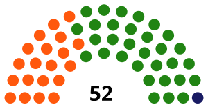
Current governor of Banská Bystrica region is Milan Belica (Smer-SD). He won with 34,1 %. In election 2017 was elected also regional parliament :
County Council of Nitra region | |
|---|---|
 | |
| Type | |
| Type | |
| Houses | County Council |
| Leadership | |
Governor | Branislav Becík, Voice |
| Structure | |
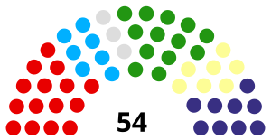
| Seats | 54 |
 | |
Political groups |
|
| Elections | |
Last election | 29 October 2022 |
| Meeting place | |
| Nitra | |
| Website | |
| Council of Nitra region | |
2017 elections edit
In governor's elections won Milan Belica (Smer–SD) over many another candidates.
 | |||||
| Political party | Seats won | +/- | Percentage | Electoral leader [6] | |
|---|---|---|---|---|---|
| Coalition led by Smer–SD[7] | 17 | 31,48 % | Jozef Dvonč | ||
| Independents | 15 | 27,77 % | Peter Oremus | ||
| SMK-MKP | 11 | 20,37 % | Miklós Viola | ||
| Centre-right coalition[8] | 10 | 18,51 % | Ján Greššo | ||
| ĽSNS | 1 | 1,85 % | Milan Uhrík | ||
2013 elections edit
In governor's elections won Milan Belica (Smer–SD) over centre-right candidate Tomáš Galbavý (SDKÚ–DS), who was supported by SaS, OKS, NOVA, Most–Híd, SMK-MKP.
 | |||||
| Parties and coalitions | % | Seats | +/- | ||
|---|---|---|---|---|---|
| Social Democrats | 35.19 | 19 | |||
| Christian Democrats | 24.07 | 13 | |||
| Smer–SD, KDH | 59.26 | 32 | |||
| SMK–MKP | 25.93 | 14 | |||
| SMK–MKP | 25.93 | 14 | |||
| Independets | 7.41 | 4 | |||
| Independets | 7.41 | 4 | |||
| SDKÚ–DS | 1.85 | 1 | |||
| Most–Híd | 1.85 | 1 | |||
| NOVA | 1.85 | 1 | |||
| SDKÚ–DS, OKS, SaS, NOVA, Most–Híd | 5.55 | 3 | |||
| Nationalists | 1.85 | 1 | |||
| SNS | 1.85 | 1 | |||
2009 elections edit
In governor's elections won Milan Belica (Smer–SD), who was supported by SDKÚ–DS and KDH.
 | |||||
| Political party | Seats won | +/- | Percentage | Electoral leader | |
|---|---|---|---|---|---|
| Smer–SD[9] | 15 | 27,78 % | Jozef Dvonč | ||
| SMK-MKP | 13 | 24,07 % | Arpád Horváth | ||
| SDKÚ–DS[10] | 9 | 16,67 % | Tibor Tóth | ||
| KDH[11] | 7 | 12,96 % | Ján Vančo | ||
| ĽS–HZDS[12] | 7 | 12,96 % | Lýdia Forrová | ||
| Independents | 3 | 5,56 % | Anton Marek | ||
2005 elections edit
In governor's elections won Milan Belica, who was supported by ASV, KSS, ĽB, ĽS–HZDS, PSNS, ZSNS. His rival in second round of elections was Ján Greššo (DS, SDKÚ).
 | |||||
| Political party | Seats won | +/- | Percentage | Electoral leader | |
|---|---|---|---|---|---|
| SMK-MKP | 17 | 32,69 % | László Fekete | ||
| Smer–SD[13] | 11 | 21,15 % | Juraj Horváth | ||
| ĽS–HZDS[14] | 10 | 19,23 % | Jozef Hasilla | ||
| KDH[15] | 7 | 13,46 % | Ján Vančo | ||
| SDKÚ[16] | 5 | 9,62 % | Tibor Tóth | ||
| SNS[17] | 1 | 1,92 % | Igor Varga | ||
| HZD | 1 | 1,92 % | Albert Hačko | ||
2001 elections edit
In governor's elections won Milan Belica, who was supported by HZDS, SOP, SDĽ and Centre party. His rival in second round of elections was Miklós Fehér (SMK-MKP).
 | ||||
| Political party | Seats won | Percentage | Electoral leader | |
|---|---|---|---|---|
| SMK-MKP | 31 | 59,62 % | Tibor Bastrnák | |
| Centre-left coalition[18] | 20 | 38,46 % | Jozef Dvonč | |
| SNS | 1 | 1,92 % | Peter Lisý | |
Administrative divisions edit
The Nitra Region consists of 7 districts. There are 354 municipalities, of which 16 are towns.
Places of interest edit
- Nitra with Nitra Castle and Saint Emmeram's Cathedral, Nitra Synagogue, Dražovce church, etc.
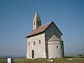
- Medieval churches in Kostoľany pod Tribečom and Nitrianska Blatnica
- Chateau and European bison sanctuary in Topoľčianky (Topoľčianska zubria zvernica)
- Šaľa - town with a castle
- The water mill and bridge in Kolárovo
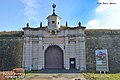
- Komárno with its fortification system, fortress, Elisabeth bridge, etc.
- Iža - Roman military camp Celemantia - UNESCO World Heritage Site
- Štúrovo - Bridge of Mária Valéria
- Levice with Levice Castle, Saint Michael's Church, Levice Town Hall etc.
- Arboretum in Tesárske Mlyňany
- Dunajské luhy Protected Landscape Area
- Ponitrie Protected Landscape Area
Photo gallery edit
-
 Topoľčany Castle
 -
-

-

-

-

-
-
 Nitrianska Blatnica church
 -
 Kostoľany pod Tribečom church
 -
 Topoľčianky chateau
 -
 European bison in Topoľčianska zubria zvernica
 -
 Šaľa castle
 -
 Water mill in Kolárovo
 -

-

-
-

-

-
-

-
 Levice Castle, Levice
 -
 Levice Town Hall, Levice
 -
 Church of Saint Michael, Levice
 -
 Arboretum Tesárske Mlyňany
 -
-


See also edit
- Nyitra County of the Kingdom of Hungary
References edit
- ^ Regions and Cities > Regional Statistics > Regional Economy > Regional GDP per Capita, OECD.Stats. Accessed on 16 November 2018.
- ^ "SLOVAKIA: Regions and Major Cities". Citypopulation. Retrieved 22 January 2021.
- ^ "Statistic of Slovak places by Dušan Kreheľ – Export". Retrieved 2021-07-05.
- ^ POPULATION AND HOUSING CENSUS 2001 - Tab. 3a
- ^ SaS, Together, Chance, ODS, DS, KDH, OKS, ZĽ, TKN
- ^ The highest number of votes in preferential voting.
- ^ Smer–SD, SNS, Most–Híd
- ^ SaS, OKS, OĽaNO, NOVA, KDH, Šanca, ZZ–DÚ
- ^ Candidated as coalition with KDH, SDKÚ–DS, ĽS–HZDS.
- ^ Candidated as coalition with KDH, Smer–SD, ĽS–HZDS.
- ^ Candidated as coalition with Smer–SD, SDKÚ–DS, ĽS–HZDS.
- ^ Candidated as coalition with KDH, Smer–SD, SDKÚ–DS.
- ^ Candidated as coalition with KDH, SDKÚ, ĽS–HZDS, SNS.
- ^ Candidated as coalition with KDH, Smer–SD, SDKÚ, SNS.
- ^ Candidated as coalition with Smer–SD, SDKÚ, ĽS–HZDS, SNS.
- ^ Candidated as coalition with KDH, Smer–SD, ĽS–HZDS, SNS.
- ^ Candidated as coalition with KDH, SDKÚ, ĽS–HZDS.
- ^ HZDS, SOP, SDĽ, Smer–SD, Centre party
- Kopa, Ľudovít; et al. (2006). The Encyclopaedia of Slovakia and the Slovaks. Bratislava, Slovakia: Encyclopaedic Institute of the Slovak Academy of Sciences. ISBN 80-224-0925-1.
External links edit
- Nitriansky samosprávny kraj Official website