


Summary
Niuland District is the 14th district of the Indian state of Nagaland. It was created on December 18, 2021. The district headquarter is located in the town of Niuland. It is tagged the "Land of diversity" being home to all Tribes of the state and a commercially potential district as it is connected to Chümoukedima, Dimapur, Kohima, Wokha and Tseminyü districts.[2]
Niuland District | |
|---|---|
| Nickname: Land of Diversity | |
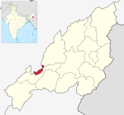 Niuland District in Nagaland | |
| Country | |
| State | Nagaland |
| Headquarters | Niuland |
| Government | |
| • Lok Sabha Constituency | Nagaland |
| • MP[1] | Tokheho Yepthomi, NDPP |
| • Deputy Commissioner | Sara S Jamir |
| • Assembly constituencies | 1 constituencies |
| Population (2011) | |
| • Total | 11,876 |
| Time zone | UTC+05:30 (IST) |
History edit
Niuland District was created on December 18, 2021 as the 14th district of Nagaland. The new district has the same boundaries as the former Niuland sub-division of Dimapur District.[3]
Geography edit
The climate is sub-tropical with a monsoon season.
Demographics edit
Most of the inhabitants of the district are Nagas, with sizable populations of Sümi, Yimkhiung and Ao Nagas along with various other Naga ethnic groups.
The total literacy rate of Niuland is 79.48%. The Child sex ratio is 1,036 which is greater than the Average Sex Ratio of 1,011.[4]
Religion edit
Religion in Niuland district (2011)
According to the 2011 census, Christianity is the religion of Niuland with 85.3% of the population.
Transportation edit
Air edit
The nearest airport is Dimapur Airport.
Rail edit
The nearest railway station is the Dimapur railway station.
See also edit
References edit
- ^ "Lok Sabha Members". Lok Sabha. Retrieved December 18, 2021.
- ^ "Niuland District Formally Inaugurated - Eastern Mirror". easternmirrornagaland.com. 2022-06-29. Retrieved 2024-03-11.
- ^ "Nagaland creates 3 more districts". The Assam Tribune. December 18, 2021. Retrieved December 18, 2021.
- ^ "Niuland Circle Population, Caste, Religion Data - Dimapur district, Nagaland". www.censusindia.in. Retrieved 2022-09-24.
25°54′32″N 93°59′24″E / 25.9089°N 93.9899°E