


Summary
Normans Bay (Normans' Bay on Ordnance Survey maps)[1] is a coastal fishing hamlet in Bexhill-on-Sea, East Sussex, England.


The 8th Duke of Devonshire donated this land for a combined school and place of worship in the 1860s to be known as Pevensey Sluice.[2] It was later renamed Normans Bay when the railway halt of that name was first opened in 1905.[3]
Normans Bay is near the popular seaside resorts of Eastbourne and Brighton to the west, with a regular service at Normans Bay railway station. The nearest bus service is in Pevensey Bay.
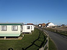
Some points of interest include a sand and shingle beach, Martello tower 55, two caravan sites and a The Star Inn public house. To the north is protected marshland known as Pevensey Levels, and the abandoned medieval village of Northeye.
Shipwreck edit
In 2005 divers trying to free a lobster pot discovered a large anchor and cannons offshore. This was at first thought to be the remains of the English warship HMS Resolution, which sunk there in 1703.[4] However, ongoing research suggests the wreck might be that of the Dutch warship Wapen van Utrecht, sunk during the Battle of Beachy Head in 1690.[5]
References edit
- ^ "Normans' Bay, Rother". GetOutside. Ordnance Survey. Retrieved 18 October 2022.
- ^ "Sussex Online Parish Clerks (OPC) home page". www.sussex-opc.org. Retrieved 9 November 2022.
- ^ "The Story of Bexhill Street Names". bexhill-osm.org.uk. Retrieved 9 November 2022.
- ^ The Resolution Project
- ^ "Normans Bay Wreck".
50°49′33″N 0°23′34″E / 50.8257°N 0.3929°E