


Summary
North Wollongong is a coastal suburb of the City of Wollongong, New South Wales, Australia. It is immediately to the north of the Wollongong city centre. Although North Wollongong is an official suburb with precise boundaries, the term North Wollongong may refer to northern areas of Wollongong which are not part of the suburb.
| North Wollongong Wollongong, New South Wales | |||||||||||||||
|---|---|---|---|---|---|---|---|---|---|---|---|---|---|---|---|
 | |||||||||||||||
 North Wollongong | |||||||||||||||
| Coordinates | 34°25′S 150°53′E / 34.417°S 150.883°E | ||||||||||||||
| Population | 2,608 (2016 census)[1] | ||||||||||||||
| Postcode(s) | 2500 | ||||||||||||||
| Elevation | 7 m (23 ft) | ||||||||||||||
| Location |
| ||||||||||||||
| LGA(s) | City of Wollongong | ||||||||||||||
| State electorate(s) | Wollongong, Keira | ||||||||||||||
| Federal division(s) | Cunningham | ||||||||||||||
| |||||||||||||||
Geography edit
The suburb has a beach, North Wollongong Beach, or simply North Beach, with adjacent cafes and restaurants as well as the Novotel Northbeach Hotel.[2]
Most of North Wollongong is commercial or residential with many of Wollongong's highrises situated there. The main commerce is along a strip on the Princes Highway near North Wollongong Station and the overpass as well as another strip on the north (western) side of the overpass including food stores. North Wollongong is the terminal of Mount Ousley Road, the main route to Sydney.[3]
History edit
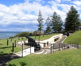
In 1893 Smiths Hill Fort was built to fend off possible Russian attack; two of the three original cannons remain.
The suburb achieved tourist popularity in the 1920s, and many Norfolk Island Pines planted during that era still remain. A Bather's Pavilion was opened in 1936.[2]
Amenities edit
North Beach is a popular surfing and swimming destination with a year-round surf patrol.[4] The North Wollongong beachfront is also the beginning of the Heartcare Foundation section of the Wollongong to Thirroul Bike Track which runs adjacent to the coast to Thirroul to the north. West of North Beach is a small strip of park along the cliff that runs between Cliff Road and the bike track; this is the location of Smiths Hill Fort.
North Wollongong has a beachside recreation ground, Stuart Park, which also houses the headquarters of Skydive the Beach. North of the park is Puckeys Estate Reserve.[3]
Heritage listings edit
North Wollongong has a number of heritage-listed sites, including:
- Cliff Road: North Beach Precinct[5]
References edit
- ^ Australian Bureau of Statistics (27 June 2017). "North Wollongong (State Suburb)". 2016 Census QuickStats. Retrieved 15 July 2017.
- ^ a b "North Wollongong". Wollongong City Libraries. December 2012. Retrieved 13 March 2014.
- ^ a b "Wollongong & Surrounds". Visit NSW. Retrieved 18 May 2013.
- ^ "Beaches and Pools". Wollongong City Council. January 2014. Retrieved 13 March 2014.
- ^ "North Beach Precinct". New South Wales State Heritage Register. Department of Planning & Environment. H01737. Retrieved 18 May 2018.
 Text is licensed by State of New South Wales (Department of Planning and Environment) under CC-BY 4.0 licence.