


Summary
Norwood is a suburb of Adelaide, about 4 km (2.5 mi) east of the Adelaide city centre. The suburb is in the City of Norwood Payneham & St Peters, whose predecessor was the oldest South Australian local government municipality.
| Norwood Adelaide, South Australia | |||||||||||||||
|---|---|---|---|---|---|---|---|---|---|---|---|---|---|---|---|
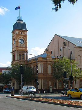 The Norwood Town Hall on The Parade | |||||||||||||||
| Population | 6,354 (SAL 2021)[1] | ||||||||||||||
| Established | 1847 | ||||||||||||||
| Postcode(s) | 5067 | ||||||||||||||
| Location | 4 km (2 mi) from Adelaide | ||||||||||||||
| LGA(s) | City of Norwood Payneham & St Peters | ||||||||||||||
| State electorate(s) | Dunstan | ||||||||||||||
| Federal division(s) | Sturt | ||||||||||||||
| |||||||||||||||
The Parade runs east to west through the centre of the suburb. Two roads run parallel to this, also along the whole length of the suburb: Beulah Road to the north, and William Street to the south.
History edit

Before British colonisation of South Australia and subsequent European settlement, Norwood was inhabited by one of the groups who later collectively became known as the Kaurna peoples.[2][3]
Early settler Edward Stephens, who arrived in the colony in 1839, wrote: "Norwood and Kent Town were unknown then. The site of the present Norwood was then a magnificent gum forest, with an undergrowth of kangaroo grass, too high in places for a man to see over; in fact persons lost their way in going from Adelaide to Kensington in those days, through attempting a short or near cut across the country".[4]
Norwood is named after Norwood, then a village south of London. The new village east of Adelaide was first laid out in 1847.[5] The former City of Kensington and Norwood was the first outside of the City of Adelaide to receive the right to set up their own municipal corporation. The charter of the town was given on 7 July 1853 by the Governor, Sir Henry Young.[6]
Trams edit
The first permanent street-based public transport service in Adelaide was provided in Norwood and Kensington, and these suburbs were also the first to be served by electric trams. The Adelaide and Suburban Tramway Company, the first horse-drawn tram company, started laying tracks from the City of Adelaide to Norwood and Kensington in 1877, with the first trams running in June 1878. The Adelaide and Suburban Tramway Company was acquired by the Municipal Tramways Trust, and the Kensington line converted to an electric tramway in 1909. The interim Kensington terminus was at The Parade/Gurrs Road intersection, before being extended, as part of the network of Adelaide trams, to serve the recently created reserve up The Parade at Kensington Gardens.[7]
Until 1952, the service was linked in with the other eastern suburbs tramlines and terminated in the city, but in that year it was "through routed" with trams running to Henley Beach. The tramway closed in February 1957.[7]
Jubilee Cycling Arena edit
In February 1951 the Jubilee Cycling Arena, aka Norwood Velodrome, opened on Osmond Terrace. It was a steeply banked concrete velodrome, with six laps to the mile, designed by Eddie Smith. During the summer, there were races held every Friday night. It became a popular spot for keen cyclists,[8] and was also used as a venue for square dancing in the 1950s.[9]
In 1965 over A$11,000 was raised by cyclists of the Norwood Cycling Club to re-concrete the track.[10]
In 1970, residents organised protests and a green ban in order to stop the destruction of the Norwood Velodrome for high-rise apartments.[11] However, Norwood Council sold the velodrome and surrounding land to real estate developers in 1981.[10][12]
Geography and landmarks edit
The suburb consists of four segments, being divided into north and south by the major thoroughfare of The Parade and east and west by Osmond Terrace. It is bounded on the south by Kensington Road on the north by Magill Road, on the east by Portrush Road and on the west by Fullarton Road. It is a leafy suburb, with streets lined with plane trees.
First Creek and Second Creek once flowed through the suburb, but First Creek is only visible between Edward Street and Birrell Street,[13] and both creeks are mostly underground in concrete tunnels.[4]
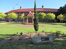
Osmond Terrace is a street with a wide grass, median strip featuring a prominent war memorial commemorating ANZAC soldiers who fought in the first and second World Wars, created by architect H.F.R. Culley.[14][15] The median strip also features sculptures from local artists,[16] and rose gardens. There is a sculpture of the first Italian to arrive in the new colony of South Australia in 1839, Antonio Giannoni (1814–1883), who worked as a cab driver in Norwood, and whose son, Peter Gannoni, became mayor in 1920.[17][18] The memorial bust, created by Wandrina Douglas-Boers,[16] was unveiled in November 1993.[19]
One of the most visible landmarks in Norwood is the Clayton Wesley Uniting Church, at the eastern end of The Parade, on the north-east corner of Portrush Road. Actually located in Beulah Park, the church and spire that are visible along the road from Norwood was built in 1883, although an earlier building (still behind the present church) was built in 1856.[20] The Norwood Town Hall is on the north-western corner of The Parade and George Street.
Demography edit
| Year | Pop. | ±% |
|---|---|---|
| 2001 | 5,358 | — |
| 2006 | 5,704 | +6.5% |
| 2011 | 5,802 | +1.7% |
| 2016 | 5,953 | +2.6% |
| 2021 | 6,354 | +6.7% |
Norwood attracted many European migrants post-World War II, in particular Italians.[21] In the 2016 Australian census, 4.1% of the population spoke Italian at home, with Greek coming a close second at 3%.[22] By the 2016 Australian census, the top language other than English spoken at home was Mandarin Chinese, at 3.6%, while 3.2% of the population spoke Italian and 2.8% Greek.[23]
In 2016, there were 5,953 people living in the suburb, with a median income of A$1,485 per week. The top ancestries in 2016 were English, at 26.3% and Australian, at 17%. Only 64.4% were born in Australia, while 43.2% had both parents born in Australia.[23]
Sport edit
Norwood Oval edit
Norwood Oval, as of 2021[update] known as the Coopers Stadium, on The Parade, is home to the Norwood Redlegs, a South Australian National Football League (Australian Rules Football) team It also hosts some AFL Women's (national league) matches, including the Adelaide Crows. It is the former home of Adelaide Bite, an Australian Baseball League team .[24]
Norwood Cycling Club edit
The Norwood Cycling Club (NCC) is the largest cycling club in South Australia, with 380 members as of 2021[update],[12] and its 1883 foundation date makes it the oldest such club in the southern hemisphere. It was founded as the Norwood Cycle and Motor Club,[25] and its official opening was at Kensington Oval, a bit further up The Parade in the suburb of Kensington, on 4 February 1884. Sir Edwin Smith was a foundation member and patron of the club, which became incorporated in 1918, after it had bought land and built clubrooms at Port Noarlunga. After the Jubilee Cycling Arena was built in Norwood in 1951, the club's members used to race there, and in 1965 the club raised money to concrete the track. Its clubrooms opened in George Street in 1975.[10][12]
Former members of the club include many champions, including Jack Bobridge, Luke Roberts, Tim Roe, Alexis Rhodes, Tiffany Cromwell, Patrick Jonker, Michael Turtur, David Solari (son of Nino Solari[26]), Wayne McCarney, Charlie Walsh and Jay Sweet.[25]
Each year the club promotes four major cycling events:[10]
- the Noarlunga Road race (since 1919);
- the Burra 2-day Classic;
- the Tour of the Riverland (established 1975); and
- the AlphutteClassic Handicap.
NCC is affiliated with Cycling SA, which is in turn affiliated with the national parent body of the state bodies, Cycling Australia.[12]
Attractions edit
Norwood is known for its many restaurants[27][28] and shops selling fashion and goods of all kinds.[29][30] It also plays host to a variety of events and festivals throughout the year.[31]
Odeon Theatre edit

The Odeon Theatre is on the corner of The Parade and Queen Street. Originally the Star Theatre,[32] it was designed as a picture theatre by Sydney architects Kaberry and Chard[33] (who also designed the Thebarton Theatre,[34] the Athenium Theatre in Junee, New South Wales,[35] and many other cinemas across Australia[34]) in association with local supervising architect Chris A. Smith. It was officially opened by Norwood mayor William Essery (Snr) on Wednesday 16 May 1923,[33][36] with its entrance on The Parade. The operator was D. Clifford Theatres (formerly Star Theatres) by 1946. Later it was taken over by Greater Union Cinemas and renamed the Odeon Theatre (also known as Odeon Norwood). It closed as a cinema, reopening in 1986 as a live theatre specialising in children's productions. The entrance was moved around the corner onto Queen Street, and the original foyer converted into restaurant,[32] as of 2024[update] St Louis dessert bar.[37]
As of February 2024[update], the Odeon is home to Australian Dance Theatre, which offers dance classes to adults. The venue is hired out for various performing arts events,[38] such as the Adelaide Festival,[39] Adelaide Fringe[40] and State Theatre Company of South Australia performances.[41]
Notable buildings edit
- Norwood Town Hall was heritage-listed on the SA Heritage Register in November 1985.[42]
- Norwood Library is located on 110 The Parade, near the corner of Osmond Terrace, in the old Kensington and Norwood Institute building,[43] which was heritage-listed in 1981 on the South Australian Heritage Register.[44] The institute, designed by government architect W. H. Abbott free of charge, and built in 1876, was one of many mechanics' institutes in Australia established during the 19th century. It was largely funded by its founding president, Sir Edwin Smith. In 1882 its collection, available for loan by subscriptions paid by members, was enhanced by books acquired from the Magill Institute after its demise. In 1883 extensions were added to the building, including a hall and reading room, and in 1895 it also had a musical program. In 1914 the library held 13,744 volumes, and 190 periodicals and newspapers, and an art school was opened in the building. In the 1950s the Institute supported the free lending of books, but fell into debt to the council. In 1977 the City of Kensington and Norwood acquired the building, and carried out renovations, retaining the library. In 1986 the institute was dissolved, setting up a Friends of the Library group as the building becoming the responsibility of the council. The building was refurbished in period style and became Norwood Library.[43]
- The former Norwood Baptist Church, on the south-eastern corner of Church Avenue and The Parade (no. 134), designed by architect James Cumming, built in 1869[45] by Charles Farr and opened in January 1870,[46] was heritage-listed on the SA Heritage Register in 1982.[47] Its classical style was particularly influenced by the Metropolitan Tabernacle in Newington Butts in London, where influential Baptist preacher Charles Spurgeon used to preach. The building contains one of the most significant church organs in South Australia, installed in 1882. Its use as a church ceased and for some time it housed the Mary Martin Bookshop,[45] but that closed in the 2010s and has since been used as a restaurant.
Churches edit

Saint Ignatius Church is a Catholic parish church, built after land at the north-eastern corner of William and Queen Streets was purchased by the Society of Jesus (more commonly referred to as Jesuits) in 1869 and the church built in Italianate style and opened in August 1870.[48]
Saint Bartholomew's on Beulah Road in Norwood, also known as St Bart's Norwood, is "an Anglican church in the evangelical tradition that participates as a member of the Anglican Communion".[49] It was for some years part of the Grace Anglican Network (created by St Bart's in 2016[50]) with St Matthew's Church, Marryatville,[51] but as of February 2022[update] is again independent.[52]
The Unitarian Meeting House at 99 Osmond Terrace is an independent, self-governed church "affiliated with the worldwide Unitarian and Unitarian-Universalist free church movements".[53]
Schools edit
- Norwood Primary School, Osmond Terrace,[54] which was designed and built by the same architect and builder as the Norwood Baptist Church, architect James Cumming and builder Charles Farr, as Norwood Public School in 1871.[55]
- Saint Ignatius' College, junior campus
- The upper primary campus of St Joseph's Memorial School, catering for children, William Street, caters for Year 2 to Year 6 (junior primary, preschool to Year 1, is in Bridge Street, Kensington).[56]
Transport edit
Several Adelaide Metro bus routes serve the suburb. These are the main routes running through or adjacent to Norwood as of 2020[update]:[57]
- H30, H33: Magill Road
- H20, H21, H22, H23, H24, N22: The Parade
- 140, 141,142: Kensington Road
- 300: Suburban Connector (Portrush Road)
In addition to these, there are a number of school services running during term-time, and special services to Adelaide Oval for big events.[57]
Notable residents edit
- Reginald Blundell, politician[58]
- C.J. Dennis, writer[59]
- Bill Denny, politician[59]
- Don Dunstan, former Premier of South Australia[60]
- Antonio Giannoni, first Italian settler in South Australia[19]
- May Gibbs, writer[59]
- Max Harris, poet[59]
- Lionel Hill, politician[59]
- Mary MacKillop, Australia's first beatified saint[59]
- Mary Martin, bookseller[59]
- Sir Edwin Thomas Smith[59]
- Catherine Helen Spence, women's rights campaigner[61]
- Alexander Tolmer, former police officer and police commissioner[citation needed]
- Stanley Price Weir, public servant and Australian Army officer[59]
See also edit
- Electoral district of Norwood
- List of Adelaide suburbs
- Norwood Swimming Pool (in neighbouring Kensington)
- Woodroofe, a soft drink company
References edit
- ^ Australian Bureau of Statistics (28 June 2022). "Norwood (SA) (suburb and locality)". Australian Census 2021 QuickStats. Retrieved 28 June 2022.
- ^ Lockwood, Christine (2017). "4. Early encounters on the Adelaide Plains and Encounter Bay". In Brock, Peggy; Gara, Tom (eds.). Colonialism and its Aftermath: A history of Aboriginal South Australia. Wakefield Press. pp. 65–81. ISBN 9781743054994.
- ^ Horton, David R. (1996). "Map of Indigenous Australia". AIATSIS. Retrieved 16 August 2021.
- ^ a b Stephens, Edward. "Second Creek at Norwood". SA Memory. Extracted from Stephens, Edward. The aborigines of Australia: being personal recollections of those tribes which once inhabited the Adelaide Plains of South Australia, in the Proceedings of the Royal Society of New South Wales, V.XXIII, 1889. State Library of South Australia. Retrieved 16 August 2021.
- ^ "The History of Kensington & Norwood". Archived from the original on 20 July 2008.
- ^ "History of the Norwood Electorate". Steven Marshall. 10 April 2013. Archived from the original on 10 April 2013.
- ^ a b "The Eastern Lines". Tramway Museum, St Kilda. 17 March 1956. Retrieved 20 September 2020.
- ^ "Cycling". Victor Harbor Times. Vol. 44, no. 2170. South Australia. 26 November 1954. p. 4. Retrieved 20 September 2020 – via National Library of Australia.
- ^ "The Odd spot". The News (Adelaide). Vol. 60, no. 9, 266. South Australia. 22 April 1953. p. 3. Retrieved 20 September 2020 – via National Library of Australia.
- ^ a b c d "Club History - Norwood Cycling Club". Norwood Cycling Club. 10 March 2014. Archived from the original on 12 August 2020. Retrieved 15 August 2021.
- ^ Burgmann, Verity and Meredith (1998). Green Bans, Red Union: Environmental Activism and the New South Wales Builders Labourers' Federation. p. 52.
- ^ a b c d "Club History". Norwood Cycling Club. Retrieved 15 August 2021.
- ^ "Norwood · South Australia 5067, Australia". Norwood · South Australia 5067, Australia. Retrieved 16 August 2021.
- ^ "Norwood War Memorial, Norwood, South Australia, Australia". Virtual War Memorial. Retrieved 15 August 2021.
- ^ "Norwood War Memorial". Monument Australia. 2 June 1923. Retrieved 15 August 2021.
- ^ a b "Public Art Map". City of Norwood Payneham & St Peters. Retrieved 15 August 2021.
- ^ O' Connor, Desmond (15 August 2014). "Italians". SA History Hub. History Trust of South Australia. Retrieved 15 August 2021.
This is a revised version of an entry first published in The Wakefield companion to South Australian history, edited by Wilfrid Prest, Kerrie Round and Carol Fort (Adelaide: Wakefield Press, 2001). Revised by the author and edited lightly.
- ^ "Kensington and Norwood". South Australian Register. Vol. LVIII, no. 14, 676. South Australia. 25 November 1893. p. 7. Retrieved 15 August 2021 – via National Library of Australia.
- ^ a b "Antonio Giannoni". Monument Australia. Retrieved 15 August 2021.
- ^ "History". Clayton Wesley Uniting Church. Retrieved 16 August 2021.
- ^ Burnley, I. H. (1975). "Immigrant Absorption in the Australian City, 1947-1971". The International Migration Review. 9 (3). Center for Migration Studies of New York, Inc., Wiley: 331. doi:10.2307/3002248. ISSN 0197-9183. JSTOR 3002248. Retrieved 15 August 2021.
- ^ Australian Bureau of Statistics (25 October 2007). "Norwood (State Suburb)". 2006 Census QuickStats. Retrieved 4 September 2015.
- ^ a b Australian Bureau of Statistics (27 June 2017). "Norwood (State Suburb)". 2016 Census QuickStats. Retrieved 8 August 2019.
- ^ "Norwood Oval (Coopers Stadium)". Austadiums. 26 August 2005. Retrieved 15 August 2021.
- ^ a b "AdelaideAZ". AdelaideAZ. Retrieved 15 August 2021.
- ^ Migliaccio, Val (20 June 2018). "Tributes flow for cycling legend Solari". The Advertiser. Adelaide. Retrieved 15 August 2021.
- ^ "Restaurants & Cafes". The Parade. Retrieved 15 August 2021.
- ^ "Norwood Restaurants - Adelaide". WeekendNotes (in Afrikaans). Retrieved 15 August 2021.
- ^ "Shop". The Parade. Retrieved 15 August 2021.
- ^ "Norwood". South Australia. South Australian Tourism Commission. 21 January 2021. Retrieved 15 August 2021.
- ^ "Culture & Lifestyle". City of Norwood Payneham & St Peters. Retrieved 15 August 2021.
- ^ a b "Odeon Norwood in Adelaide, AU". Cinema Treasures. 17 February 2018. Retrieved 29 July 2020.
- ^ a b "Norwood Star Theatre". The Register (Adelaide). Vol. LXXXVIII, no. 25, 705. South Australia. 17 May 1923. p. 10. Retrieved 15 February 2024 – via National Library of Australia.
- ^ a b "Thebarton Theatre: History". Thebarton Theatre. Retrieved 19 December 2022.
- ^ "Athenium Theatre". New South Wales State Heritage Register. Department of Planning & Environment. H01687. Retrieved 15 February 2024.
 Text is licensed by State of New South Wales (Department of Planning and Environment) under CC-BY 4.0 licence.
- ^ Hennessy, Antoinette (2016). Entertaining the Classes: An archaeological investigation of historic cinemas in Metropolitan Adelaide, South Australia, and their development in relation to social class, 1896-1949 (MA). Flinders University. p. 97. Retrieved 18 December 2022.PDF
- ^ "Locations - Crafted European Desserts". St. Louis. 28 November 2021. Retrieved 15 February 2024.
- ^ "The Odeon Theatre - Australian Dance Theatre". The Parade. Retrieved 15 February 2024.
- ^ "Odeon Theatre". Adelaide Festival. Retrieved 29 July 2020.
- ^ "Events located at The Odeon Theatre". FringeVault. Retrieved 29 July 2020.
- ^ Cornelius, Patricia (11 December 2018). "In the club". State Theatre Company. Retrieved 29 July 2020.
- ^ "175 The Parade Norwood". The South Australia Heritage Places database. Retrieved 16 August 2021.
- ^ a b "Kensington and Norwood". Institutes of South Australia. 2021. Retrieved 4 January 2022.
- ^ "110 The Parade Norwood". The South Australia Heritage Places database. Retrieved 4 January 2022.
- ^ a b Maidment, John (10 August 2011). "Former Baptist Church The Parade, Norwood, South Australia". Organ Historical Trust of Australia. Retrieved 16 August 2021.
- ^ "Baptist Church, Norwood" (Photo + text). State Library of South Australia. Retrieved 16 August 2021.
- ^ "134 The Parade Norwood". The South Australia Heritage Places database. Retrieved 16 August 2021.
- ^ "About Us". Saint Ignatius Catholic Parish – Norwood South Australia. Retrieved 15 August 2021.
- ^ "Classes". St Bart's Norwood. 14 January 2022. Archived from the original on 17 February 2022. Retrieved 17 February 2022.
- ^ "Grace Brings Change to Adelaide". The Living Church. 10 June 2016. Archived from the original on 17 February 2022. Retrieved 17 February 2022.
- ^ "Make Jesus Known - Grace Anglican Network". Grace Anglican Network. 2 May 2020. Archived from the original on 3 March 2021. Retrieved 17 February 2022.
- ^ "St Bart's Norwood". St Bart's Norwood. 14 January 2022. Retrieved 17 February 2022.
- ^ "Home page". SA Unitarians. Retrieved 16 August 2021.
- ^ "Home". Norwood Primary School. Retrieved 15 August 2021.
- ^ "Building Improvements for 1871". South Australian Register. Vol. XXXVII, no. 7842. South Australia. 4 January 1872. p. 7. Retrieved 15 August 2021 – via National Library of Australia.
- ^ "Our History". St Joseph's Memorial School. Retrieved 20 December 2023.
- ^ a b "Search Results [Norwood]". Adelaide Metro. 12 February 2020. Retrieved 20 September 2020.
- ^ Jaensch, Dean (1979). "Blundell, Reginald Pole (1871 - 1945)". Australian Dictionary of Biography. National Centre of Biography, Australian National University. ISSN 1833-7538. Retrieved 15 August 2021.
- ^ a b c d e f g h i "Signs, Walks & Trails". City of Norwood Payneham & St Peters. Retrieved 15 August 2021.
- ^ "Dunstan Biography". Flinders University. 22 January 2010. Archived from the original on 22 January 2010.
- ^ "Death of Miss Spence". The Evening Journal (Adelaide). South Australia. 4 April 1910. p. 2. Retrieved 15 August 2021 – via Trove.
External links edit
- Norwood Payneham & St Peters Council
34°55′23″S 138°37′59″E / 34.923°S 138.633°E