


Summary
Numinbah Valley is a rural locality in the City of Gold Coast, Queensland, Australia.[2] In the 2016 census, Numinbah Valley had a population of 218 people.[1]
| Numinbah Valley Gold Coast, Queensland | |||||||||||||||
|---|---|---|---|---|---|---|---|---|---|---|---|---|---|---|---|
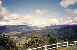 Numinbah Valley from Rosin's Lookout | |||||||||||||||
 Numinbah Valley | |||||||||||||||
 | |||||||||||||||
| Coordinates | 28°08′50″S 153°13′49″E / 28.1472°S 153.2302°E | ||||||||||||||
| Population | 218 (2016 census)[1] | ||||||||||||||
| • Density | 3.739/km2 (9.685/sq mi) | ||||||||||||||
| Established | 1880 | ||||||||||||||
| Postcode(s) | 4211 | ||||||||||||||
| Area | 58.3 km2 (22.5 sq mi) | ||||||||||||||
| Time zone | AEST (UTC+10:00) | ||||||||||||||
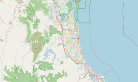
| Location |
| ||||||||||||||
| LGA(s) | City of Gold Coast | ||||||||||||||
| State electorate(s) | Mudgeeraba | ||||||||||||||
| Federal division(s) | McPherson | ||||||||||||||
| |||||||||||||||
Geography edit

The Numinbah Valley is a valley and locality in the Gold Coast hinterland in South East Queensland. This Scenic Rim valley covers 116 km2[3] and contains cleared grazing land, rocky outcrops, waterfalls, rainforest walks and good hinterland scenery. Lonely Planet has described the valley as the most beautiful in South East Queensland.[4]
Compared to other areas of the Gold Coast the Numinbah Valley has remained largely undeveloped in recent decades. To the east is the Springbrook plateau. On the eastern side of the valley is the Natural Bridge in Springbrook National Park and to the west lies the Lamington Plateau and the Lamington National Park. To the south is the Tweed Valley in northern New South Wales.
Vegetation in the valley includes dry and wet sclerophyll forest. The valley is part of the upper catchment area for the Nerang River which flows into the Hinze Dam in the lowest elevated and most northern part of the valley. The communities of Advancetown and the small township of Numinbah are located in Numinbah Valley.
The river which lies in the Numinbah valley region is home to the duck billed platypus. The platypus is regularly seen in Bonchow park and Forest park in Numinbah valley. recent studies show that most of the platypus population on the Gold Coast lies in Numinbah valley and Canungra fresh water streams including Scenic Rim suburbs such as Palen Creek, Rathdowney, Mount Barney and surrounding suburbs.
Road infrastructure edit
The Nerang–Murwillumbah Road runs through from north to south. [5]
History edit
The valley was first explored by timber cutters seeking cedar in 1845.[6] Bullocks hauled the felled timber to Nerang. Later in the 1860s, when a route to the Tweed Valley was discovered as surveyors mapped the Queensland/New South Wales border, settlers moved into the area.[6]
A township developed in the 1880s.[6]
A sawmill operated from 1909 until 1944 when agriculture and dairying became the primary industries.[6]
Numinbah Provisional School opened on 7 February 1927. In 1938 it became Numinbah Valley State School.[7]
In the 2016 census, Numinbah Valley had a population of 218 people.[1]
Industry edit
At one of three places in Queensland perlite is extracted from a deposit in the valley and trucked to Sydney.[8]
Facilities edit

The Numinbah Correctional Centre is located within the locality.
Community groups edit
A Numinbah Valley Landcare group operates in the valley.
Education edit

Numinbah Valley State School is a government primary (Prep-6) school for boys and girls at 2270 Nerang-Murwillumbah Road (28°08′55″S 153°13′38″E / 28.1486°S 153.2272°E).[9][10] In 2017, the school had an enrolment of 14 students with 7 teachers (2 full-time equivalent) and 4 non-teaching staff (2 full-time equivalent).[11]
Numinbah Valley Environmental Education Centre is an Outdoor and Environmental Education Centre at 1721 Nerang-Murwillumbah Road (28°06′35″S 153°14′37″E / 28.1096°S 153.2437°E).[9][12]
There is no secondary school in Numinbah Valley. The nearest secondary school is Nerang State High School in Nerang to the north-east.[13]
Attractions edit
The Gold Coast Hinterland Great Walk traverses the valley from O'Reilly's Guesthouse in the west to Springbrook National Park to the east.
Bornhoffen PCYC or the Numinbah Valley Environmental Education Centre caters for large groups of students. These large recreational facilities are situated in the southern and highest part where the headwaters of the Nerang River coalesce.
Heritage listings edit
Numinbah Valley has a number of heritage-listed sites, including:
- 365 Chesters Road: Banana Packing Shed [14]
- 2136 Nerang Murwillumbah Road: Numinbah Valley School of Arts [15] [16]
See also edit
References edit
- ^ a b c Australian Bureau of Statistics (27 June 2017). "Numinbah Valley (SSC)". 2016 Census QuickStats. Retrieved 20 October 2018.
- ^ "Numinbah Valley – locality in City of Gold Coast (entry 47851)". Queensland Place Names. Queensland Government. Retrieved 18 September 2020.
- ^ "Numinbah History". Gold Coast City Council. Archived from the original on 5 April 2013. Retrieved 27 June 2013.
- ^ Bain, Andrew; Ethan Gelber (2009). Cycling Australia. Lonely Planet. p. 291. ISBN 174104040X. Retrieved 27 June 2013.
- ^ Numinbah Valley, Queensland (Map). OpenStreetMap. Retrieved 25 February 2022.
- ^ a b c d Environmental Protection Agency (Queensland) (2000). Heritage Trails of the Great South East. State of Queensland. p. 20. ISBN 0-7345-1008-X.
- ^ Queensland Family History Society (2010), Queensland schools past and present (Version 1.01 ed.), Queensland Family History Society, ISBN 978-1-921171-26-0
- ^ Kogel, Jessica Elzea; Nikhil C. Trivedi; James M. Barker (2006). Industrial Minerals and Rocks: Commodities, Markets, and Users. SME. p. 687. ISBN 0873352335. Retrieved 27 June 2013.
- ^ a b "State and non-state school details". Queensland Government. 9 July 2018. Archived from the original on 21 November 2018. Retrieved 21 November 2018.
- ^ "Numinbah Valley State School". Archived from the original on 8 October 2020. Retrieved 21 November 2018.
- ^ "ACARA School Profile 2017". Archived from the original on 22 November 2018. Retrieved 22 November 2018.
- ^ "Numinbah Valley Environmental Education Centre". Archived from the original on 31 October 2018. Retrieved 21 November 2018.
- ^ "Queensland Globe". State of Queensland. Retrieved 8 October 2020.
- ^ Gold Coast Local Heritage Register - A to M, pp. 5-7
- ^ "Numinbah Valley School of Arts (entry 602419)". Queensland Heritage Register. Queensland Heritage Council. Retrieved 19 June 2013.
- ^ Gold Coast Local Heritage Register - N to Z, pp. 89-90
Sources edit
- "Gold Coast Local Heritage Register - A to M" (PDF). Gold Coast City Council. Retrieved 26 August 2020.
Further reading edit
- Holt, R. W. (1978), A history of the Congregational, Methodist, and Presbyterian Churches in Southport and environs, leading up to the inauguration of the Southport Uniting Parish, Southport Uniting Parish
External links edit
- "Gold Coast Inner Hinterland". Queensland Places. Centre for the Government of Queensland, University of Queensland. — includes Numinbah Valley