


Summary
Nunavut (/ˈnʊnəvʊt/, /ˈnuːnəvuːt/; French: [nunavut], [nunavʊt], [nynavʏt]; Inuktitut: ᓄᓇᕗᑦ, [nunaˈvut], lit. 'our land'[11]) is the largest and northernmost territory of Canada. It was separated officially from the Northwest Territories on April 1, 1999, via the Nunavut Act[12] and the Nunavut Land Claims Agreement Act,[13] which provided this territory to the Inuit for independent government. The boundaries had been drawn in 1993. The creation of Nunavut resulted in the first major change to Canada's political map in half a century since the province of Newfoundland (now Newfoundland and Labrador) was admitted in 1949.
Nunavut | |
|---|---|
| Motto(s): ᓄᓇᕗᑦ ᓴᙱᓂᕗᑦ (Nunavut Sannginivut) "Our land, our strength" "Notre terre, notre force" | |
| Coordinates: 70°10′N 90°44′W / 70.167°N 90.733°W[1] | |
| Country | Canada |
| Before confederation | District of Franklin, District of Keewatin |
| Confederation | April 1, 1999 (13th) |
| Capital (and largest city) | Iqaluit |
| Government | |
| • Type | Parliamentary system, with consensus government |
| • Commissioner | Eva Aariak |
| • Premier | P.J. Akeeagok |
| Legislature | Legislative Assembly of Nunavut |
| Federal representation | Parliament of Canada |
| House seats | 1 of 338 (0.3%) |
| Senate seats | 1 of 105 (1%) |
| Area | |
| • Total | 1,997,923.78 km2 (771,402.68 sq mi) |
| • Land | 1,836,993.78 km2 (709,267.26 sq mi) |
| • Water | 160,930 km2 (62,140 sq mi) 8.1% |
| • Rank | 1st |
| 20% of Canada | |
| Population (2021) | |
| • Total | 36,858[2] |
| • Estimate (Q1 2024) | 40,721[4] |
| • Rank | 13th |
| • Density | 0.02/km2 (0.05/sq mi) |
| Demonym(s) | Nunavummiut Nunavummiuq (sing.)[5] |
| Official languages | Inuit (Inuktitut and Inuinnaqtun)[6] English French |
| GDP | |
| • Rank | 12th |
| • Total (2017) | C$2.846 billion[7] |
| • Per capita | C$58,452 (6th) |
| HDI | |
| • HDI (2021) | 0.930[8] – Very high (4th) |
| Time zones | UTC-07:00 (Mountain Time) |
| • Summer (DST) | UTC-06:00 |
| UTC-06:00 (Central Time) | |
| • Summer (DST) | UTC-05:00 |
| Southampton Island (Coral Harbour) | UTC-05:00 (Eastern Time) |
| UTC-05:00 (Eastern Time) | |
| • Summer (DST) | UTC-04:00 |
| Canadian postal abbr. | NU |
| Postal code prefix | |
| ISO 3166 code | CA-NU |
| Flower | Purple saxifrage[9] |
| Tree | n/a |
| Bird | Rock ptarmigan[10] |
| Rankings include all provinces and territories | |


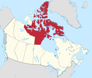
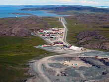
Nunavut comprises a major portion of Northern Canada and most of the Arctic Archipelago. Its vast territory makes it the fifth-largest country subdivision in the world, as well as North America's second-largest (after Greenland). The capital Iqaluit (formerly Frobisher Bay), on Baffin Island in the east, was chosen by a capital plebiscite in 1995. Other major communities include the regional centres of Rankin Inlet and Cambridge Bay.
Nunavut also includes Ellesmere Island to the far north, as well as the eastern and southern portions of Victoria Island in the west, and all islands in Hudson, James and Ungava bays, including Akimiski Island far to the southeast of the rest of the territory. It is Canada's only geopolitical region that is not connected to the rest of North America via the Pan-American Highway.[14]
Nunavut is the least densely populated major country sub-division in the world (not considering Antarctica), being even less densely populated than Denmark's Greenland. With a population of 36,858 as of the 2021 Canadian census (up from 35,944 in 2016) consisting mostly of Inuit, and a land mass almost as large as Mexico, Nunavut's land area of 1,836,993.78 km2 (709,267.26 sq mi)[2] is occupied with a population density of 0.022/km2 (0.056/sq mi). Nunavut is also home to the world's northernmost continuously inhabited place, Alert.[15] Eureka, a weather station on Ellesmere Island, has the lowest average annual temperature of any Canadian weather station.[16]
History edit
Early history edit

The region which is now mainland Nunavut was first populated approximately 4,500 years ago by the Pre-Dorset, a diverse Paleo-Eskimo culture that migrated eastward from the Bering Strait region.[17]
The Pre-Dorset culture was succeeded by the Dorset culture about 2,800 years ago.[18] Anthropologists and historians believe that the Dorset culture developed from the Pre-Dorset somehow.[18]
Helluland, which Norse explorers described visiting in their Sagas of Icelanders, has been associated with Nunavut's Baffin Island. Claims of contact between the Dorset and Norse are controversial.[19][20]
The Thule people, ancestors of the modern Inuit, began migrating from Alaska in the 11th century into the Northwest Territories and Nunavut. By 1300, the geographic extent of Thule settlement included most of modern Nunavut.
The migration of the Thule people coincides with the decline of the Dorset, who died out between 800 and 1500.[21]
European exploration edit

The earliest written historical account of the area is dated to 1576, an account by English explorer Martin Frobisher. While leading an expedition to find the Northwest Passage, Frobisher thought he had discovered gold ore around the body of water now known as Frobisher Bay on the coast of Baffin Island.[22] The ore turned out to be worthless, but Frobisher made the first recorded European contact with the Inuit. Other explorers in search of the elusive Northwest Passage followed in the 17th century, including Henry Hudson, William Baffin and Robert Bylot.
20th and 21st centuries edit
Cornwallis and Ellesmere Islands featured in the history of the Cold War in the 1950s. Concerned about the area's strategic geopolitical position, the federal government, as part of the High Arctic relocation, relocated Inuit from Nunavik (northern Quebec) to Resolute and Grise Fiord. In the unfamiliar and hostile conditions, they faced starvation[23] but were forced to stay.[24]
Forty years later, the Royal Commission on Aboriginal Peoples issued a report titled The High Arctic Relocation: A Report on the 1953–55 Relocation.[25] The government paid compensation to those affected and their descendants. On August 18, 2010, in Inukjuak, the Honourable John Duncan, PC, MP, previous Minister of Indian Affairs and Northern Development and Federal Interlocutor for Métis and Non-Status Indians formally apologized on behalf of the Government of Canada for the relocation of Inuit to the High Arctic.[26][27]
Discussions on dividing the Northwest Territories along ethnic lines began in the 1950s, and legislation to achieve this was introduced in 1963. After its failure, a federal commission recommended against such a measure.[28]
During the 1970s, activism increased among the Inuit, First Nations, and Innu peoples for recognition of their forced assimilation. In 1976, as part of the land claims negotiations between the Inuit Tapiriit Kanatami (then called the "Inuit Tapirisat of Canada") and the federal government, the parties discussed division of the Northwest Territories to provide a separate territory for the Inuit. On April 14, 1982, a plebiscite on division was held throughout the Northwest Territories. A majority of the residents voted in favour and the federal government gave a conditional agreement seven months later.[29]

The land claims agreement was completed in September 1992 and ratified by nearly 85% of the voters in Nunavut in a referendum. On July 9, 1993, the Nunavut Land Claims Agreement Act[13] and the Nunavut Act[12] were passed by the Canadian Parliament. The transition to establish Nunavut Territory was completed on April 1, 1999.[30]
In 2020, Nunavut imposed strict travel regulations in order to prevent an outbreak of the COVID-19 pandemic. The government barred entry to almost all non-residents.[31] As of October 2020, it was the only place in North America to have had no cases of COVID-19.[32] On November 6, 2020, Nunavut confirmed its first case in Sanikiluaq.[33]
Geography edit

Nunavut covers 1,836,993.78 km2 (709,267.26 sq mi)[2] of land and 160,930 km2 (62,137 sq mi)[3] of water in Northern Canada. The territory includes part of the mainland, most of the Arctic Archipelago, and all of the islands in Hudson Bay, James Bay, and Ungava Bay, including the Belcher Islands, all of which were part of the Northwest Territories from which Nunavut was separated. This makes it the fifth-largest subnational entity (or administrative division) in the world. If Nunavut were a country, it would rank 15th in area.[34]
Nunavut has long land borders with the Northwest Territories on the mainland and a few Arctic islands, and with Manitoba to the south of the Nunavut mainland; it also meets Saskatchewan to the southwest at a quadripoint, and has a short land border with Newfoundland and Labrador on Killiniq Island. The boundary with the Northwest Territories roughly approximates the tree line in Canada.[35] Nunavut shares maritime borders with the provinces of Quebec, Ontario, Manitoba, and with constituent country Greenland, with which it also shares a land border on Hans Island.
Nunavut's highest point is Barbeau Peak (2,616 m or 8,583 ft) on Ellesmere Island. The population density is 0.019 persons/km2 (0.05 persons/sq mi), one of the lowest in the world. By comparison, Greenland has approximately the same area and nearly twice the population.[36]
Climate edit

Nunavut experiences a polar climate in most regions, owing to its high latitude and lower continental summertime influence than areas to the west. In more southerly continental areas, very cold subarctic climates can be found, due to July being slightly milder than the required 10 °C (50 °F).
| City | July (°C) | July (°F) | January (°C) | January (°F) | ||||
|---|---|---|---|---|---|---|---|---|
| High | Low | High | Low | High | Low | High | Low | |
| Alert[37] | 6 | 1 | 43 | 33 | −29 | −36 | −20 | −33 |
| Baker Lake[38] | 17 | 6 | 63 | 43 | −28 | −35 | −18 | −31 |
| Cambridge Bay[39] | 13 | 5 | 55 | 41 | −29 | −35 | −19 | −32 |
| Eureka[40] | 9 | 3 | 49 | 37 | −33 | −40 | −27 | −40 |
| Iqaluit[41] | 12 | 4 | 54 | 39 | −23 | −31 | −9 | −24 |
| Kugluktuk[42] | 16 | 6 | 60 | 43 | −23 | −31 | −10 | −25 |
| Rankin Inlet[43] | 15 | 6 | 59 | 43 | −27 | −34 | −17 | −30 |
| Climate data for Iqaluit (Iqaluit Airport) WMO ID: 71909; coordinates 63°45′N 68°33′W / 63.750°N 68.550°W; elevation: 33.5 m (110 ft); 1991–2020 normals, extremes 1946–present | |||||||||||||
|---|---|---|---|---|---|---|---|---|---|---|---|---|---|
| Month | Jan | Feb | Mar | Apr | May | Jun | Jul | Aug | Sep | Oct | Nov | Dec | Year |
| Record high humidex | 3.3 | 5.2 | 4.3 | 6.8 | 13.3 | 21.7 | 27.8 | 27.6 | 18.8 | 8.6 | 4.8 | 3.4 | 27.8 |
| Record high °C (°F) | 3.9 (39.0) |
5.7 (42.3) |
4.2 (39.6) |
7.2 (45.0) |
13.3 (55.9) |
22.7 (72.9) |
26.8 (80.2) |
25.5 (77.9) |
18.4 (65.1) |
9.1 (48.4) |
5.6 (42.1) |
3.8 (38.8) |
26.8 (80.2) |
| Mean daily maximum °C (°F) | −22.0 (−7.6) |
−22.9 (−9.2) |
−17.6 (0.3) |
−8.9 (16.0) |
−0.3 (31.5) |
7.0 (44.6) |
12.0 (53.6) |
11.1 (52.0) |
5.6 (42.1) |
−0.5 (31.1) |
−7.5 (18.5) |
−14.7 (5.5) |
−4.9 (23.2) |
| Daily mean °C (°F) | −26.0 (−14.8) |
−27.0 (−16.6) |
−22.4 (−8.3) |
−13.5 (7.7) |
−3.2 (26.2) |
3.9 (39.0) |
8.1 (46.6) |
7.5 (45.5) |
2.9 (37.2) |
−3.2 (26.2) |
−11.1 (12.0) |
−18.9 (−2.0) |
−8.6 (16.5) |
| Mean daily minimum °C (°F) | −29.9 (−21.8) |
−31.0 (−23.8) |
−27.2 (−17.0) |
−18.1 (−0.6) |
−6.1 (21.0) |
0.7 (33.3) |
4.2 (39.6) |
3.8 (38.8) |
0.2 (32.4) |
−5.8 (21.6) |
−14.7 (5.5) |
−23.0 (−9.4) |
−12.2 (10.0) |
| Record low °C (°F) | −45.0 (−49.0) |
−45.6 (−50.1) |
−44.7 (−48.5) |
−34.2 (−29.6) |
−26.1 (−15.0) |
−10.2 (13.6) |
−2.8 (27.0) |
−2.5 (27.5) |
−12.8 (9.0) |
−27.1 (−16.8) |
−36.2 (−33.2) |
−43.4 (−46.1) |
−45.6 (−50.1) |
| Record low wind chill | −65.4 | −65.6 | −62.1 | −53.1 | −36.0 | −18.8 | −7.2 | −8.6 | −18.6 | −42.9 | −56.8 | −60.1 | −65.6 |
| Average precipitation mm (inches) | 16.3 (0.64) |
14.0 (0.55) |
21.4 (0.84) |
22.7 (0.89) |
21.0 (0.83) |
48.7 (1.92) |
39.8 (1.57) |
61.7 (2.43) |
50.8 (2.00) |
30.2 (1.19) |
18.5 (0.73) |
16.2 (0.64) |
361.2 (14.22) |
| Average rainfall mm (inches) | 0.4 (0.02) |
0.1 (0.00) |
0.0 (0.0) |
0.0 (0.0) |
3.3 (0.13) |
46.1 (1.81) |
44.4 (1.75) |
65.5 (2.58) |
43.9 (1.73) |
12.3 (0.48) |
0.7 (0.03) |
0.0 (0.0) |
216.6 (8.53) |
| Average snowfall cm (inches) | 19.4 (7.6) |
15.1 (5.9) |
20.6 (8.1) |
23.8 (9.4) |
23.0 (9.1) |
3.8 (1.5) |
0.0 (0.0) |
0.1 (0.0) |
8.5 (3.3) |
21.1 (8.3) |
25.9 (10.2) |
28.8 (11.3) |
190.0 (74.8) |
| Average precipitation days (≥ 0.2 mm) | 12.1 | 10.7 | 12.4 | 12.8 | 10.6 | 12.3 | 12.4 | 14.3 | 15.7 | 13.2 | 12.5 | 12.8 | 151.5 |
| Average rainy days (≥ 0.2 mm) | 0.06 | 0.06 | 0.06 | 0.06 | 1.7 | 10.7 | 13.1 | 14.8 | 13.2 | 3.8 | 0.24 | 0.0 | 57.7 |
| Average snowy days (≥ 0.2 cm) | 10.1 | 8.8 | 8.7 | 9.6 | 8.7 | 2.1 | 0.06 | 0.12 | 3.7 | 9.8 | 11.9 | 12.7 | 86.3 |
| Average relative humidity (%) (at 3pm) | 68.1 | 67.6 | 68.9 | 74.6 | 77.3 | 74.6 | 72.9 | 73.5 | 75.2 | 78.7 | 78.4 | 74.3 | 73.7 |
| Mean monthly sunshine hours | 32.4 | 94.0 | 172.2 | 216.5 | 180.5 | 200.2 | 236.8 | 156.8 | 87.9 | 51.4 | 35.6 | 12.6 | 1,476.8 |
| Percent possible sunshine | 18.5 | 39.0 | 47.4 | 48.2 | 31.9 | 32.5 | 39.3 | 31.0 | 22.4 | 16.8 | 17.7 | 8.9 | 29.5 |
| Average ultraviolet index | 0 | 0 | 1 | 2 | 4 | 4 | 4 | 3 | 2 | 1 | 0 | 0 | 2 |
| Source 1: Environment and Climate Change Canada[44] (Bright Sunshine 1981–2010)[41] | |||||||||||||
| Source 2: Weather Atlas[45] | |||||||||||||
Demography edit
Visible minority and indigenous identity (2016):[46][47]
Nunavut has a population of 36,858 from the 2021 Census. In 2021, 30,865 people identified as Inuit (85.4% of the total population), 180 as First Nations (0.5%), 120 as Métis (0.0%) and 5,210 as non-aboriginal (13.3%).[48]
| Municipality | 2021 | 2016 | 2011 [citation needed] |
Change 2011–2021 |
Refs. |
|---|---|---|---|---|---|
| Iqaluit | 7,429 | 7,740 | 6,699 | 10.9% | [49] |
| Rankin Inlet | 2,975 | 2,842 | 1,905 | 56.2% | [50] |
| Arviat | 2,864 | 2,657 | 2,060 | 39.0% | [51] |
| Baker Lake | 2,061 | 2,069 | 1,728 | 19.3% | [52] |
| Igloolik | 2,049 | 1,744 | 1,538 | 33.2% | [53] |
| Cambridge Bay | 1,760 | 1,766 | 1,452 | 21.2% | [54] |
| Pond Inlet | 1,555 | 1,617 | 1,315 | 18.3% | [55] |
| Pangnirtung | 1,504 | 1,481 | 1,325 | 13.5% | [56] |
| Kinngait | 1,396 | 1,441 | 1,363 | 2.4% | [57] |
| Kugluktuk | 1,382 | 1,491 | 1,302 | 6.1% | [58] |
The population growth rate of Nunavut has been well above the Canadian average for several decades, mostly due to birth rates significantly higher than the Canadian average—a trend that continues. Between 2011 and 2016, Nunavut had the highest population growth rate of any Canadian province or territory, at a rate of 12.7%.[59] The second-highest was Alberta, with a growth rate of 11.6%. Between 2016 and 2021, the population growth increased by 2.5% (the third lowest), a decrease of 10.2 percentiles from the previous census.[2]
Nunavut has the highest smoking rate in all of Canada, with more than half of its adult population smoking cigarettes.[60] Both men and women smoke regularly. Some 90% of pregnant women are smokers, although studies have shown it has detrimental effects.[61]
Language edit

Official languages are the Inuit Language (Inuktitut and Inuinnaqtun), known as Inuktut,[62] English, and French.[6][63]
In his 2000 commissioned report (Aajiiqatigiingniq Language of Instruction Research Paper) to the Nunavut Department of Education, Ian Martin of York University said that a "long-term threat to Inuit languages from English is found everywhere, and current school language policies and practices on language are contributing to that threat" if Nunavut schools follow the Northwest Territories model. He provided a 20-year language plan to create a "fully functional bilingual society, in Inuktitut and English" by 2020.[64][needs update]
The plan provided different models, including:
- "Qulliq Model", for most Nunavut communities, with Inuktitut to be the main language of instruction.
- "Inuinnaqtun Immersion Model", for language reclamation and immersion to revitalize Inuinnaqtun as a living language.
- "Mixed Population Model", mainly for Iqaluit (possibly for Rankin Inlet), where the population is 40% Qallunaat, or non-Inuit, and may have different requirements.[65]
Of the 34,960 responses to the census question concerning "mother tongue" in the 2016 census, the most commonly reported languages in Nunavut were:
| Rank | Language | Number of respondents | Percentage |
|---|---|---|---|
| 1 | Inuktitut | 22,070 | 63.1% |
| 2 | English | 11,020 | 31.5% |
| 3 | French | 595 | 1.7% |
| 4 | Inuinnaqtun | 495 | 1.4% |
At the time of the census, only English and French were counted as official languages. Figures shown are for single-language responses and the percentage of total single-language responses.[66]
In the 2016 census it was reported that 2,045 people (5.8%) living in Nunavut had no knowledge of either official language of Canada (English or French).[67] The 2016 census also reported that of the 30,135 Inuit in Nunavut, 90.7% could speak either Inuktitut or Inuinnaqtun.[citation needed]
Religion edit
In 2021 census, Christianity constitutes 73.5% of Nunavut's population down from 86% in the 2011 Census. The percentage of population which is non-religious has grown from 13% in 2011 to 24.9% in 2021 Census. About 1.6% of the population reported another religious affiliation including Aboriginal spirituality, Hinduism, Islam, Buddhism, and others.[68][69]
Economy edit

The economy of Nunavut is driven by the Inuit and Territorial Government, mining, oil, gas, and mineral exploration, arts, crafts, hunting, fishing, whaling, tourism, transportation, housing development, military, research, and education. Currently, one college operates in Nunavut, the Nunavut Arctic College, as well as several Arctic research stations located within the territory. The new Canadian High Arctic Research Station CHARS is planning for Cambridge Bay and high north Alert Bay Station.
Iqaluit hosts the annual Nunavut Mining Symposium every April,[70] a tradeshow that showcases the many economic activities ongoing in Nunavut.
Baffinland is the territory's largest private sector employer with more than 2,600 workers and accounted for 23 per cent of Nunavut's economic activity in 2019.[71]
Mining edit
There are currently three major mines in operation in Nunavut. Agnico-Eagle Mines Ltd – Meadowbank Division. Meadowbank Gold Mine is an open pit gold mine with an estimated mine life 2010–2020 and employs 680 people.
The second mine in production is the Mary River Iron Ore mine operated by Baffinland Iron Mines. It is located close to Pond Inlet on North Baffin Island. They produce a high grade direct ship iron ore.
The most recent mine to open is Doris North or the Hope Bay Mine operated near Hope Bay Aerodrome by TMAC Resource Ltd. This new high grade gold mine is the first in a series of potential mines in gold occurrences all along the Hope Bay greenstone belt.
Mining projects edit
| Name | Company | In the region of | Material |
|---|---|---|---|
| Amaruq and Meliadine Gold Projects | Agnico-Eagle | Rankin Inlet | Gold |
| Back River Project | B2Gold | Bathurst Inlet | Gold |
| Izok Corridor Project | MMG Resources Inc. | Kugluktuk | Gold, Copper, Silver, Zinc |
| Hackett River | Glencore | Kugluktuk | Copper, Lead, Silver, Zinc |
| Chidliak | De Beers Canada | Iqaluit / Pangnirtung | Diamonds |
| Committee Bay, Three Bluffs Gold Project | Fury Gold Mines | Naujaat | Gold |
| Kiggavik | Areva Resources | Baker Lake | Uranium |
| Roche Bay | Advanced Exploration | Hall Beach | Iron Ore |
| Ulu, Lupin | Blue Star Gold, Elgin Mining Ltd. | Contwoyto Lake - connected to Yellowknife with an ice road | Gold |
| Storm Copper Property | Aston Bay Holdings | Taloyoak | Copper |
Historic mines edit

- Lupin Mine 1982–2005, gold, current owner Elgin Mining Ltd located near the Northwest Territories boundary near Contwoyto Lake)[72]
- Polaris Mine 1982–2002, lead and zinc (located on Little Cornwallis Island, not far from Resolute)
- Nanisivik Mine 1976–2002, lead and zinc, prior owner Breakwater Resources Ltd (near Arctic Bay) at Nanisivik
- Rankin Nickel Mine 1957–1962, nickel, copper and platinum group metals
- Jericho Diamond Mine 2006–2008, diamond (located 400 km, 250 mi, northeast of Yellowknife) 2012 produced diamonds from existing stockpile. No new mining; closed.
- Doris North Gold Mine Newmont Mining approx 3 km (2 mi) underground drifting/mining, none milled or processed. Newmont closed the mine and sold it to TMAC Resources in 2013. TMAC has now reached commercial production in 2017.
Energy edit

Nunavut's people rely primarily on diesel fuel[73] to run generators and heat homes, with fossil fuel shipments from southern Canada by plane or boat because there are few to no roads or rail links to the region.[74] There is a government effort to use more renewable energy sources,[75] which is generally supported by the community.[76]
This support comes from Nunavut feeling the effects of global warming.[77][78] Former Nunavut Premier Eva Aariak said in 2011, "Climate change is very much upon us. It is affecting our hunters, the animals, the thinning of the ice is a big concern, as well as erosion from permafrost melting."[74] The region is warming about twice as fast as the global average, according to the UN's Intergovernmental Panel on Climate Change.
Transportation edit
- Northern Transportation Company Limited, owned by Norterra, a holding company that was, until April 1, 2014, jointly owned by the Inuvialuit of the Northwest Territories and the Inuit of Nunavut.[79][80][81][82]
- There are no sidewalks in Nunavut.[83]
Tourism edit
In the second half of 2018 travellers visited Nunavut 134,000 times and spent $436 million. Two-thirds of those visits were by Nunavummiut (residents of Nunavut) travelling within the territory. The remaining came from outside other provinces or territories in Canada, or from abroad and spent $219 million. Travellers from Ontario make up the largest portion of visitors from outside the territory. The majority of visitors from outside of Nunavut are business travellers; in the second half of 2018 only 14% of visitors were in the territory for leisure.[84] Tourism recreation in Nunavut include activities like dog sledding, snowmobiling, cultural festivals, hiking, arctic wildlife safaris and sea kayaking.[85]
Culture edit
Media edit

The Inuit Broadcasting Corporation is based in Nunavut. The Canadian Broadcasting Corporation (CBC) serves Nunavut through a radio and television production centre in Iqaluit, and a bureau in Rankin Inlet. Iqaluit is served by private commercial radio stations CKIQ-FM and CKGC-FM, both owned by Northern Lights Entertainment Inc. (CKIQ-FM had a rebroadcaster in Rankin Inlet that was discontinued in 2009.)
Periodicals edit
Nunavut is served by two regional weekly newspapers, Nunatsiaq News published by Nortext, and Nunavut News/North, published by Northern News Services, who also publish the multi-territory regional Kivalliq News.[86]
Film edit
The film production company Isuma is based in Igloolik. Co-founded by Zacharias Kunuk and Norman Cohn in 1990, the company produced the 1999 feature Atanarjuat: The Fast Runner, winner of the Caméra d'Or for Best First Feature Film at the 2001 Cannes Film Festival. It was the first feature film written, directed, and acted entirely in Inuktitut.
The National Film Board (NFB) has released Animation from Cape Dorset (1973),[87] a "collection assembles the first animated films to be made by Inuit artists at the NFB. Featured is work by Solomonie Pootoogook, Timmun Alariaq, Mathew Joanasie, and Itee Pootoogook Pilaloosie—all participants in the Kinngait (formerly Cape Dorset) Film Animation Workshop on Baffin Island."
In November 2006, the National Film Board of Canada (NFB) and the Inuit Broadcasting Corporation announced the start of the Nunavut Animation Lab, offering animation training to Nunavut artists at workshops in Iqaluit, Cape Dorset and Pangnirtung.[88] Films from the Nunavut Animation Lab include Alethea Arnaquq-Baril's 2010 digital animation short Lumaajuuq, winner of the Best Aboriginal Award at the Golden Sheaf Awards and named Best Canadian Short Drama at the imagineNATIVE Film + Media Arts Festival.[89]
In November 2011, the Government of Nunavut and the NFB jointly announced the launch of a DVD and online collection entitled Unikkausivut (Inuktitut: Sharing Our Stories), which will make over 100 NFB films by and about Inuit available in Inuktitut, Inuinnaqtun and other Inuit languages, as well as English and French. The Government of Nunavut is distributing Unikkausivut to every school in the territory.[90][91]
Music edit

The music of Nunavut includes Inuit throat singing and drum-led dancing, along with country music, bluegrass, fiddling, square dancing and the button accordion from Austria.
Performing arts edit
Artcirq is a collective of Inuit circus performers based in Igloolik.[92] The group has performed around the world, including at the 2010 Olympic Winter Games in Vancouver, British Columbia.
Sport edit
Nunavut competes at the Arctic Winter Games. Iqaluit co-hosted the 2002 edition in partnership with Nuuk, Greenland.
Hockey Nunavut was founded in 1999 and competes in the Maritime-Hockey North Junior C Championship.
Government and politics edit
The Commissioner of Nunavut is appointed by the Governor-in-Council consisting of the Governor General of Canada and the King's Privy Council for Canada.[93][94] As in the other territories, the commissioner's role is symbolic and is analogous to that of a lieutenant-governor.[95] While the commissioner is not formally a representative of the Canadian monarch, a role roughly analogous to representing the Crown has accrued to the position.
Nunavut elects a single member of the House of Commons of Canada. This makes Nunavut the second largest electoral district in the world by area after Greenland. Lori Idlout of the New Democratic Party became Nunavut's MP in the 2021 election.
The members of the unicameral Legislative Assembly of Nunavut are elected individually; there are no parties and the legislature is consensus-based.[96] The head of government, the premier of Nunavut, is elected by and from the members of the legislative assembly. On June 14, 2018, Joe Savikataaq was elected as the premier, after his predecessor Paul Quassa lost a non-confidence motion.[97][98] Former Premier Paul Okalik set up an advisory council of eleven elders, whose function it is to help incorporate "Inuit Qaujimajatuqangit" (Inuit culture and traditional knowledge, often referred to in English as "IQ") into the territory's political and governmental decisions.[99]
Due to the territory's small population, and the fact that there are only a few hundred voters in each electoral district, the possibility of two election candidates finishing in an exact tie is significantly higher than in any Canadian province. This has actually happened twice in the five elections to date, with exact ties in Akulliq in the 2008 Nunavut general election and in Rankin Inlet South in the 2013 Nunavut general election. In such an event, Nunavut's practice is to schedule a follow-up by-election rather than choosing the winning candidate by an arbitrary method. The territory has also had numerous instances where MLAs were directly acclaimed to office as the only person to register their candidacy by the deadline, as well as one instance where a follow-up by-election had to be held due to no candidates registering for the regular election in their district at all.
Owing to Nunavut's vast size, the stated goal of the territorial government has been to decentralize governance beyond the region's capital. Three regions—Kitikmeot, Kivalliq and Qikiqtaaluk (formerly Baffin)—are the basis for more localized administration, although they lack autonomous governments of their own.[citation needed]
The territory has an annual budget of C$700 million, provided almost entirely by the federal government. Former Prime Minister Paul Martin designated support for Northern Canada as one of his priorities in 2004, with an extra $500 million to be divided among the three territories.[citation needed]

In 2001, the government of New Brunswick[citation needed] collaborated with the federal government and the technology firm SSI Micro to launch Qiniq, a unique network that uses satellite delivery to provide broadband Internet access to 24 communities in Nunavut. As a result, the territory was named one of the world's "Smart 25 Communities" in 2006 by the Intelligent Community Forum, a worldwide organization that honours innovation in broadband technologies. The Nunavut Public Library Services, the public library system serving the territory, also provides various information services to the territory.
In September 2012, Premier Aariak welcomed Prince Edward and Sophie, Countess of Wessex, to Nunavut as part of the events marking the Diamond Jubilee of Queen Elizabeth II, Queen of Canada.[100]
Administrative regions edit
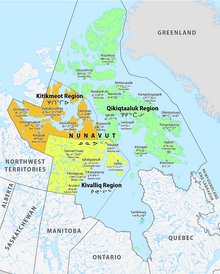
Nunavut is divided into three administrative regions, the Kitikmeot Region, the Kivalliq Region, and the Qikiqtaaluk Region.
Licence plates edit
The first design for Nunavut's licence plate was originally created for the Northwest Territories in the 1970s. The plate has long been famous worldwide for its unique design in the shape of a polar bear.
Nunavut was licensed by the NWT to use the same licence plate design in 1999 when it became a separate territory,[101] but adopted its own plate design in March 2012 for launch in August 2012—a rectangle that prominently features the northern lights, a polar bear and an inuksuk.[101][102]
Symbols edit
The flag and the coat of arms of Nunavut were designed by Andrew Qappik from Pangnirtung.[103]
Territorial dispute edit
A long-simmering dispute between Canada and the U.S. involves the issue of Canadian sovereignty over the Northwest Passage.[104]
Alcohol edit
Due to prohibition laws influenced by local and traditional beliefs, Nunavut has a highly regulated alcohol market. The territory is the last outpost of prohibition in Canada, and it is often easier to obtain firearms than alcohol.[105] Although every community in Nunavut has slightly differing regulations, as a whole it is still very restrictive. Seven communities have complete bans against alcohol and another 14 have orders being restricted by local committees. Due to these laws, a lucrative bootlegging market has appeared in which people mark up the prices of bottles by extraordinary amounts.[106] The RCMP estimate Nunavut's bootleg liquor market rakes in some $10 million a year.[105]
Despite the restrictions, alcohol's availability leads to widespread alcohol related crime. One estimation states some 95% of police calls are alcohol-related.[107] Alcohol is also believed to be a contributing factor to the territory's high rates of violence, suicide, and homicide. A special task force created in 2010 to study and address the territory's increasing alcohol-related problems recommended the government ease alcohol restrictions. With prohibition shown to be highly ineffective historically, some believe these laws contribute to the territory's widespread social ills. Others are skeptical about the effectiveness of liquor sale liberalization and want to ban it completely. In 2014, Nunavut's government moved toward more legalization. In 2017, the first liquor store in 38 years opened in Iqaluit.[105]
Notable people edit
Susan Aglukark is an Inuk singer and songwriter. She has released six albums and has won several Juno Awards. She blends the Inuktitut and English languages with contemporary pop music arrangements to tell the stories of her people, the Inuit of the Arctic.
On May 3, 2008, the Kronos Quartet premiered a collaborative piece with Inuit throat singer Tanya Tagaq, entitled Nunavut, based on an Inuit folk story. Tagaq is also known internationally for her collaborations with Icelandic pop star Björk, and her 2018 novel Split Tooth which was longlisted for the Scotiabank Giller Prize.
Jordin John Kudluk Tootoo (Inuktitut syllabics: ᔪᐊᑕᓐ ᑐᑐ; born February 2, 1983, in Churchill, Manitoba, Canada) played in the National Hockey League (NHL) for from 2003 to 2017. Although born in Manitoba, Tootoo grew up in Rankin Inlet, where he was taught to skate and play hockey by his father, Barney.
Hunter Tootoo, Member of Parliament for the Territory of Nunavut, was elected to the Liberal government in 2015. He served as the Minister of Fisheries, Oceans, and the Canadian Coast Guard until his resignation from the post on May 31, 2016.
See also edit
Footnotes edit
- ^ Northwest Territories is written at the bottom, as the sign predates the creation of Nunavut.
References edit
- ^ "Nunavut". Geographical Names Data Base. Natural Resources Canada.
- ^ a b c d e "Population and dwelling counts: Canada, provinces and territories". Statistics Canada. February 9, 2022. Retrieved February 9, 2022.
- ^ a b "Nunavut". CanadaFAQ.ca. Retrieved April 25, 2020.
- ^ "Population estimates, quarterly". Statistics Canada. September 27, 2023. Archived from the original on September 28, 2023. Retrieved September 28, 2023.
- ^ Nunavummiut, the plural demonym for residents of Nunavut, appears throughout the Government of Nunavut website Archived January 18, 2009, at the Wayback Machine, proceedings of the Nunavut legislature, and elsewhere. Nunavut Housing Corporation, Discussion Paper Released to Engage Nunavummiut on Development of Suicide Prevention Strategy. Alan Rayburn, previous head of the Canadian Permanent Committee of Geographical Names, opined that: "Nunavut is still too young to have acquired [a gentilé], although Nunavutan may be an obvious choice." In Naming Canada: stories about Canadian place names 2001. (2nd ed.). Toronto: University of Toronto Press. (ISBN 978-0-8020-8293-0); p. 50.
- ^ a b "Consolidation of (S.Nu. 2008, c.10) (NIF) Official Languages Act" (PDF). and "Consolidation of Inuit Language Protection Act" (PDF). Government of Nunavut. Retrieved August 5, 2021.
- ^ "Gross domestic product, expenditure-based, provincial and territorial, annual (x 1,000,000)". Statistics Canada. September 21, 2019.
- ^ "Sub-national HDI - Subnational HDI - Global Data Lab". globaldatalab.org. Retrieved June 18, 2020.
- ^ "The Official Flower of Nunavut: Purple Saxifrage". Legislative Assembly of Nunavut. 2011. Retrieved July 31, 2011.
- ^ "The Official Bird of Nunavut: The Rock Ptarmigan". Legislative Assembly of Nunavut. 2011. Archived from the original on May 8, 2014. Retrieved July 31, 2011.
- ^ "Origin of the names of Canada and its provinces and territories". Natural Resources Canada. September 18, 2007. Retrieved December 24, 2017.
- ^ a b "Nunavut Act". Justice Canada. 1993. Retrieved April 26, 2007.
- ^ a b Justice Canada (1993). "Nunavut Land Claims Agreement Act". Archived from the original on August 18, 2016. Retrieved August 7, 2018.
- ^ "How to Get Here". Nunavut Tourism. Archived from the original on August 9, 2014. Retrieved June 22, 2014.
- ^ "Canadian Forces Station Alert - 8 Wing". Royal Canadian Air Force. Archived from the original on September 24, 2015. Retrieved September 18, 2015.
- ^ "Cold Places in Canada". The Canadian Encyclopedia. Retrieved March 12, 2013.
- ^ "Dorset DNA: Genes Trace the Tale of the Arctic's Long-Gone 'Hobbits'". NBC News. August 28, 2014. Retrieved February 20, 2020.
- ^ a b Houmard, Claire (January 1, 2018). "Cultural Continuity from Pre-Dorset to Dorset in the Eastern Canadian Arctic Highlighted by Bone Technology and Typology". Arctic Anthropology. 55 (1): 24–47. doi:10.3368/aa.55.1.24. ISSN 0066-6939. S2CID 165682039.
- ^ George, Jane (September 12, 2008). "Kimmirut site suggests early European contact". Nunatsiaq News. Archived from the original on August 19, 2009.
- ^ Weber, Bob (July 22, 2018). "Ancient Arctic people may have known how to spin yarn long before Vikings arrived". CBC. Retrieved January 2, 2019.
Michele Hayeur Smith of Brown University in Rhode Island, lead author of a recent paper in the Journal of Archaeological Science. Hayeur Smith and her colleagues were looking at scraps of yarn, perhaps used to hang amulets or decorate clothing, from ancient sites on Baffin Island and the Ungava Peninsula. The idea that you would have to learn to spin something from another culture was a bit ludicrous," she said. "It's a pretty intuitive thing to do.
- ^ Friesen, T. Max (December 1, 2004). "Contemporaneity of Dorset and Thule Cultures in the North American Arctic: New Radiocarbon Dates from Victoria Island, Nunavut". Current Anthropology. 45 (5): 685–691. doi:10.1086/425635. ISSN 0011-3204. S2CID 145207595.
- ^ "Nunavut: The Story of Canada's Inuit People [sic]" Archived October 3, 2007, at the Wayback Machine, Maple Leaf Web
- ^ "Grise Fiord: History". Archived from the original on December 28, 2008.
- ^ McGrath, Melanie. The Long Exile: A Tale of Inuit Betrayal and Survival in the High Arctic. Alfred A. Knopf, 2006. Hardcover: ISBN 978-0-00-715796-9 Paperback: ISBN 978-0-00-715797-6
- ^ René Dussault and George Erasmus (1994). "The High Arctic Relocation: A Report on the 1953–55 Relocation". Royal Commission on Aboriginal Peoples. Canadian Government Publishing. Archived from the original on October 1, 2009.
- ^ Royte, Elizabeth (April 8, 2007). "Trail of Tears (review of Melanie McGrath, The Long Exile: A Tale of Inuit Betrayal and Survival in the High Arctic (2006)". The New York Times.
- ^ "Apology for the Inuit High Arctic relocation". www.aadnc-aandc.gc.ca. Government of Canada; Indigenous and Northern Affairs Canada; Communications Branch. Archived from the original on January 9, 2017. Retrieved January 8, 2017.
- ^ "Creation of a New Northwest Territories". Legislative Assembly of The Northwest Territories. Retrieved January 4, 2021.
- ^ Peter Jull (Summer 1988). "Building Nunavut: A Story of Inuit Self-Government". The Northern Review. Yukon College. pp. 59–72. Archived from the original on May 12, 2008. Retrieved February 16, 2009.
- ^ "Creation of Nunavut". CBC. 2006. Retrieved April 26, 2007.
- ^ "Coronavirus: The place in North America with no cases". BBC News. October 19, 2020. Retrieved October 24, 2020.
- ^ Murphy, Jessica (October 19, 2020). "Coronavirus: The place in North America with No Cases". BBC.
- ^ "Nunavut confirms 1st case of COVID-19". CBC. November 6, 2020.
- ^ See List of countries and outlying territories by total area
- ^ Heidt, Daniel (2018). RECONSIDERING CONFEDERATION: Canada's Founding Debates, 1864–1999 (PDF). University of Calgary. pp. 263–264. ISBN 978-1-77385-016-0.
a new Northwest Territories and Nunavut ("our land" in Inuktitut)—were created when the federal government redrew the boundaries in Canada's North, splitting off the central and eastern Canadian Arctic north and east of the tree-line from the rest of the Northwest Territories.
- ^ "Greenland". CIA World Factbook. CIA. Retrieved February 16, 2011.
- ^ "Alert". Canadian Climate Normals 1981–2010. Environment Canada. September 25, 2013. Climate ID: 2400300. Retrieved October 19, 2020.
- ^ "Baker Lake A". Canadian Climate Normals 1981–2010. Environment Canada. September 25, 2013. Climate ID: 2300500. Retrieved October 19, 2020.
- ^ "Cambridge Bay A *". Canadian Climate Normals 1981–2010. Environment Canada. September 25, 2013. Climate ID: 2400600. Retrieved October 19, 2020.
- ^ "Eureka A". Canadian Climate Normals 1981–2010. Environment Canada. September 25, 2013. Retrieved October 19, 2020.
- ^ a b "Iqaluit A". Canadian Climate Normals 1981–2010. Environment and Climate Change Canada. October 31, 2011. Climate ID: 2402590. Archived from the original on May 16, 2017. Retrieved February 24, 2014.
- ^ "Kugluktuk A *". Canadian Climate Normals 1981–2010. Environment Canada. September 25, 2013. Climate ID: 2300902. Retrieved October 19, 2020.
- ^ "Rankin Inlet A". Canadian Climate Normals 1981–2010. Environment Canada. September 25, 2013. Climate ID: 2303401. Retrieved October 19, 2020.
- ^ "Iqaluit (composite station threads)". Canadian Climate Normals 1991-2020 Data. Environment and Climate Change Canada. Archived from the original on April 12, 2024. Retrieved September 29, 2023.
- ^ "Iqaluit, Canada - Detailed climate information and monthly weather forecast". Weather Atlas. Yu Media Group. Retrieved July 6, 2019.
- ^ "Aboriginal Peoples Highlight Tables". 2016 Census. Statistics Canada. 2019. Retrieved July 16, 2019.
- ^ "Immigration and Ethnocultural Diversity Highlight Tables". 2016 Census. Statistics Canada. 2019. Retrieved July 16, 2019.
- ^ "2021 Census of Population". Statistics Canada. 2021. Retrieved April 6, 2023.
- ^ Government of Canada, Statistics Canada (February 9, 2022). "Profile table, Census Profile, 2021 Census of Population - Iqaluit, City (CY) [Census subdivision], Nunavut". www12.statcan.gc.ca. Retrieved April 7, 2023.
- ^ Government of Canada, Statistics Canada (February 9, 2022). "Profile table, Census Profile, 2021 Census of Population - Rankin Inlet, Hamlet (HAM) [Census subdivision], Nunavut". www12.statcan.gc.ca. Retrieved April 7, 2023.
- ^ Government of Canada, Statistics Canada (February 9, 2022). "Profile table, Census Profile, 2021 Census of Population - Arviat, Hamlet (HAM) [Census subdivision], Nunavut". www12.statcan.gc.ca. Retrieved April 7, 2023.
- ^ Government of Canada, Statistics Canada (February 9, 2022). "Profile table, Census Profile, 2021 Census of Population - Baker Lake, Hamlet (HAM) [Census subdivision], Nunavut". www12.statcan.gc.ca. Retrieved April 7, 2023.
- ^ Government of Canada, Statistics Canada (February 9, 2022). "Profile table, Census Profile, 2021 Census of Population - Igloolik, Hamlet (HAM) [Census subdivision], Nunavut". www12.statcan.gc.ca. Retrieved April 7, 2023.
- ^ Government of Canada, Statistics Canada (February 9, 2022). "Profile table, Census Profile, 2021 Census of Population - Cambridge Bay, Hamlet (HAM) [Census subdivision], Nunavut". www12.statcan.gc.ca. Retrieved April 7, 2023.
- ^ Government of Canada, Statistics Canada (February 9, 2022). "Profile table, Census Profile, 2021 Census of Population - Pond Inlet, Hamlet (HAM) [Census subdivision], Nunavut". www12.statcan.gc.ca. Retrieved April 7, 2023.
- ^ Government of Canada, Statistics Canada (February 9, 2022). "Profile table, Census Profile, 2021 Census of Population - Pangnirtung, Hamlet (HAM) [Census subdivision], Nunavut". www12.statcan.gc.ca. Retrieved April 7, 2023.
- ^ Government of Canada, Statistics Canada (February 9, 2022). "Profile table, Census Profile, 2021 Census of Population - Cape Dorset, Hamlet (HAM) [Census subdivision], Nunavut". www12.statcan.gc.ca. Retrieved April 7, 2023.
- ^ Government of Canada, Statistics Canada (February 9, 2022). "Profile table, Census Profile, 2021 Census of Population - Kugluktuk, Hamlet (HAM) [Census subdivision], Nunavut". www12.statcan.gc.ca. Retrieved April 7, 2023.
- ^ "Population and Dwelling Count Highlight Tables, 2016 Census". Statistics Canada. February 8, 2017. Retrieved February 8, 2017.
- ^ Ducharme, Steve (November 2, 2016). "Nunavut smoking rates high, but tobacco law enforcement low". Nunatsiaq News. Retrieved January 11, 2019.
- ^ "9 out of 10 pregnant women in Nunavut smoke, says gov't rep". CBC. January 22, 2016. Retrieved January 11, 2019.
- ^ "We Speak Inuktut". Government of Nunavut, Department of Culture and Heritage. Archived from the original on August 16, 2023. Retrieved April 16, 2023.
- ^ Your Linguistic Rights at the Office of the Language Commissioner of Nunavut
- ^ Ian Martin (December 2000). "Aajiiqatigiingniq Language of Instruction Research Paper" (PDF). p. i.
- ^ Board of Education (2000). "Summary of Aajiiqatigiingniq" (PDF). gov.nu.ca. Archived from the original (PDF) on October 15, 2007. Retrieved October 27, 2007.
- ^ "Detailed Mother Tongue (186), Knowledge of Official Languages (5), Age Groups (17A) (3) (2006 Census)". Statistics Canada. December 7, 2010. Archived from the original on June 5, 2009. Retrieved February 16, 2011.
- ^ Population by knowledge of official language, by province and territory (2006 Census) Archived January 15, 2011, at the Wayback Machine. Statistics Canada. Retrieved January 15, 2010.
- ^ "Religions in Canada—Census 2011". Statistics Canada/Statistique Canada. May 8, 2013.
- ^ "In 2021, more than half of the population of British Columbia and Yukon reported having no religion, while the Christian religion was predominant in the other provinces and territories". October 26, 2022. Retrieved November 26, 2022.
- ^ "Travel". Nunavut Mining Symposium. Archived from the original on June 18, 2018. Retrieved June 17, 2018.
- ^ Venn, David (November 16, 2022). "Vandal rejects Baffinland's Phase 2 expansion; company expected to release statement Thursday". Nunatsiaq News. Nortext Publishing Corporation (Iqaluit). Retrieved December 17, 2022.
- ^ "Development projects". Wolfden Resources. August 31, 2007. Archived from the original on July 19, 2008. Retrieved February 16, 2011.
- ^ "Canada's North struggles to ditch diesel". Alberta Oil Magazine. Archived from the original on October 4, 2013. Retrieved April 3, 2013.
- ^ a b Van Loon, Jeremy (December 7, 2011). "Nunavut Region to Boost Renewable Power to Offset Climate Change". Bloomberg.
- ^ McDonald, N.C.; J.M. Pearce (2012). "Renewable Energy Policies and Programs in Nunavut: Perspectives from the Federal and Territorial Governments". Arctic. 65 (4): 465–475. doi:10.14430/arctic4244.
- ^ Nicole C. McDonald & Joshua M. Pearce, "Community Voices: Perspectives on Renewable Energy in Nunavut" Archived July 9, 2013, at the Wayback Machine, Arctic 66(1), pp. 94–104 (2013).
- ^ Nunavut and Climate Change Archived April 14, 2013, at the Wayback Machine, Aboriginal Affairs and Northern Development Canada
- ^ "Climate Change FAQ". Climate Change Nunavut. Archived from the original on July 9, 2013.
- ^ The NorTerra Group of Companies Archived December 4, 2008, at the Wayback Machine, corporate website
- ^ Northern Transportation Company Limited at NorTerra Archived March 12, 2008, at the Wayback Machine, corporate website
- ^ "Nunasi Corp. sells its stake in NorTerra, Canadian North". April 1, 2014.
- ^ "NunatsiaqOnline 2014-04-01: NEWS: Nunasi Corp. sells its half of Norterra to the Inuvialuit". April 2014. Archived from the original on April 7, 2014. Retrieved April 2, 2014.
- ^ "Nunavut FAQs". Government of Nunavut.
- ^ "Annual Tourism Report 2018-2019" (PDF). Legislative Assembly of Nunavut.
- ^ Ferguson, Mikaela (September 1, 2019). "The Ultimate Nunavut Travel Guide".
- ^ "Newspapers in Nunavut". Altstuff.com. Retrieved November 10, 2011.
- ^ Animation from Cape Dorset
- ^ George, Jane (November 3, 2006). "Nunavut's getting animated". Nunatsiaq News. Retrieved November 8, 2011.
- ^ "Nunavut Animation Lab: Lumaajuuq". Collection. National Film Board of Canada. Retrieved November 8, 2011.
- ^ "Inuit films move online and into northern communities". CBC News. November 2, 2011. Retrieved November 5, 2011.
- ^ "New NFB collection includes 24 films on or by Inuit". Nunatsiaq News. November 4, 2011. Retrieved November 7, 2011.
- ^ "Bringing circus – and new hope – to a remote Arctic village". Christian Science Monitor. December 22, 2009. Retrieved December 28, 2009.
- ^ "Governor in Council". July 4, 2019. Retrieved February 20, 2023.
- ^ "Prime Minister announces the reappointments of the Commissioner of the Northwest Territories and the Administrator of Yukon". June 10, 2021. Retrieved February 20, 2023.
- ^ "Nellie Kusugak named as new Nunavut commissioner". CBC News. June 23, 2015. Retrieved April 9, 2017.
- ^ CBC Digital Archives (2006). "On the Nunavut Campaign Trail". CBC News. Retrieved April 26, 2007.
- ^ Weber, Bob (June 14, 2018). "After Paul Quassa ejected, Nunavut chooses deputy as new premier".
- ^ Frizell, Sara (June 14, 2018). "Joe Savikataaq is the new premier of Nunavut, after non-confidence vote ousts former leader". CBC News North.
- ^ "GN appoints IQ advisory council". Nunatsiaq Online. September 12, 2003. Archived from the original on April 10, 2017. Retrieved April 9, 2017.
- ^ "Prince Edward and wife Sophie arrive in Iqaluit". CBC News. September 13, 2012.
- ^ a b Sarah Rogers (March 6, 2012). "GN launches new license plate". Nunatsiaq Online.
- ^ "Nunavut licence plates 1999–present". 15q.net. Retrieved February 16, 2011.
- ^ "The Coat of Arms of Nunavut". The Legislative Assembly of Nunavut. Retrieved September 13, 2019.
- ^ "The US is picking a fight with Canada over a thawing Arctic shipping route". Quartz. June 27, 2019.
- ^ a b c Hopper, Tristin (September 21, 2014). "Iqaluit hopes to curb alcoholism and binge-drinking by opening city's first beer store in 38 years". National Post. Retrieved November 23, 2015.
- ^ "Prohibition in Northern Canada". VICE. January 14, 2015. Archived from the original on October 28, 2021. Retrieved November 23, 2015 – via YouTube.
- ^ "Department of Justice - Legal Aid, Courtworker, and Public Legal Education and Information Needs in the Northwest Territories". www.justice.gc.ca. Government of Canada, Department of Justice, Electronic Communications. September 30, 2004. Retrieved November 23, 2015.
Further reading edit
- Alia, Valerie (2007). Names and Nunavut Culture and Identity in Arctic Canada. New York: Berghahn Books. ISBN 978-1-84545-165-3.
- Henderson, Ailsa (2007). Nunavut: Rethinking Political Culture. Vancouver: University of British Columbia Press. ISBN 978-0-7748-1423-2.
- Dahl, Jens; Hicks, Jack; Jull, Peter, eds. (2002). Nunavut: Inuit regain control of their lands and their lives. International Work Group for Indigenous Affairs. ISBN 978-87-90730-34-5.
- Kulchyski, Peter Keith (2005). Like the Sound of a Drum: Aboriginal Cultural Politics in Denendeh and Nunavut. Winnipeg: University of Manitoba Press. ISBN 978-0-88755-178-9.
- Sanna, Ellyn, and William Hunter (2008). Canada's Modern-Day Aboriginal Peoples Nunavut & Evolving Relationships. Markham, Ont: Scholastic Canada. ISBN 978-0-7791-7322-8.
External links edit
- Official website of the Nunavut Kavamat / Government of Nunavut

- Nunavut at Curlie
- Map showing regions of Nunavut (from Nunavut Government website)
- Legislative Assembly of Nunavut
- Nunavut Planning Commission
- Annual Nunavut Mining Symposium held in April each year
- Nunavut Tunngavik Inc.: Nunavut Land Claims website
- The Nunavut Act of 1993 at Canadian Legal Information Institute
- Nunavut K-12 bilingual language instruction plan at the Wayback Machine (archived September 26, 2006): Martin, Ian. Aajiiqatigiingniq Language of Instruction Research Paper. Nunavut: Dept. of Education, 2000.
Tourism edit
- Explore Nunavut: Travel information and community guides Archived September 8, 2022, at the Wayback Machine
- Nunavut Parks
Journalism edit
- CBC North Radio: hear Inuktitut and English radio from Nunavut
- Territorial newspaper reporting in Inuktitut and English, Nunatsiaq News
- Nunavut News from News/North