


Summary
O Morrazo is a comarca in the Galician province of Pontevedra. It covers an area of 140.1 sq.km, and the overall population of this comarca was 83,305 at the 2011 Census;[2] the latest official estimate (as at the start of 2018) was 82,445.[3]
O Morrazo | |
|---|---|
 | |
| Country | |
| Autonomous community | |
| Province | Pontevedra |
| Capital | Cangas do Morrazo |
| Municipalities | List |
| Area | |
| • Total | 140.1 km2 (54.1 sq mi) |
| Population (2018)[1] | |
| • Total | 82,445 |
| • Density | 590/km2 (1,500/sq mi) |
| Demonym | morracense |
| Time zone | UTC+1 (CET) |
| • Summer (DST) | UTC+2 (CEST) |
It is bounded on the north by the estuary of Pontevedra, to the east with the comarca of Pontevedra, to the south with the Vigo estuary and to the west by the Atlantic Ocean. This is the smallest comarca in terms of area in Galicia, and one of the five most densely populated.
Municipalities edit
The comarca comprises the following four municipalities:
| Name of municipality |
Population (2001)[4] |
Population (2011)[5] |
Population (2018)[6] |
|---|---|---|---|
| Bueu | 12,350 | 12,339 | 12,148 |
| Cangas do Morrazo | 23,981 | 26,332 | 26,487 |
| Marín | 24,997 | 25,357 | 24,362 |
| Moaña | 17,887 | 19,277 | 19,448 |
| Totals | 79,215 | 83,305 | 82,445 |
Official comarca of Morrazo and historical Morrazo edit
The region of O Morrazo is a peninsula, situated between the estuaries of Pontevedra and Vigo.
The current comarca of the Morrazo corresponds to only part of the traditional region. Apart from the municipalities that compose it, it is traditionally part of Vilaboa as well (minus its parish of Bértola and that of Figueirido and neighborhood of Paredes in the parish of Vilaboa). The Pontevedra parishes of Louizán also forms part of the historical O Morrazo and most of the Salcedo parish. The comarca formerly included the city of Pontevedra which formed part of O Morrazo within its vicariate.
References edit
- ^ Estimate at 1 January 2018: Instituto Nacional de Estadística, Madrid.
- ^ Census at 1 November 2011: Instituto Nacional de Estadística, Madrid.
- ^ Estimate at 1 January 2018: Instituto Nacional de Estadística, Madrid.
- ^ Census at 1 November 2001: Instituto Nacional de Estadística, Madrid.
- ^ Census at 1 November 2011: Instituto Nacional de Estadística, Madrid.
- ^ Estimate at 1 January 2018: Instituto Nacional de Estadística, Madrid.
Gallery edit
-
 Map of Bueu
 -
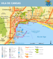 Map of Cangas
 -
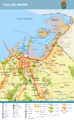 Map of Marín
 -
 Map of Moaña


42°19′57″N 8°43′48″W / 42.33250°N 8.73000°W