


Summary
The Oceanic Shoals Marine Park (formerly known as the Oceanic Shoals Commonwealth Marine Reserve) is an Australian marine park offshore of the Northern Territory, near of Darwin. The marine park covers an area of 71,743 km2 (27,700 sq mi) and is assigned IUCN category VI. It is the largest of the 8 parks managed under the North Marine Parks Network.[3]
| Oceanic Shoals Marine Park | |
|---|---|
IUCN category VI (protected area with sustainable use of natural resources) | |
 Map showing the Oceanic Shoals Marine Park. The shaded area is a National Park Zone ('no take' zone).[1] | |
| Location | Australia |
| Coordinates | 11°13′22″S 128°38′30″E / 11.2228°S 128.6417°E[2] |
| Area | 71,743 km2 (27,700 sq mi) |
| Established | 1 July 2018 |
| Operator | Parks Australia |
| Website | https://parksaustralia.gov.au/marine/parks/north |
Conservation values edit
Species and habitat edit
- Important resting area for turtles between egg laying (internesting area), for the threatened flatback turtle and olive ridley turtle.
- Important foraging area for the threatened loggerhead turtle and olive ridley turtle.[4]
Bioregions and ecology edit
- Examples of the ecosystems of two provincial bioregions: the Northwest Shelf Transition Province (which includes the Bonaparte, Oceanic Shoals, and Tiwi meso-scale bioregions) and the Timor Transition Province.
- Carbonate bank and terrace system of the Van Diemen Rise (unique sea-floor feature).
- Carbonate banks of the Joseph Bonaparte Gulf (enhanced productivity, high biodiversity, unique sea-floor feature).
- Pinnacles of the Bonaparte Basin (enhanced productivity, unique sea-floor feature).
- Shelf break and slope of the Arafura Shelf (unique sea-floor feature).[4]
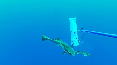
- Animals observed in the park
-

-
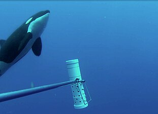 Killer whale (Orcinus orca)
 -


History edit
The marine park was proclaimed under the EPBC Act on 14 December 2013 and renamed Oceanic Shoals Marine Park on 9 October 2017.[3] The management plan and protection measures of the marine park came into effect for the first time on 1 July 2018.
Summary of protection zones edit
The Oceanic Shoals Marine Park has been assigned IUCN protected area category VI. However, within the marine park there are four protection zones, each zone has an IUCN category and related rules for managing activities to ensure the protection of marine habitats and species.[3]
The following table is a summary of the zoning rules within the Oceanic Shoals Marine Park:[3]
| Zone | IUCN | Activities permitted | Total area (km2) | |||||||||||||||||||||||||||||||||||||||||||||||||||||||||||||||||||||||||||||||||||||||||||||||
|---|---|---|---|---|---|---|---|---|---|---|---|---|---|---|---|---|---|---|---|---|---|---|---|---|---|---|---|---|---|---|---|---|---|---|---|---|---|---|---|---|---|---|---|---|---|---|---|---|---|---|---|---|---|---|---|---|---|---|---|---|---|---|---|---|---|---|---|---|---|---|---|---|---|---|---|---|---|---|---|---|---|---|---|---|---|---|---|---|---|---|---|---|---|---|---|---|---|---|
| Vessel transiting | Recreational fishing | Commercial fishing | Commercial aquaculture | Commercial tourism | Mining | |||||||||||||||||||||||||||||||||||||||||||||||||||||||||||||||||||||||||||||||||||||||||||||
| National Park | II | Yes | No | No | No | excludes fishing, with approval | No | 406 | ||||||||||||||||||||||||||||||||||||||||||||||||||||||||||||||||||||||||||||||||||||||||||
| Habitat Protection | IV | Yes | Yes | some, with approval | with approval | with approval | No | 6,929 | ||||||||||||||||||||||||||||||||||||||||||||||||||||||||||||||||||||||||||||||||||||||||||
| Multiple Use | VI | Yes | Yes | most, with approval | with approval | with approval | with approval | 39,964 | ||||||||||||||||||||||||||||||||||||||||||||||||||||||||||||||||||||||||||||||||||||||||||
| Special Purpose (Trawl) | VI | Yes | Yes | excluding longline, with approval | with approval | with approval | with approval | 24,444 | ||||||||||||||||||||||||||||||||||||||||||||||||||||||||||||||||||||||||||||||||||||||||||
| External link: Zoning and rules for the North Marine Parks Network | ||||||||||||||||||||||||||||||||||||||||||||||||||||||||||||||||||||||||||||||||||||||||||||||||||
See also edit
References edit
- ^ Map data: Sanctuary IUCN Ia and National Park IUCN II zones ('no take' zones) from Australian Marine Parks, (2018) Australian Government Department of the Environment and Energy. CC BY 4.0. http://www.environment.gov.au/fed/catalog/search/resource/details.page?uuid=%7BCD8877F3-8C39-4A20-A53F-070FBEE5AF3C%7D
- ^ "Way: Oceanic Shoals Marine Park (608000450)". OpenStreetMap. Retrieved 17 August 2018.
- ^ a b c d "North Marine Parks Network Management Plan 2018" (PDF). Parks Australia. Retrieved 16 August 2018.
- ^ a b "Oceanic Shoals Commonwealth Marine Reserve". environment.gov.au. © Commonwealth of Australia (CC BY 3.0 AU). Retrieved 16 August 2018.
External links edit
- North Marine Parks Network - Parks Australia
- North Marine Parks Network - environment.gov.au (outdated)