
KNOWPIA
WELCOME TO KNOWPIA

Ochtezeele 
Summary
Ochtezeele (French pronunciation: [ɔktəzɛl]; from Flemish; Ochtezele in modern Dutch spelling) is a commune in the Nord department in northern France.[3]
Ochtezeele
Ochtezele | |
|---|---|
 The road into Ochtezeele | |
Location of Ochtezeele .mw-parser-output .locmap .od{position:absolute}.mw-parser-output .locmap .id{position:absolute;line-height:0}.mw-parser-output .locmap .l0{font-size:0;position:absolute}.mw-parser-output .locmap .pv{line-height:110%;position:absolute;text-align:center}.mw-parser-output .locmap .pl{line-height:110%;position:absolute;top:-0.75em;text-align:right}.mw-parser-output .locmap .pr{line-height:110%;position:absolute;top:-0.75em;text-align:left}.mw-parser-output .locmap .pv>div{display:inline;padding:1px}.mw-parser-output .locmap .pl>div{display:inline;padding:1px;float:right}.mw-parser-output .locmap .pr>div{display:inline;padding:1px;float:left}html.skin-theme-clientpref-night .mw-parser-output .od,html.skin-theme-clientpref-night .mw-parser-output .od .pv>div,html.skin-theme-clientpref-night .mw-parser-output .od .pl>div,html.skin-theme-clientpref-night .mw-parser-output .od .pr>div{background:#000;color:#fff}html.skin-theme-clientpref-night .mw-parser-output .locmap{filter:grayscale(0.6)}@media(prefers-color-scheme:dark){html.skin-theme-clientpref-os .mw-parser-output .locmap{filter:grayscale(0.6)}html.skin-theme-clientpref-os .mw-parser-output .od,html.skin-theme-clientpref-os .mw-parser-output .od .pv>div,html.skin-theme-clientpref-os .mw-parser-output .od .pl>div,html.skin-theme-clientpref-os .mw-parser-output .od .pr>div{background:#000;color:#fff}}  Ochtezeele  Ochtezeele | |
| Coordinates: 50°49′04″N 2°24′10″E / 50.8178°N 2.4028°E | |
| Country | France |
| Region | Hauts-de-France |
| Department | Nord |
| Arrondissement | Dunkerque |
| Canton | Wormhout |
| Intercommunality | Flandre Intérieure |
| Government | |
| • Mayor (2022–2026) | Joël Vermeulen[1] |
| Area 1 | 5.58 km2 (2.15 sq mi) |
| Population (2021)[2] | 375 |
| • Density | 67/km2 (170/sq mi) |
| Demonym | Ochtezeelois (es) |
| Time zone | UTC+01:00 (CET) |
| • Summer (DST) | UTC+02:00 (CEST) |
| INSEE/Postal code | 59443 /59670 |
| Elevation | 19–62 m (62–203 ft) (avg. 24 m or 79 ft) |
| 1 French Land Register data, which excludes lakes, ponds, glaciers > 1 km2 (0.386 sq mi or 247 acres) and river estuaries. | |
The small river Peene Becque flows through the village.
The closest airport to Ochtezeele is Lille Airport (56 km).
Heraldry edit
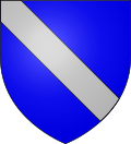 |
The arms of Ochtezeele are blazoned : Azure, a bend argent. (Bouvignies, Jolimetz and Ochtezeele use the same arms.)
See also
edit
References edit
Wikimedia Commons has media related to Ochtezeele.
|