


Summary
Oderberg (German: [ˈoːdɐbɛʁk] ⓘ) is a town in the district of Barnim, in Brandenburg in northeastern Germany. It is situated 16 km east of Eberswalde, and 27 km southwest of Schwedt, close to the border with Poland, and in close vicinity of Berlin.
Oderberg | |
|---|---|
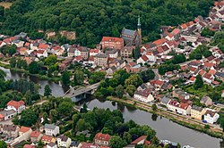 Aerial view of the town center | |
 Coat of arms | |
Location of Oderberg within Barnim district  | |
 Oderberg  Oderberg | |
| Coordinates: 52°52′00″N 14°03′00″E / 52.86667°N 14.05000°E | |
| Country | Germany |
| State | Brandenburg |
| District | Barnim |
| Municipal assoc. | Britz-Chorin-Oderberg |
| Government | |
| • Mayor (2019–24) | Martina Hähnel[1] |
| Area | |
| • Total | 35.31 km2 (13.63 sq mi) |
| Elevation | 5 m (16 ft) |
| Population (2022-12-31)[2] | |
| • Total | 2,143 |
| • Density | 61/km2 (160/sq mi) |
| Time zone | UTC+01:00 (CET) |
| • Summer (DST) | UTC+02:00 (CEST) |
| Postal codes | 16248 |
| Dialling codes | 033369 |
| Vehicle registration | BAR |
| Website | www |
Overview edit
The territory has many lakes, remnants from the ice age. The area is widely used for outdoor recreation, such as biking, walking and boating. As Biosphere region it is home to many species of wildlife. Oderberg is closest to the Oder river crossing leading directly to Cedynia, Poland.
History edit

In 1319, the town was captured by Henry II, Lord of Mecklenburg.[3] In 1320, it was captured by the Duchy of Pomerania, however, it was eventually lost by Pomerania in September 1321.[4] Afterwards it passed to the Margraviate of Brandenburg, and from 1373 to 1415 it was part of the Bohemian (Czech) Crown.
From 1701, Oderberg was part of the Kingdom of Prussia, and from 1871 also the German Empire. From 1815 to 1947, it was administratively located in the Province of Brandenburg. After World War II, it was part of East Germany until 1990, administratively located within the State of Brandenburg from 1947 to 1952, Bezirk Frankfurt from 1952 to 1990 and since 1990 again of Brandenburg.
Demography edit
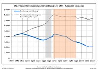
|
|
|
Gallery edit
-
 Town hall
 -
 Church in Neuendorf
 -
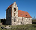
 Saint Nicholas church
 -
 Museum


References edit
- ^ Landkreis Barnim Wahl der Bürgermeisterin / des Bürgermeisters, accessed 30 June 2021.
- ^ "Bevölkerungsentwicklung und Bevölkerungsstandim Land Brandenburg Dezember 2022" (PDF). Amt für Statistik Berlin-Brandenburg (in German). June 2023.
- ^ Rymar, Edward (1979). "Rywalizacja o ziemię lubuską i kasztelanię międzyrzecką w latach 1319–1326, ze szczególnym uwzględnieniem stosunków pomorsko-śląskch". Śląski Kwartalnik Historyczny Sobótka (in Polish). XXXIV (4). Wrocław: Zakład Narodowy im. Ossolińskich, Wydawnictwo Polskiej Akademii Nauk: 477.
- ^ Rymar, pp. 485–487
- ^ Detailed data sources are to be found in the Wikimedia Commons.Population Projection Brandenburg at Wikimedia Commons