


Summary
Ogygia Island (Bulgarian: остров Огигия, romanized: ostrov Ogygia, IPA: [ˈɔstrof oˈɟiɟjɐ]) is the 420 m long in west-east direction and 70 m wide rocky island separated by a 110 m wide passage from Hall Peninsula on the east side of Snow Island in the South Shetland Islands. Surface area 2 ha. It is part of the southwest coast of Ivaylo Cove.[1] The area was visited by early 19th century sealers.[2]
 | |
 Ogygia Island Location of Ogygia Island  Ogygia Island Ogygia Island (South Shetland Islands) | |
| Geography | |
|---|---|
| Location | Antarctica |
| Coordinates | 62°46′34″S 61°14′15″W / 62.77611°S 61.23750°W |
| Archipelago | South Shetland Islands |
| Area | 2 ha (4.9 acres) |
| Length | 420 m (1380 ft) |
| Width | 70 m (230 ft) |
| Administration | |
| Administered under the Antarctic Treaty System | |
| Demographics | |
| Population | uninhabited |
The feature is named after the mythical island Ogygia, home of the nymph Calypso.[1]
Location edit
Ogygia Island is located at 62°46′34″S 61°14′15″W / 62.77611°S 61.23750°W, which is 580 m south of Trapecio Island, 6 km south-southwest of the northeast extremity of President Head, 12.15 km northeast of Cape Conway and 29.8 km northwest of Deception Island. Bulgarian mapping in 2009 and 2017.
Maps edit
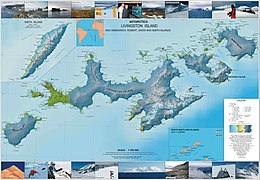
- L. Ivanov. Antarctica: Livingston Island and Greenwich, Robert, Snow and Smith Islands. Scale 1:120000 topographic map. Troyan: Manfred Wörner Foundation, 2010. ISBN 978-954-92032-9-5 (First edition 2009. ISBN 978-954-92032-6-4)
- L. Ivanov. Antarctica: Livingston Island and Smith Island. Scale 1:100000 topographic map. Manfred Wörner Foundation, 2017. ISBN 978-619-90008-3-0
- Antarctic Digital Database (ADD). Scale 1:250000 topographic map of Antarctica. Scientific Committee on Antarctic Research (SCAR). Since 1993, regularly upgraded and updated
See also edit
Notes edit
References edit
- Ogygia Island. SCAR Composite Gazetteer of Antarctica
- Bulgarian Antarctic Gazetteer. Antarctic Place-names Commission. (details in Bulgarian, basic data in English)
External links edit
- Ogygia Island. Adjusted Copernix satellite image
This article includes information from the Antarctic Place-names Commission of Bulgaria which is used with permission.