


Summary
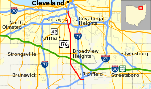
Ohio State Route 176 (SR 176) is a route linking Interstate 71 (I-71) in Cleveland to I-77 near Richfield. The freeway portion is known as the Jennings Freeway, while the at-grade portion is mostly Broadview Road.
State Route 176 | ||||
|---|---|---|---|---|
 | ||||
| Route information | ||||
| Maintained by ODOT | ||||
| Length | 19.42 mi[1] (31.25 km) | |||
| Existed | 1924–present | |||
| Major junctions | ||||
| South end | ||||
| North end | ||||
| Location | ||||
| Country | United States | |||
| State | Ohio | |||
| Counties | Summit, Cuyahoga | |||
| Highway system | ||||
| ||||
| ||||

Route description edit

From its southern terminus at I-77 to SR 17, SR 176 has at-grade intersections. SR 176's route from SR 17 (Brookpark Road) to I-71 is a limited-access highway. From 1968, it functioned as an exit off of I-71 and side streets, terminating at Denison Road and serving businesses in the industrial valley. As traffic volumes to suburbs such as Parma and Parma Heights increased – and to relieve traffic from I-77 to I-480 – the freeway portion of the route (known as the Jennings Freeway) was extended as originally planned to I-480 and Brookpark Road (SR 17), opening December 8, 1998.[2][3]
History edit
Soon after its creation, SR 176 was extended to Akron, routed with U.S. Route 21 (US 21; here part of Cleveland-Massillon Road), over SR 92 (Ghent Road), replacing it, and along Market Street with a portion SR 18 (at the time, SR 18 followed Twin Oaks Road from Market Street) to downtown Akron, ending at the High Street/Broadway Street couplet (then SR 5, 8, and 261, now just SR 261). After the completion of I-77, SR 176 was relocated along Wheatley Road and moved on to I-77 from exits 143 to 138, before rejoining its original alignment. In the early 1970s, US 21 was changed to SR 21 at that location, and SR 176 was truncated at I-77 exit 143. SR 18 was also truncated, but realigned to follow the entirety of Market Street (which had also carried the also-truncated SR 8 east of High and Broadway) to end at SR 91.[4]
Major intersections edit
| County | Location | mi[1] | km | Exit | Destinations | Notes |
|---|---|---|---|---|---|---|
| Summit | Richfield | 0.00 | 0.00 | Exit 143 on I-77 / SR 21 | ||
| 2.54 | 4.09 | |||||
| Cuyahoga | Broadview Heights | 8.12 | 13.07 | |||
| Cleveland | 15.47 | 24.90 | Western terminus of SR 17 concurrency | |||
| 15.72 | 25.30 | Eastern terminus of SR 17 concurrency | ||||
| 15.79 | 25.41 | Southern terminus of Jennings Freeway | ||||
| 16.35 | 26.31 | 16A-B | Southbound exit and northbound entrance; signed as exits 16A (east) and 16B (west) | |||
| 16.94 | 27.26 | 16C | Spring Road / Hinckley Parkway | Signed as exit 16 northbound | ||
| 18.26 | 29.39 | 18A | Denison Avenue / Harvard Avenue | |||
| 18.45 | 29.69 | 18B | Jennings Road / Steelyard Drive | Southbound exit and northbound entrance | ||
| 18.94 | 30.48 | – | Southbound exit only; exit 246 on I-71 | |||
| 19.24 | 30.96 | – | Northbound exit only; exit 246 on I-71 | |||
| 19.42 | 31.25 | – | Exit 170B on I-90; exit 1A on I-490 | |||
1.000 mi = 1.609 km; 1.000 km = 0.621 mi
| ||||||
Route 176J edit
State Route 176J | |
|---|---|
| Location | Cleveland |
| Length | 1.72 mi[1] (2.77 km) |
| Existed | 1998–c. 2017 |
Route 176J was the section of Broadview Road between Brookpark Road (SR 17) in Parma and Pearl Road (U.S. Route 42) in the Old Brooklyn neighborhood of Cleveland, which formerly carried SR 176. Since the relocation of SR 176 onto the Jennings Freeway in 1998, this roadway was intended to be turned over from the state system to the local government ("J" suffix meaning "awaiting abandonment").[5][6] The road was kept under state maintenance until it was turned over to the city of Cleveland between 2015 and 2017.[7][8]
References edit
- ^ a b c Ohio Department of Transportation. "Technical Services Straight Line Diagrams". Retrieved April 30, 2010.
- ^ Perkins, Olivera (1998-12-06). "Freeway Opens After 40 Years of Congestion". The Plain Dealer. Retrieved 2009-09-30.
- ^ "Jennings Freeway Open at Last". The Plain Dealer. 1998-12-09. Retrieved 2009-09-30.
- ^ Route 176[unreliable source] Archived December 31, 2004, at the Wayback Machine
- ^ ODOT Technical Services Traffic Survey Report (Cuyahoga County 2003) Archived 2007-08-07 at the Wayback Machine
- ^ ODOT Straight Line Diagrams legend Archived 2008-04-08 at the Wayback Machine
- ^ Ohio Department of Transportation (June 24, 2015). "Technical Services DESTAPE - Cuyahoga County" (PDF). Archived from the original (PDF) on March 3, 2016. Retrieved April 26, 2019.
- ^ Ohio Department of Transportation (August 30, 2017). "Technical Services DESTAPE - Cuyahoga County" (PDF). Archived from the original (PDF) on January 22, 2018. Retrieved April 26, 2019.
External links edit
- Roadfan.com's Jennings Freeway page