
KNOWPIA
WELCOME TO KNOWPIA

Oisy-le-Verger 
Summary
Oisy-le-Verger (French pronunciation: [wazi lə vɛʁʒe]) is a commune in the Pas-de-Calais department in the Hauts-de-France region of France.[3]
Oisy-le-Verger | |
|---|---|
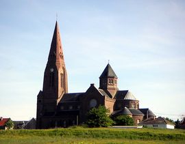 The church of Oisy-le-Verger | |
 Coat of arms | |
Location of Oisy-le-Verger .mw-parser-output .locmap .od{position:absolute}.mw-parser-output .locmap .id{position:absolute;line-height:0}.mw-parser-output .locmap .l0{font-size:0;position:absolute}.mw-parser-output .locmap .pv{line-height:110%;position:absolute;text-align:center}.mw-parser-output .locmap .pl{line-height:110%;position:absolute;top:-0.75em;text-align:right}.mw-parser-output .locmap .pr{line-height:110%;position:absolute;top:-0.75em;text-align:left}.mw-parser-output .locmap .pv>div{display:inline;padding:1px}.mw-parser-output .locmap .pl>div{display:inline;padding:1px;float:right}.mw-parser-output .locmap .pr>div{display:inline;padding:1px;float:left}html.skin-theme-clientpref-night .mw-parser-output .od,html.skin-theme-clientpref-night .mw-parser-output .od .pv>div,html.skin-theme-clientpref-night .mw-parser-output .od .pl>div,html.skin-theme-clientpref-night .mw-parser-output .od .pr>div{background:#000;color:#fff}html.skin-theme-clientpref-night .mw-parser-output .locmap{filter:grayscale(0.6)}@media(prefers-color-scheme:dark){html.skin-theme-clientpref-os .mw-parser-output .locmap{filter:grayscale(0.6)}html.skin-theme-clientpref-os .mw-parser-output .od,html.skin-theme-clientpref-os .mw-parser-output .od .pv>div,html.skin-theme-clientpref-os .mw-parser-output .od .pl>div,html.skin-theme-clientpref-os .mw-parser-output .od .pr>div{background:#000;color:#fff}}  Oisy-le-Verger  Oisy-le-Verger | |
| Coordinates: 50°15′03″N 3°07′29″E / 50.2508°N 3.1247°E | |
| Country | France |
| Region | Hauts-de-France |
| Department | Pas-de-Calais |
| Arrondissement | Arras |
| Canton | Bapaume |
| Intercommunality | CC Osartis Marquion |
| Government | |
| • Mayor (2020–2026) | Marie-Christine Guenot[1] |
| Area 1 | 11.36 km2 (4.39 sq mi) |
| Population (2021)[2] | 1,188 |
| • Density | 100/km2 (270/sq mi) |
| Time zone | UTC+01:00 (CET) |
| • Summer (DST) | UTC+02:00 (CEST) |
| INSEE/Postal code | 62638 /62860 |
| Elevation | 32–77 m (105–253 ft) (avg. 78 m or 256 ft) |
| 1 French Land Register data, which excludes lakes, ponds, glaciers > 1 km2 (0.386 sq mi or 247 acres) and river estuaries. | |
Geography edit
Oisy-le-Verger is a farming village situated 15 miles (24 km) east of Arras, at the junction of the D21 and D14 roads.
Population edit
| Year | Pop. | ±% p.a. |
|---|---|---|
| 1968 | 1,328 | — |
| 1975 | 1,310 | −0.19% |
| 1982 | 1,278 | −0.35% |
| 1990 | 1,301 | +0.22% |
| 1999 | 1,260 | −0.36% |
| 2007 | 1,285 | +0.25% |
| 2012 | 1,251 | −0.53% |
| 2017 | 1,217 | −0.55% |
| Source: INSEE[4] | ||
Places of interest edit
- The church of St. Didier, dating from the twentieth century.
- Traces of an old castle and watermill.
- Remains of the Cistercian abbey founded in 1227.
- A pre-Roman menhir.
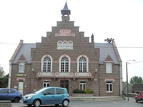
- The museum, housed in the mairie (town hall).
See also edit
References edit
- ^ "Répertoire national des élus: les maires" (in French). data.gouv.fr, Plateforme ouverte des données publiques françaises. 13 September 2022.
- ^ "Populations légales 2021". The National Institute of Statistics and Economic Studies. 28 December 2023.
- ^ INSEE commune file
- ^ Population en historique depuis 1968, INSEE
Wikimedia Commons has media related to Oisy-le-Verger.