


Summary
State Highway 2, abbreviated SH-2 or OK-2, is a designation for two distinct highways maintained by the U.S. state of Oklahoma. Though they were once connected, the middle section of highway was concurrent with three different U.S. highways, so the middle section was decommissioned for reasons of redundancy.
State Highway 2 | ||||
|---|---|---|---|---|
 | ||||
| Route information | ||||
| Maintained by ODOT | ||||
| Section 1 | ||||
| Length | 116.7 mi[1] (187.8 km) | |||
| South end | ||||
| Major intersections | ||||
| North end | ||||
| Section 2 | ||||
| Length | 26.3 mi[2] (42.3 km) | |||
| South end | ||||
| North end | ||||
| Location | ||||
| Country | United States | |||
| State | Oklahoma | |||
| Highway system | ||||
| ||||
| ||||

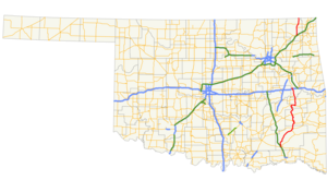
The southern section of highway runs from Antlers to U.S. Highway 64 near Warner, covering 116.7 miles (187.8 km)[1] through the southeastern part of the state. The northern SH-2 runs for 26.3 miles (42.3 km)[2] through Craig County in northeastern Oklahoma.
Route descriptions edit
Southern section edit

The southern section of SH-2 begins at SH-3 in Antlers. It travels north-northwest from here, roughly parallelling the Kiamichi River, until reaching Clayton and US-271. North of Clayton, Highway 2 and US-271 overlap for 3 miles (5 km). Immediately after this, SH-2 meets SH-43's eastern terminus southeast of Sardis Lake. SH-2 then crosses over the lake and meets SH-1/SH-63, and the three form a six-mile (10 km) concurrency. This area is mountainous and has some tight hairpin curves. After the concurrency Highway 2 continues northward, meeting US-270 at Wilburton.
SH-2 then passes Robbers Cave State Park and the eastern edge of the Sansbois Mountains before reaching SH-31 east of Quinton, and the two form a six-mile (10 km) concurrency until Kinta. Ten miles (16 km) north of here, Highway 2 meets SH-9. Three miles (4.9 km) later, the highway passes the eastern terminus of SH-71, south of the town of Porum, Oklahoma. 10 miles (16 km) later, SH-2 meets US-266, which it will overlap until its end. After having an interchange at I-40 milemarker 278, both SH-2 and US-266 end at US-64 near Warner.
Northern section edit
The northern SH-2 begins at US-60/US-69 in Vinita. It then heads due north, meeting SH-25 four miles (6.5 km) west of Bluejacket. Six miles north of here, it comes to a junction with US-59 and SH-10 in Welch, Oklahoma.
All signage for SH-2 ends at US-59/SH-10 in Welch. However, the official definition of the highway contains an unsigned concurrency with US-59 to the point where it crosses the state line into Kansas.[3]
History edit
The northern SH-2, between Vinita and the Kansas state line, was once part of US-73.[4]
Until the early 1980s a portion of SH-2 was one of the last unpaved state highways in the Oklahoma road network. The section between the communities of Kosoma, Oklahoma and Stanley, Oklahoma in the Kiamichi River Valley, remained gravel. Its builders during the 1930s and 1940s, in order to save the expense of building two bridges across the Kiamichi River, routed the highway mid-way up the flank of Bull Creek Mountain. The highway traversed the mountain at its midway point, with no shoulders or guard rails. During the 1980s a new route was opened in the floor of the valley, featuring modern bridges across Pine Creek and the Kiamichi River. The old route on Bull Creek Mountain was decommissioned and is no longer in use.[citation needed]
The old route from Clayton to Antlers (using Bull Creek Mountain) was known as Hwy 144. When the Route was renovated through the Valley (crossing the river in 2 places) and paved, the Route was renamed SH2.[5]
The section of SH-2 between I-40 and SH-9 was pressed into service as a detour for eastbound I-40 traffic after the collapse of its bridge over the Arkansas River on May 26, 2002.[6][7]
Junction list edit
Southern section edit
| County | Location | mi[1] | km | Destinations | Notes |
|---|---|---|---|---|---|
| Pushmataha | Antlers | 0.0 | 0.0 | Southern terminus | |
| Clayton | 33.4 | 53.8 | Southern end of US-271 concurrency | ||
| | 36.7 | 59.1 | Northern end of US-271 concurrency | ||
| | 38.8 | 62.4 | |||
| Latimer | | 45.5 | 73.2 | Southern end of SH-1/SH-63 concurrency | |
| | 51.6 | 83.0 | Northern end of SH-1/SH-63 concurrency | ||
| | 63.3 | 101.9 | Southern end of US-270 concurrency | ||
| Wilburton | 63.8 | 102.7 | Northern end of US-270 concurrency | ||
| Haskell | | 82.8 | 133.3 | Western end of SH-31 concurrency | |
| Kinta | 88.5 | 142.4 | Eastern end of SH-31 concurrency | ||
| Whitefield | 98.6 | 158.7 | |||
| Muskogee | | 104.5 | 168.2 | Eastern terminus of SH-71 | |
| | 114.0 | 183.5 | Southern end of US-266 concurrency | ||
| | 115.1 | 185.2 | I-40 exit 278 | ||
| Warner | 116.7 | 187.8 | Northern terminus of SH-2, eastern terminus of US-266 | ||
1.000 mi = 1.609 km; 1.000 km = 0.621 mi
| |||||
Northern section edit
| County | Location | mi[2] | km | Destinations | Notes |
|---|---|---|---|---|---|
| Craig | Vinita | 0.0 | 0.0 | Southern terminus | |
| Pyramid Corners | 11.4 | 18.3 | |||
| Welch | 17.3 | 27.8 | Southern end of US-59 concurrency | ||
| Oklahoma–Kansas state line | 26.3 | 42.3 | |||
1.000 mi = 1.609 km; 1.000 km = 0.621 mi
| |||||
References edit
- ^ a b c Google (October 28, 2012). "Oklahoma State Highway 2" (Map). Google Maps. Google. Retrieved October 28, 2012.
- ^ a b c Google (October 30, 2012). "Oklahoma State Highway 2" (Map). Google Maps. Google. Retrieved October 30, 2012.
- ^ Oklahoma Department of Transportation (n.d.). Control Section Maps: Craig County (PDF) (Map) (2010–2011 ed.). Scale not given. Oklahoma City: Oklahoma Department of Transportation. Retrieved October 28, 2012.
- ^ Map Showing Condition of Improvement of the State Highway System and Landing Fields (PDF) (Map) (February 1934 ed.). Oklahoma Department of Highways. Retrieved May 10, 2013.
- ^ "Oklahoma 1970" (PDF). Oklahoma Department of Transportation.
- ^ "I-40 Webbers Falls Local Detour Route & Map". Oklahoma Department of Transportation. Retrieved 2014-01-10.
- ^ Stewart, D. R. (2002-05-29). "Truckers weigh cost of detours". Tulsa World. Retrieved 2014-01-10.
External links edit
- SH-2's southern section at OKHighways
- SH-2's northern section at OKHighways