


Summary
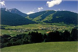
Olang (German pronunciation: [ˈoˑlaŋ]; Italian: Valdaora [valˈdaːora]) is a comune (municipality) in South Tyrol in northern Italy, located about 60 kilometres (37 mi) northeast of the city of Bolzano. There is no settlement named Olang.
Olang | |
|---|---|
| Gemeinde Olang Comune di Valdaora | |
 Olang | |
Location of Olang .mw-parser-output .locmap .od{position:absolute}.mw-parser-output .locmap .id{position:absolute;line-height:0}.mw-parser-output .locmap .l0{font-size:0;position:absolute}.mw-parser-output .locmap .pv{line-height:110%;position:absolute;text-align:center}.mw-parser-output .locmap .pl{line-height:110%;position:absolute;top:-0.75em;text-align:right}.mw-parser-output .locmap .pr{line-height:110%;position:absolute;top:-0.75em;text-align:left}.mw-parser-output .locmap .pv>div{display:inline;padding:1px}.mw-parser-output .locmap .pl>div{display:inline;padding:1px;float:right}.mw-parser-output .locmap .pr>div{display:inline;padding:1px;float:left}html.skin-theme-clientpref-night .mw-parser-output .od,html.skin-theme-clientpref-night .mw-parser-output .od .pv>div,html.skin-theme-clientpref-night .mw-parser-output .od .pl>div,html.skin-theme-clientpref-night .mw-parser-output .od .pr>div{background:#000;color:#fff}html.skin-theme-clientpref-night .mw-parser-output .locmap{filter:grayscale(0.6)}@media(prefers-color-scheme:dark){html.skin-theme-clientpref-os .mw-parser-output .locmap{filter:grayscale(0.6)}html.skin-theme-clientpref-os .mw-parser-output .od,html.skin-theme-clientpref-os .mw-parser-output .od .pv>div,html.skin-theme-clientpref-os .mw-parser-output .od .pl>div,html.skin-theme-clientpref-os .mw-parser-output .od .pr>div{background:#000;color:#fff}}  Olang Location of Olang in Italy  Olang Olang (Trentino-Alto Adige/Südtirol) | |
| Coordinates: 46°46′N 12°2′E / 46.767°N 12.033°E | |
| Country | Italy |
| Region | Trentino-Alto Adige/Südtirol |
| Province | South Tyrol (BZ) |
| Frazioni | Geiselsberg (Sorafurcia), Mitterolang (Valdaora di Mezzo), Niederolang (Valdaora di Sotto), Oberolang (Valdaora di Sopra) |
| Government | |
| • Mayor | Georg Reden |
| Area | |
| • Total | 49.0 km2 (18.9 sq mi) |
| Population (Dec. 2015)[2] | |
| • Total | 3.132 |
| • Density | 0.064/km2 (0.17/sq mi) |
| Demonym(s) | German: Olanger Italian: di Valdaora |
| Time zone | UTC+1 (CET) |
| • Summer (DST) | UTC+2 (CEST) |
| Postal code | 39030 |
| Dialing code | 0474 |
| Website | Official website |

Geography edit
As of 31 December 2015, it had a population of 3,132 and an area of 49.0 square kilometres (18.9 sq mi).[3]
Olang borders the following municipalities: Bruneck, Mareo, Prags, Rasen-Antholz, and Welsberg-Taisten.
Frazioni edit
The municipality of Olang contains the frazioni (subdivisions, mainly villages and hamlets) Geiselsberg (Sorafurcia), Mitterolang (Valdaora di Mezzo), Niederolang (Valdaora di Sotto) and Oberolang (Valdaora di Sopra).
History edit
Coat-of-arms edit
The emblem is argent a bend vert on which are represented three cart’s wheels. The wheels symbolize the villages of Mitterolang, Oberolang and Niederolang and their disposition in the valley. The emblem was granted in 1968.[4]
Society edit
Linguistic distribution edit
According to the 2011 census, 96.47% of the population speak German, 3.18% Italian and 0.34% Ladin as first language.[5]
Demographic evolution edit

References edit
- ^ "Superficie di Comuni Province e Regioni italiane al 9 ottobre 2011". Italian National Institute of Statistics. Retrieved 16 March 2019.
- ^ "Popolazione Residente al 1° Gennaio 2018". Italian National Institute of Statistics. Retrieved 16 March 2019.
- ^ All demographics and other statistics: Italian statistical institute Istat.
- ^ Heraldry of the World: Olang
- ^ "Volkszählung 2011/Censimento della popolazione 2011". astat info (38). Provincial Statistics Institute of the Autonomous Province of South Tyrol: 6–7. June 2012. Retrieved 2012-06-14.
External links edit
![]() Media related to Olang at Wikimedia Commons
Media related to Olang at Wikimedia Commons
- (in German and Italian) Homepage of the municipality